Category:Lippischer Zweiviertelmeilenstein (Kohlstädt)
Jump to navigation
Jump to search
| Object location | | View all coordinates using: OpenStreetMap |
|---|
| NO WIKIDATA ID FOUND! Search for Lippischer Zweiviertelmeilenstein (Kohlstädt) on Wikidata | |
| Upload media |
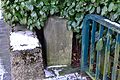
| This category shows a heritage building in Germany, located in the North Rhine-Westphalian municipality Schlangen (Gemeinde) (no. 12 OT Kohlstädt). |
Media in category "Lippischer Zweiviertelmeilenstein (Kohlstädt)"
The following 3 files are in this category, out of 3 total.
-
 Kohlstädt, Zweiviertelmeilenstein (1).jpg 1,200 × 1,600; 619 KB
-
 Kohlstädt, Zweiviertelmeilenstein (2).jpg 1,536 × 2,048; 670 KB
-
 Schlangen - 12 - Meilenstein B1 (2).jpg 4,608 × 3,072; 5.27 MB
.jpg)
.jpg)
.jpg)