Category:Lingebos
Jump to navigation
Jump to search
| Object location | | View all coordinates using: OpenStreetMap |
|---|
Nederlands: Afbeeldingen van het Lingebos bij het recreatieterrein het Lingebos, Haarweg 6A, 4214 KL Vuren, in de provincie Gelderland in Nederland. Het Lingebos ligt nabij Vuren en Gorinchem. Het wordt beheerd door Staatsbosbeheer
Media in category "Lingebos"
The following 23 files are in this category, out of 23 total.
-
 De Haarweg slingert door het Lingebos bij het dorp Vuren.jpg 4,770 × 3,177; 7.58 MB
-
 De Poelweg bij het Lingebos niet ver van Gorichem en niet ver van Vuren.jpg 4,770 × 3,177; 6.53 MB
-
 De Poelweg ten zuiden van het Lingebos gezien in westelijke richting.jpg 4,770 × 3,177; 7.14 MB
-
 De speelplas in het Lingebos bij Vuren in de gemeente Lingewaal.jpg 4,770 × 3,177; 6.54 MB
-
 De westelijke ingang van het Lingebos aan de Haardijk.jpg 4,770 × 3,177; 4.07 MB
-
 Dijkje ten Oosten van het Lingebos bij Vuren.jpg 4,770 × 3,177; 6.95 MB
-
 Een mooi waterspel één van de vele atracties in het Lingebos.jpg 4,770 × 3,177; 4.21 MB
-
 Glasmozaïek in het Lingebos geplaatst bij de opening in1969.jpg 3,913 × 1,280; 1.55 MB
-
 Haarweg Vuren bij het Lingebos in de gemeente Lingewaal.jpg 4,770 × 3,177; 6.47 MB
-

-

-

-

-

-
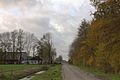
 Het Lingebos op een dag in November.jpg 4,770 × 3,177; 8.2 MB
-
 Houtkap in het Lingebos bij Vuren.jpg 4,770 × 3,177; 5.7 MB
-

-
 Lingebos Groepsschuilplaats type P nr1.JPG 3,648 × 2,736; 4.28 MB
-
 Lingebos Groepsschuilplaats type P nr2.JPG 3,648 × 2,736; 4.26 MB
-
 Lingebos Inundatiebank.JPG 3,648 × 2,736; 4.33 MB
-
 Waterplas Lingebos 2020 1.jpg 4,032 × 3,024; 4.32 MB
-
 Waterplas Lingebos 2020 2.jpg 4,032 × 3,024; 4.5 MB
-
 Zicht op het regreatiegebied het Lingebos bij Vuren.jpg 4,770 × 3,177; 7.43 MB


