Category:Lindhofscheune (Lindhof 190, Windisch)
Jump to navigation
Jump to search
| Object location | | View all coordinates using: OpenStreetMap |
|---|
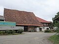
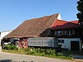
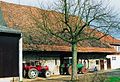
rural building in Windisch in the canton of Aargau, Switzerland  | |||||
| Upload media | |||||
| Instance of | |||||
|---|---|---|---|---|---|
| Part of | |||||
| Location | Windisch, Brugg District, Aargau, Switzerland | ||||
| Street address |
| ||||
| Heritage designation | |||||
| Inception |
| ||||
 | |||||
Media in category "Lindhofscheune (Lindhof 190, Windisch)"
The following 4 files are in this category, out of 4 total.
-
 Lindhofscheune Windisch 02.jpg 2,592 × 1,944; 1.27 MB
-
 Lindhofscheune Windisch 03.jpg 2,592 × 1,944; 1.32 MB
-
 Lindhofscheune Windisch.jpg 1,084 × 809; 253 KB
-
 Lindhofscheune.jpg 331 × 226; 67 KB


