Category:Lime Point Light
Jump to navigation
Jump to search
| Object location | | View all coordinates using: OpenStreetMap |
|---|
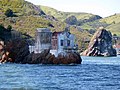
English: Lime Point Light
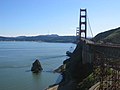
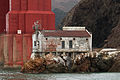
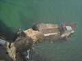
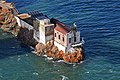
Lighthouse below the Golden Gate Bridge, California  Lime Point Lighthouse, Golden Gate strait | |||||
| Upload media | |||||
| Instance of | |||||
|---|---|---|---|---|---|
| Made from material | |||||
| Location | Marin County, California, Pacific States Region | ||||
| Service entry |
| ||||
| Inception |
| ||||
| Source of energy | |||||
 | |||||
Media in category "Lime Point Light"
The following 18 files are in this category, out of 18 total.
-
 Freighter India Bear after her 1960 ramming of Lime Point Light Station.gif 1,552 × 1,252; 1.81 MB
-
 Golden Gate Bridge (5853).JPG 1,024 × 768; 78 KB
-
 Lighthouse California-06010 - Lime Point Lighthouse (20611511026).jpg 1,920 × 1,080; 1.33 MB
-
 Lime Point Light Station (2023)-5147.jpg 5,703 × 3,802; 13.63 MB
-
 Lime Point Light Station (2023)-5152.jpg 6,000 × 4,000; 22.23 MB
-
 Lime Point Light Station beneath the Golden Gate Bridge.jpg 4,108 × 2,739; 7.58 MB
-
 Lime Point Light.jpg 1,602 × 2,922; 2.06 MB
-
 Lime Point Lighthouse (2009).jpg 3,264 × 2,448; 2.01 MB
-
 Lime Point Lighthouse, SW view.jpg 3,009 × 2,001; 6 MB
-
 Lime Point steam fog whistle equipment.jpg 1,324 × 2,121; 1.36 MB
-
 Lime Point.jpg 576 × 432; 137 KB
-
 San Francisco Lime Point Light Station.jpg 4,300 × 3,212; 5.69 MB
-
 Sausalito (CA, USA), Golden Gate Bridge Vista Point -- 2022 -- 3066.jpg 4,480 × 6,720; 13.77 MB
-
 Sausalito (CA, USA), Golden Gate Bridge Vista Point -- 2022 -- 3070.jpg 4,480 × 6,720; 14.22 MB
-
 USCGlimepoint.JPG 450 × 370; 61 KB
-
 Views from the Golden Gate Bridge 12 2017-04-01.jpg 6,000 × 4,000; 13.42 MB
-
 Views from the Golden Gate Bridge 18 2017-04-01.jpg 6,000 × 4,000; 12.86 MB
-
 Views from the Golden Gate Bridge 4 2017-04-01.jpg 6,000 × 4,000; 14.04 MB

.JPG)
.jpg)
-5147.jpg)
-5152.jpg)


.jpg)


,_Golden_Gate_Bridge_Vista_Point_--_2022_--_3066.jpg)
,_Golden_Gate_Bridge_Vista_Point_--_2022_--_3070.jpg)


Categories:
- Lighthouses in the United States by name
- Lighthouses in Marin County, California
- Lighthouses built in 1900
- Inactive lighthouses in the United States
- Golden Gate (strait)
- Brick lighthouses in the United States
- Lighthouses with focal heights, 1 to 10 metres
- Lighthouses by height, 1 to 10 meters
- 6-meter-tall structures in the United States