Category:Life expectancy maps of India
Jump to navigation
Jump to search
Media in category "Life expectancy maps of India"
The following 12 files are in this category, out of 12 total.
-
 12889 2024 18278 Fig4 HTML.webp 2,008 × 2,135; 378 KB
-
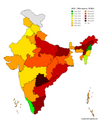
 2011-2016 Life Expectancy map for India by states.svg 1,578 × 1,738; 863 KB
-
 India-life-expectancy-2011.svg 1,486 × 1,734; 644 KB
-
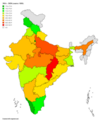
 Indian states by life expectancy (2019-21).png 1,080 × 1,080; 270 KB
-
 Life expectancy map of India by NFHS 2015-2016 with names.png 3,818 × 4,600; 1,010 KB
-
 Life expectancy map of India by NFHS 2015-2016.png 3,818 × 4,600; 702 KB
-
 Life expectancy map of India by NFHS 2019-2021 with names.png 3,818 × 4,600; 1.38 MB
-
 Life expectancy map of India by NFHS 2019-2021.png 3,818 × 4,600; 1.08 MB
-
 Life expectancy map of India by SRS 2015-2019 with names.png 3,818 × 4,600; 924 KB
-
 Life expectancy map of India by SRS 2015-2019.png 3,818 × 4,600; 1.1 MB
-
 Life expectancy map of India by SRS 2016-2020 with names.png 3,818 × 4,600; 933 KB
-
 Life expectancy map of India by SRS 2016-2020.png 3,818 × 4,600; 1.1 MB


.png)


