Category:Lievens (Rosmalen)
Jump to navigation
Jump to search
| Object location | | View all coordinates using: OpenStreetMap |
|---|
farmhouse in 's-Hertogenbosch, Netherlands  | |||||
| Upload media | |||||
| Instance of | |||||
|---|---|---|---|---|---|
| Location | Rosmalen, 's-Hertogenbosch, North Brabant, Netherlands | ||||
| Street address |
| ||||
| Located on street |
| ||||
| Heritage designation |
| ||||
 | |||||
|
This is a category about rijksmonument number 32721
|
| Address |
|
Media in category "Lievens (Rosmalen)"
The following 25 files are in this category, out of 25 total.
-
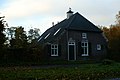 Boerderij Waterleidingstraat-Kruisstraat.JPG 3,008 × 2,000; 1.11 MB
-
 Exterieur achtergevel - Rosmalen - 20001246 - RCE.jpg 1,190 × 1,200; 508 KB
-
 Exterieur detail linkerzijgevel - Rosmalen - 20001248 - RCE.jpg 1,188 × 1,200; 352 KB
-
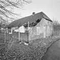
 Exterieur overzicht boerderij - Rosmalen - 20001243 - RCE.jpg 1,183 × 1,200; 477 KB
-
 Exterieur overzicht linkerzijgevel - Rosmalen - 20001245 - RCE.jpg 1,179 × 1,200; 513 KB
-
 Exterieur overzicht rechterzijgevel - Rosmalen - 20001247 - RCE.jpg 1,179 × 1,200; 459 KB
-
 Exterieur voorgevel en linkerzijgevel - Rosmalen - 20001244 - RCE.jpg 1,185 × 1,200; 448 KB
-
 Interieur, boerderij muurschildering in de gang - Rosmalen - 20001258 - RCE.jpg 1,176 × 1,200; 283 KB
-
 Interieur, boerderij muurschildering in de gang - Rosmalen - 20001259 - RCE.jpg 1,188 × 1,200; 264 KB
-

-
 Interieur, boerderij, kelder - Rosmalen - 20001265 - RCE.jpg 1,196 × 1,200; 298 KB
-
 Interieur, boerderij, kleine kamer - Rosmalen - 20001264 - RCE.jpg 1,185 × 1,200; 265 KB
-
 Interieur, boerderij, overzicht gang - Rosmalen - 20001263 - RCE.jpg 1,125 × 1,200; 246 KB
-
 Interieur, boerderij, woonkamer - Rosmalen - 20001266 - RCE.jpg 1,184 × 1,200; 397 KB
-
 Interieur, brandmuur - Rosmalen - 20001257 - RCE.jpg 1,183 × 1,200; 453 KB
-
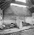
 Interieur, overzicht ruimte achter de varkenskotten - Rosmalen - 20001253 - RCE.jpg 1,179 × 1,200; 353 KB
-
 Interieur, overzicht ruimte achter de varkenskotten - Rosmalen - 20001254 - RCE.jpg 1,181 × 1,200; 322 KB
-
 Interieur, overzicht varkenskot - Rosmalen - 20001252 - RCE.jpg 1,190 × 1,200; 329 KB
-
 Interieur, overzicht varkenskotten met troggen - Rosmalen - 20001255 - RCE.jpg 1,183 × 1,200; 384 KB
-
 Interieur, overzicht varkenskotten met troggen - Rosmalen - 20001256 - RCE.jpg 1,200 × 1,195; 408 KB
-
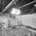
 Interieur, varkenskot, kapconstructie - Rosmalen - 20001261 - RCE.jpg 1,188 × 1,200; 365 KB
-
 Interieur, varkenskot, overzicht kapconstructie - Rosmalen - 20001262 - RCE.jpg 1,200 × 1,183; 305 KB
-
 Interieur, varkenskotten - Rosmalen - 20001249 - RCE.jpg 1,181 × 1,200; 365 KB
-
 Interieur, varkenskotten - Rosmalen - 20001250 - RCE.jpg 1,192 × 1,200; 346 KB
-
 Interieur, varkenskotten - Rosmalen - 20001251 - RCE.jpg 1,178 × 1,200; 336 KB


