Category:Liebfrauenkapelle Rapperswil
Jump to navigation
Jump to search
| Object location | | View all coordinates using: OpenStreetMap |
|---|
church building in Canton of St. Gallen, Switzerland  | |||||
| Upload media | |||||
| Instance of | |||||
|---|---|---|---|---|---|
| Dedicated to | |||||
| Location | canton St. Gallen, Switzerland | ||||
| Inception |
| ||||
| Religion or worldview | |||||
| official website | |||||
 | |||||
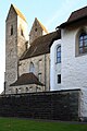
Deutsch: Nordwestlich der Pfarrkirche St. Johann und östlich des Schlosses befindet sich die Liebfrauenkapelle (1489 erbaut), darunter das Beinhaus aus dem Jahr 1253, als Rapperswil selbständige Pfarrei wurde und einen Friedhof erhielt.
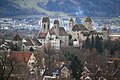
English: Liebfrauenkapelle (St. Mary's Chapel) is located in Rapperswil in Switzerland and is the cemetery chapel of Pfarrkirche St. Johann (St. John's Church). The small church dates back to the ossuary next to the castle and was built by the House of Rapperswil around 1253 AD.
Subcategories
This category has only the following subcategory.
Media in category "Liebfrauenkapelle Rapperswil"
The following 61 files are in this category, out of 61 total.
-
 CH Rapperswil-Jona, Liebfrauenkapelle 001.jpg 3,024 × 4,032; 1.78 MB
-
 CH Rapperswil-Jona, Liebfrauenkapelle 002.jpg 3,024 × 4,032; 613 KB
-
 CH Rapperswil-Jona, Liebfrauenkapelle 003.jpg 2,972 × 3,963; 2.23 MB
-
 CH Rapperswil-Jona, Liebfrauenkapelle 004.jpg 4,032 × 3,024; 1.81 MB
-

-
 Kempraten - Bachtel - Liebfrauenkapelle - Schloss Rapperswil 2012-09-23 15-48-01 (P7000).JPG 3,648 × 2,736; 3.63 MB
-
 Liebfauenkapelle - Stadtpfarrkirche Rapperswil 2011-03-11 15-53-44 ShiftN.jpg 4,088 × 2,725; 2.32 MB
-

-

-
 Liebfrauenkapelle - Mariensäule Rapperswil 2011-07-02 14-41-42 ShiftN2.jpg 2,544 × 3,821; 2.18 MB
-
 Liebfrauenkapelle - Rapperswil Friedhof 2011-08-13 15-49-50 ShiftN2.jpg 2,642 × 3,523; 2.55 MB
-
 Liebfrauenkapelle - Rapperswil Friedhof 2011-08-13 15-50-00 ShiftN2.jpg 4,000 × 2,667; 2.62 MB
-
 Liebfrauenkapelle - Stadtpfarrkirche 2012-11-04 13-26-17.JPG 3,264 × 4,928; 9.1 MB
-
 Liebfrauenkapelle - Stadtpfarrkirche 2012-11-04 13-27-11.JPG 3,264 × 4,928; 7.15 MB
-
 Liebfrauenkapelle - Stadtpfarrkirche 2012-11-04 13-30-40.JPG 4,800 × 3,200; 3.88 MB
-
 Liebfrauenkapelle - Stadtpfarrkirche Rapperswil 2011-06-19 14-58-54 ShiftN2.jpg 2,628 × 3,942; 2.31 MB
-
 Liebfrauenkapelle - Stadtpfarrkirche Rapperswil 2012-11-01 14-29-23.jpg 2,999 × 4,500; 3.42 MB
-
 Liebfrauenkapelle -Rapperswil Schloss 2011-03-12 16-35-22.JPG 2,772 × 4,176; 3.08 MB
-
 Liebfrauenkapelle -Rapperswil Schloss 2011-03-12 16-37-42 ShiftN.jpg 2,425 × 3,638; 2.84 MB
-
 Liebfrauenkapelle 2011-06-25 15-55-52 ShiftN.jpg 2,714 × 4,080; 2.22 MB
-
 Liebfrauenkapelle in Rapperswil.jpg 1,200 × 800; 883 KB
-
 Liebfrauenkapelle Rapperswil - Friedhof 2011-01-21 16-44-06 ShiftN.jpg 3,616 × 2,714; 2 MB
-
 Liebfrauenkapelle Rapperswil - Stadtpfarrkirche 2012-12-31 12-59-45.JPG 3,240 × 4,320; 3.04 MB
-
 Liebfrauenkapelle Rapperswil - Stadtpfarrkirche 2012-12-31 13-00-24.JPG 3,200 × 4,800; 3.32 MB
-

-

-
 Rapperswil , Switzerland - panoramio (19).jpg 4,272 × 2,848; 10.25 MB
-
 Rapperswil , Switzerland - panoramio (21).jpg 2,848 × 4,272; 7.55 MB
-
 Rapperswil - Liebfrauenkapelle - Schloss IMG 4844.JPG 3,672 × 2,754; 2.57 MB
-
 Rapperswil - Liebfrauenkapelle - Schloss Kräutergarten 2011-08-06 15-08-24.jpg 2,848 × 4,288; 1.39 MB
-
 Rapperswil - Liebfrauenkapelle - St Johann IMG 4850 ShiftN.jpg 3,879 × 2,586; 2.58 MB
-
 Rapperswil - Liebfrauenkapelle IMG 2089.JPG 2,592 × 3,888; 5.36 MB
-
 Rapperswil - Liebfrauenkapelle IMG 2090.JPG 2,653 × 3,537; 2.41 MB
-
 Rapperswil - Liebfrauenkapelle IMG 3102 ShiftN.jpg 2,773 × 4,161; 3.19 MB
-
 Rapperswil - Liebfrauenkapelle IMG 3105 ShiftN.jpg 2,475 × 3,980; 2.61 MB
-
 Rapperswil - Liebfrauenkapelle IMG 4851.JPG 2,725 × 4,089; 2.01 MB
-
 Rapperswil - Liebfrauenkapelle IMG 6894 ShiftN.jpg 2,382 × 3,575; 1.16 MB
-
 Rapperswil - Liebfrauenkapelle IMG 6899 ShiftN.jpg 2,351 × 3,527; 1.42 MB
-
 Rapperswil - Liebfrauenkapelle IMG 6900 ShiftN.jpg 3,361 × 2,520; 1.56 MB
-
 Rapperswil - Liebfrauenkapelle IMG 6905.JPG 2,675 × 4,017; 2.53 MB
-
 Rapperswil - Liebfrauenkapelle IMG 6908 ShiftN.jpg 2,374 × 3,563; 1.58 MB
-
 Rapperswil - Liebfrauenkapelle IMG 6911 ShiftN.jpg 2,537 × 3,806; 1.78 MB
-
 Rapperswil - Liebfrauenkapelle-Schlossberg IMG 4128 ShiftN.jpg 2,719 × 4,075; 1.98 MB
-
 Rapperswil - Liebfrauenkapelle-Stadtpfarrkirche IMG 5640 ShiftN.jpg 2,739 × 4,112; 3.75 MB
-
 Rapperswil - Liebfrauenkapelle-Stadtpfarrkirche IMG 5643 ShiftN.jpg 2,287 × 3,049; 2.13 MB
-
 Rapperswil - panoramio (4).jpg 4,303 × 5,512; 11.73 MB
-
 Rapperswil - Schloss-Stadtpfarrkirche - Lenggisrain IMG 9427.jpg 3,784 × 2,522; 2.25 MB
-
 Rapperswil - Schloss-Stadtpfarrkirche - Meienberg IMG 9064.jpg 3,888 × 2,592; 4.9 MB
-
 Rapperswil - Schloss-Stadtpfarrkirche - Meienberg IMG 9076.jpg 3,888 × 2,592; 4 MB
-
 Rapperswil - Schloss-Stadtpfarrkirche - Meienberg IMG 9082.jpg 3,784 × 2,522; 2.12 MB
-
 Rapperswil - Schloss-Stadtpfarrkirche - Meienberg IMG 9109.jpg 3,888 × 2,592; 4.43 MB
-
 Rapperswil - St Johann & Liebfrauenkapelle IMG 4122 ShiftN.jpg 3,966 × 2,641; 2.67 MB
-
 Rapperswil - Stadtmuseum-Herrenberg-Stadtpfarrkirche-Schloss - Jona Rüssel IMG 4957.JPG 3,264 × 2,448; 2.61 MB
-
 Rapperswil - Stadtpfarrkirche - Liebfrauenkapelle 2010-06-11 18-38-24 ShiftN.jpg 3,661 × 2,746; 2.55 MB
-
 Rapperswil - Stadtpfarrkirche - Liebfrauenkapelle IMG 2435 ShiftN.jpg 2,046 × 3,069; 4.9 MB
-
 Rapperswil - Stadtpfarrkirche 20080222 017 ShiftN.jpg 2,182 × 1,637; 3.38 MB
-
 Rapperswil - Stadtpfarrkirche IMG 1752 ShiftN.jpg 2,104 × 1,578; 2.71 MB
-
 Rapperswil - Stadtpfarrkirche IMG 3112 ShiftN.jpg 3,220 × 2,415; 2 MB
-
 Rapperswil - Stadtpfarrkirche Marienkapelle lMG 0358 ShiftN.jpg 3,707 × 2,471; 2.45 MB
-
 Rapperswil - Stadtpfarrkirche und Liebfrauenkapelle.jpg 2,256 × 3,008; 1.47 MB
-
 Rapperswil-Jona, kapel foto3 2014-07-19 14.12.jpg 4,062 × 3,048; 7.28 MB


.JPG)


.jpg)
.jpg)


.jpg)


