Category:Lewisian Gneiss
Jump to navigation
Jump to search
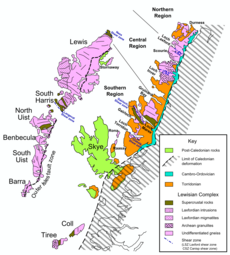
suite of Precambrian metamorphic rocks that outcrop in the northwestern part of Scotland | |||||
| Upload media | |||||
| Instance of | |||||
|---|---|---|---|---|---|
| Location | Scotland | ||||
| |||||
Subcategories
This category has the following 16 subcategories, out of 16 total.
*
- Corodale Gneiss (2 F)
+
- Lewisian Gneiss - maps (4 F)
A
- Assyntian Unconformity (5 F)
B
- Badcallian Gneiss (2 F)
- Ben More Assynt (27 F)
F
H
- Haskeir (12 F)
P
Q
- Quinag (62 F)
R
S
- Sule Skerry (8 F)
Media in category "Lewisian Gneiss"
The following 131 files are in this category, out of 131 total.
-
A 2000 million year old rock.jpg 4,032 × 3,024; 4.51 MB
-
A Scourie Dyke - geograph.org.uk - 833049.jpg 507 × 640; 346 KB
-
Aird da Loch Peninsula - geograph.org.uk - 189578.jpg 640 × 384; 84 KB
-
Aird da Loch Peninsula - geograph.org.uk - 189579.jpg 640 × 384; 92 KB
-
Angewitterter Lewis-Gneis an der Westküste von Great Bernera II.jpg 5,184 × 3,456; 10.9 MB
-
Angewitterter Lewis-Gneis an der Westküste von Great Bernera.jpg 5,184 × 3,456; 11.12 MB
-
Austernfischer auf Great Bernera.jpg 5,184 × 3,456; 6.3 MB
-
Basalt dyke below Aird Mheadhonach - geograph.org.uk - 1462846.jpg 640 × 427; 137 KB
-
Beach Inlet - geograph.org.uk - 1363169.jpg 480 × 640; 278 KB
-
Bhatarsaigh Causeway Quarry - geograph.org.uk - 1364312.jpg 640 × 480; 335 KB
-
Blick über die Gneisfelsen des Beinn Sciathan nach Westnordwest.jpg 5,166 × 3,429; 9.27 MB
-
Bàgh Blàsguidh from Rubha Ghriminis - geograph.org.uk - 1350262.jpg 640 × 480; 286 KB
-
Cairn south of Beinn na h-Iolaire - geograph.org.uk - 923026.jpg 640 × 479; 232 KB
-
Cnoc Gorm and Unnamed Lochan - geograph.org.uk - 820395.jpg 640 × 427; 255 KB
-
Cnoca Breac - geograph.org.uk - 1370176.jpg 640 × 480; 246 KB
-
Crag, Beinn Conchra - geograph.org.uk - 1601216.jpg 640 × 480; 116 KB
-
Crags above Lochan nam Meallan - geograph.org.uk - 821571.jpg 640 × 427; 271 KB
-
Detail Gneisaufschluss Küste Balranald-Vogelschutzgebiet.jpg 5,184 × 3,456; 9.53 MB
-
Doppelwand des Brochs Dun Carloway, Lewis.jpg 5,184 × 3,456; 8.75 MB
-
Exemplar der Callanish Stones.jpg 3,456 × 5,184; 8.26 MB
-
Felspartie auf Great Bernera.jpg 5,184 × 3,456; 7.22 MB
-
Felswatt mit Lewis-Gneis, Great Bernera.jpg 5,184 × 3,456; 9.39 MB
-
Folds on the Foreshore - geograph.org.uk - 1343679.jpg 640 × 358; 250 KB
-
Gearraidh a Siar - geograph.org.uk - 1351452.jpg 640 × 427; 274 KB
-
Gebänderter Gneis am Strand des Balranald-Vogelschutzgebiets, North Uist.jpg 5,184 × 3,456; 7.58 MB
-
Geröll aus Lewis-Gneis an der Küste von Great Bernera.jpg 5,184 × 3,456; 11.15 MB
-
Glencoul Thrust - geograph.org.uk - 823646.jpg 640 × 337; 211 KB
-
Gletscherschliff Harris.jpg 5,184 × 3,456; 6.84 MB
-
Gneis im Gebiet zwischen dem Gearrannan Blackhouse Village und Dalmore Beach.jpg 5,184 × 3,456; 9.37 MB
-
Gneis in der Brandungszone und Geröll, Balranald-Vogelschutzgebiet.jpg 5,184 × 3,456; 15.08 MB
-
Gneis mit kleinräumigen Verformungen, Westküste von Great Bernera II.jpg 5,184 × 3,456; 12.32 MB
-
Gneis mit kleinräumigen Verformungen, Westküste von Great Bernera.jpg 5,184 × 3,456; 10.84 MB
-
Gneisaufschluss in der Brandungszone, Balranald-Vogelschutzgebiet.jpg 5,184 × 3,456; 11.14 MB
-
Gneiss - geograph.org.uk - 1379172.jpg 640 × 480; 314 KB
-
Gneiss at Tràigh-Stir - geograph.org.uk - 1351215.jpg 427 × 640; 232 KB
-
Gneiss at Uig Sands, Lewis - geograph.org.uk - 1205538.jpg 436 × 640; 71 KB
-
Gneissoutcroprona.jpg 640 × 427; 95 KB
-
Großer Felsblock, Harris nahe des Weges zwischen Aird Mhige und Seilebost.jpg 5,184 × 3,456; 9.67 MB
-
Iona Abbey and Dun I (16509956261).jpg 2,964 × 1,048; 1.02 MB
-
Kies am Strand Bagh A'Deas.jpg 1,260 × 882; 1.01 MB
-
Kleinräumig verformter Lewis-Gneis mit vermutlich magmatischen Intrusionen.jpg 5,184 × 3,456; 10.44 MB
-
Küste von Great Bernera zwischen Valasay und Bostadh.jpg 5,184 × 3,456; 10.25 MB
-
Küstenpartie im Balranald-Vogelschutzgebiet II.jpg 5,184 × 3,456; 10.31 MB
-
Küstenpartie im Balranald-Vogelschutzgebiet, North Uist.jpg 5,107 × 3,341; 12.08 MB
-
Küstenpartie im Balranald-Vogelschutzgebiet.jpg 5,154 × 3,411; 11.66 MB
-
Landschaft im Nordwesten von Lewis.jpg 5,184 × 3,456; 8.18 MB
-
Landschaft im Südteil von Harris zwischen Aird Mhige und Seilebost II.jpg 5,184 × 3,456; 6.71 MB
-
Landschaft im Südteil von Harris zwischen Aird Mhige und Seilebost.jpg 5,184 × 3,456; 6.66 MB
-
Lewis-Gneis mit Verformungen im Dezimeter-Bereich, Westküste von Great Bernera.jpg 5,184 × 3,456; 10.81 MB
-
Lewisian Gneiss - geograph.org.uk - 1346808.jpg 484 × 640; 308 KB
-
Lewisian Gneiss - geograph.org.uk - 1346848.jpg 640 × 417; 258 KB
-
Lewisian Gneiss - geograph.org.uk - 1346856.jpg 427 × 640; 267 KB
-
Lewisian Gneiss - geograph.org.uk - 1346868.jpg 427 × 640; 263 KB
-
Lewisian Gneiss - geograph.org.uk - 1348829.jpg 536 × 640; 315 KB
-
Lewisian Gneiss - geograph.org.uk - 1348844.jpg 427 × 640; 276 KB
-
Lewisian Gneiss - geograph.org.uk - 1350254.jpg 480 × 640; 303 KB
-
Lewisian Gneiss - geograph.org.uk - 1370208.jpg 480 × 640; 352 KB
-
Lewisian Gneiss - geograph.org.uk - 1470652.jpg 640 × 427; 118 KB
-
Lewisian Gneiss - geograph.org.uk - 1525319.jpg 640 × 480; 94 KB
-
Lewisian Gneiss - geograph.org.uk - 155359.jpg 640 × 425; 273 KB
-
Lewisian Gneiss - geograph.org.uk - 2002581.jpg 640 × 480; 87 KB
-
Lewisian Gneiss - geograph.org.uk - 3003701.jpg 640 × 424; 332 KB
-
Lewisian Gneiss - geograph.org.uk - 486896.jpg 480 × 640; 125 KB
-
Lewisian Gneiss - geograph.org.uk - 821517.jpg 640 × 427; 328 KB
-
Lewisian Gneiss - geograph.org.uk - 821552.jpg 640 × 427; 110 KB
-
Lewisian Gneiss - geograph.org.uk - 821582.jpg 640 × 427; 250 KB
-
Lewisian Gneiss - Rhiconich, Scotland.jpg 6,440 × 2,767; 15.52 MB
-
Lewisian Gneiss at Hougharry on North Uist in Scotland.jpg 1,500 × 910; 456 KB
-
Lewisian Gneiss on Raasay in Scotland - geograph 6173260.jpg 1,280 × 850; 781 KB
-
Lewisian Gneiss, Achmelvich Bay.jpg 4,608 × 2,592; 3.5 MB
-
Lewisian Gneiss, Butt of Lewis - geograph.org.uk - 588498.jpg 640 × 412; 272 KB
-
Lewisian Rocks on Tràigh na h-Uamhag - geograph.org.uk - 822081.jpg 640 × 417; 252 KB
-
Lewisian Rocks on Tràigh na h-Uamhag - geograph.org.uk - 822088.jpg 473 × 640; 262 KB
-
Lewisian Rocks on Tràigh na h-Uamhag - geograph.org.uk - 822103.jpg 640 × 427; 226 KB
-
Lewisian-Torridonian Unconformity - geograph.org.uk - 9020.jpg 640 × 421; 275 KB
-
Lewissian Gneiss Boulder.jpg 640 × 426; 74 KB
-
Ligusticum scoticum im Balranald-Vogelschutzgebiet.jpg 5,184 × 3,456; 9.44 MB
-
Lochinver, gneiss quarry near the port.jpg 3,648 × 2,736; 2.45 MB
-
Looking north from Mor Eilean - geograph.org.uk - 1202979.jpg 640 × 282; 62 KB
-
Meall Acairseid - geograph.org.uk - 715200.jpg 640 × 384; 69 KB
-
Meall Dearg - geograph.org.uk - 923016.jpg 640 × 427; 211 KB
-
Millennium Rock - geograph.org.uk - 1580264.jpg 640 × 426; 158 KB
-
Moine Thrust in Allt Duisdale - geograph.org.uk - 1427090.jpg 640 × 480; 120 KB
-
Near Loch Buaile Cairistiona Mhurchaidh - geograph.org.uk - 1349375.jpg 640 × 427; 240 KB
-
Near Lochan nam Meallan - geograph.org.uk - 821578.jpg 640 × 427; 272 KB
-
Outcrop behind Scourie - geograph.org.uk - 1146557.jpg 480 × 640; 129 KB
-
Outcrop of Lewisian Gneiss - geograph.org.uk - 2271359.jpg 2,592 × 1,944; 1.71 MB
-
Point of Sleat Automatic Light - geograph.org.uk - 3049817.jpg 1,200 × 928; 294 KB
-
Quarzader zwischen Gneis, Great Bernera.jpg 5,184 × 3,456; 8.68 MB
-
Road Cutting - geograph.org.uk - 820828.jpg 640 × 427; 277 KB
-
Rocks on Bagh Dhail Mòr - geograph.org.uk - 750484.jpg 640 × 480; 138 KB
-
Rote Kristalle an Lewis-Gneis, Great Bernera, Nahaufnahme.jpg 5,184 × 3,456; 6.87 MB
-
Rote Kristalle an Lewis-Gneis, Great Bernera.jpg 5,184 × 3,456; 9.57 MB
-
Rubh' an Tiompain - geograph.org.uk - 820423.jpg 603 × 640; 369 KB
-
Rubha a'Mhill Ghlaise - geograph.org.uk - 821490.jpg 640 × 419; 264 KB
-
Rubha Mhànais - geograph.org.uk - 1351245.jpg 640 × 427; 270 KB
-
Rötlich gefärbtes Mineral an Lewis-Gneis, Strand bei Bostadh.jpg 5,184 × 3,456; 10.21 MB
-
Schafe auf Gletscherschliff, Harris.jpg 5,184 × 3,456; 8.72 MB
-
Schwarzes Ganggestein neben Lewis-Gneis am Ufer des Balranald-Vogelschutzgebiets.jpg 5,184 × 3,456; 8.74 MB
-
Scolpaig Bay, Loch Scolpaig and Beinn Scolpaig, North Uist.jpg 4,000 × 2,250; 2.25 MB
-
Sea cave at Sloc Rubha, Scolpaig, North Uist.jpg 4,000 × 2,250; 2.61 MB
-
Sea stacks at Garry Beach, Tolsta - geograph.org.uk - 2706964.jpg 2,542 × 1,429; 828 KB
-
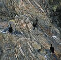
Shags, Isle of Lewis, Hebrides, Scotland (1186335164).jpg 1,280 × 1,253; 458 KB
-
Shear Zone in Lewisian Gneiss - geograph.org.uk - 1364290.jpg 480 × 640; 321 KB
-
Skerryvore lighthouse - landing jetty and hard (geograph 6888664).jpg 1,655 × 1,000; 1.14 MB
-
Sloc Rubha, Scolpaig, North Uist 01.jpg 4,000 × 2,250; 2.68 MB
-
Small Sandy Inlet, Clachtoll Bay - geograph.org.uk - 238195.jpg 640 × 480; 90 KB
-
Stac an Tuill, Bearasaigh, Isle of Lewis - geograph.org.uk - 1462900.jpg 640 × 427; 141 KB
-
Stone portrait, Callanish - geograph.org.uk - 1260027.jpg 480 × 640; 116 KB
-
Suaineabhal Summit - geograph.org.uk - 882574.jpg 640 × 428; 100 KB
-
Südliches Harris, Gletscherschliff, davor vermutlich Moränen.jpg 5,184 × 3,456; 8.87 MB
-
Taransay - Buaileabhal from Ard Mhanais - geograph.org.uk - 467018.jpg 640 × 428; 169 KB
-
The Knockan Wall - geograph.org.uk - 824976.jpg 640 × 427; 286 KB
-
Tràigh na h-Uamhag - geograph.org.uk - 822068.jpg 640 × 417; 232 KB
-
Welle im Gneis an der Westküste von Great Bernera.jpg 5,184 × 3,456; 9.41 MB
-
West coast of Rona - geograph.org.uk - 787643.jpg 640 × 427; 109 KB
-
Above Loch Eilean na Craoibhe Mòire - geograph.org.uk - 1146569.jpg 640 × 480; 114 KB
-
Boulders Near Innis Bhuidhe - geograph.org.uk - 530096.jpg 640 × 427; 84 KB
-
Cross-section of rock - geograph.org.uk - 500306.jpg 640 × 480; 181 KB
-
Geodh' Dearg - geograph.org.uk - 2903.jpg 511 × 346; 163 KB
-
Lewisian Gneiss - geograph.org.uk - 563070.jpg 427 × 640; 317 KB
-
Lower slopes of Beinn Ra - geograph.org.uk - 19366.jpg 454 × 294; 26 KB
-
Mixed rocks at the Bay of Stoer - geograph.org.uk - 61676.jpg 640 × 480; 70 KB
-
On the southwest ridge of Glas Bheinn - geograph.org.uk - 158517.jpg 640 × 480; 119 KB
-
Rocks on the shore, Port Mhor Bhragair. - geograph.org.uk - 503133.jpg 640 × 480; 135 KB
-
Rubha Robhanais - geograph.org.uk - 203992.jpg 640 × 389; 223 KB
-
Sron Romul - geograph.org.uk - 19121.jpg 456 × 293; 20 KB
-
Typical Lewisian Gneiss Landscape - geograph.org.uk - 155361.jpg 640 × 425; 223 KB
Categories:
- Gneiss formations
- Geology of Ross and Cromarty
- Geology of Skye and Lochalsh
- Sutherland
- Precambrian geology of Scotland
- Geology of the Outer Hebrides
- Geologic groups of Scotland
- Gneiss in Scotland
- Gneiss formations in Scotland
- Precambrian metamorphic rocks in Scotland
- Precambrian igneous rocks in Scotland
- Archean geology of Scotland
- Archean metaigneous rocks in Scotland
- Granitic rocks in Scotland
- Geology of the Isle of Skye
- Lewisian Complex
- Lewisian Basement rocks
- Archean formations in Scotland
- Geologic formations in Scotland


