Category:Letterfearn
Jump to navigation
Jump to search
English: Letterfearn is a settlement that lies of the western shore of Loch Duich in Skye and Lochalsh, Ross-shire, Scottish Highlands and is in the Scottish council area of Highland.
human settlement in Highland, Scotland, UK | |||||
| Upload media | |||||
| Instance of | |||||
|---|---|---|---|---|---|
| Location |
| ||||
 | |||||
Media in category "Letterfearn"
The following 25 files are in this category, out of 25 total.
-
 Houses at Letterfearn - geograph.org.uk - 893996.jpg 640 × 480; 78 KB
-
 Jetty at fish farm on west side of Loch Shiel - geograph.org.uk - 2969917.jpg 1,500 × 843; 1.59 MB
-
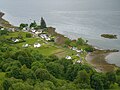 Letterfearn - geograph.org.uk - 2468077.jpg 4,000 × 3,000; 6.39 MB
-
 Letterfearn shoreline - geograph.org.uk - 3691419.jpg 1,024 × 683; 1.21 MB
-
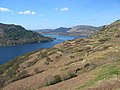
 Loch Duich - geograph.org.uk - 5586014.jpg 1,024 × 683; 240 KB
-
 Loch Duich from Lettefearn - geograph.org.uk - 8502.jpg 640 × 395; 80 KB
-
 Minor road through Letterfearn - geograph.org.uk - 2399383.jpg 1,000 × 664; 305 KB
-
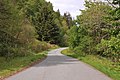 Minor road to Letterfearn - geograph.org.uk - 2399348.jpg 1,000 × 664; 449 KB
-
 Moorland above Letterfearn with Beinn a' Chuirn beyond - geograph.org.uk - 2468023.jpg 4,000 × 3,000; 5.78 MB
-
 Shore of Loch Duich at Letterfearn - geograph.org.uk - 2968685.jpg 1,500 × 1,125; 1.69 MB
-
 Beolary Farm in Glen More - geograph.org.uk - 546184.jpg 640 × 480; 95 KB
-
 Braeside Farm - geograph.org.uk - 212553.jpg 640 × 480; 70 KB
-
 Carr Brae - geograph.org.uk - 406274.jpg 640 × 480; 269 KB
-
 Cottage by road, on lochside - geograph.org.uk - 487840.jpg 640 × 480; 136 KB
-
 Fish Farm on Loch Duich - geograph.org.uk - 212148.jpg 640 × 480; 90 KB
-
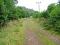 Forestry Track - geograph.org.uk - 212144.jpg 640 × 480; 132 KB
-
 Glen More, Glenelg - geograph.org.uk - 8436.jpg 601 × 377; 119 KB
-
 Loch Duich near Drudaig Lodge - geograph.org.uk - 487829.jpg 640 × 480; 151 KB
-

-

-
 Road to Totaig - geograph.org.uk - 546249.jpg 640 × 480; 161 KB
-
 Salmon fishery in Loch Duich - geograph.org.uk - 487848.jpg 640 × 480; 113 KB
-
 Secluded Crofthouse - geograph.org.uk - 212151.jpg 640 × 480; 123 KB
-
 Sgurr Aoide - geograph.org.uk - 406223.jpg 640 × 480; 325 KB
-
 The Forest Edge above Moyle - geograph.org.uk - 374885.jpg 640 × 480; 126 KB


