Category:Les Torres de Cas
Jump to navigation
Jump to search
| Object location | | View all coordinates using: OpenStreetMap |
|---|
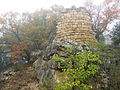
cultural property in Àger, Spain  | |||||
| Upload media | |||||
| Instance of | |||||
|---|---|---|---|---|---|
| Location | Àger, Noguera, Ponent, Province of Lleida, Catalonia | ||||
| Street address |
| ||||
| Heritage designation | |||||
| Inception |
| ||||
| Elevation above sea level |
| ||||
 | |||||
Català: Les Torres de Cas (Àger)
This is a category about a monument listed in the Catalan heritage register of Béns Culturals d'Interès Nacional and the Spanish heritage register of Bienes de Interés Cultural under the reference RI-51-0006201. |
Media in category "Les Torres de Cas"
The following 2 files are in this category, out of 2 total.
-
 Cas-IMG 6556.JPG 2,816 × 2,112; 2.22 MB
-
 Cas-IMG 6565.JPG 2,816 × 2,112; 1.86 MB
