Category:Les Menuires
Jump to navigation
Jump to search
| Camera location | | View all coordinates using: OpenStreetMap |
|---|
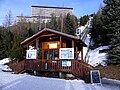
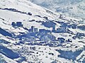
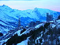
Nederlands: Pictures of Les Menuires (1450 tot 2850 m) a village and ski resort belongs to the municipality Saint-Martin-de-Belleville in the French Alps in the Belleville valley and Tarentaise Valley in the departement Savoie in France. Les Menuires consists of Les Bruyères, Grand Reberty, Les Fontanettes, La Croisette and Preyerand.
Les Menuires is a part of the big ski region Les 3 Vallées (Les Trois Vallées) from what Courchevel (opened in 1946), Méribel (1939), Les Menuires (1964) and Val Thorens (1972) are the greatest, connected in 1973. Les 3 Vallées have about 600 km (370 mi) of ski slopes and 183 ski lifts. Les Trois Vallées is the largest connected ski area in the world
Nederlands: Afbeeldingen van Les Menuires (1450 tot 2850 m) een dorp en skigebied behorende tot de gemeente Saint-Martin-de-Belleville in de Franse Alpen in de Vallée des Belleville en Tarentaisevallei in het departement Savoie in Frankrijk. Les Menuires bestaat onder meer uit Les Bruyères, Grand Reberty, Les Fontanettes, La Croisette en Preyerand.
Les Menuires is een deel van het grote wintersportgebied Les 3 Vallées (Les Trois Vallées) waarvan Courchevel (geopend in 1946), Méribel (1939), Les Menuires (1964) en Val Thorens (1972) de grootste zijn, die in 1973 met elkaar verbonden werden. Les 3 Vallées kan beschouwd worden als 's werelds grootste aaneengesloten wintersportgebied.
ski resort  | |||||
| Upload media | |||||
| Instance of | |||||
|---|---|---|---|---|---|
| Part of | |||||
| Location | Savoie, Auvergne-Rhône-Alpes, Metropolitan France, France | ||||
| Mountain range | |||||
| official website | |||||
 | |||||
Subcategories
This category has the following 5 subcategories, out of 5 total.
Media in category "Les Menuires"
The following 52 files are in this category, out of 52 total.
-
 2014 Val-Thorens Luyten-De-Hauwere 04.jpg 2,592 × 1,936; 1.89 MB
-
 Belleville Valley from Tougnète.jpg 3,008 × 1,755; 3.82 MB
-
 Doron de Belleville aux Menuires depuis télébenne (janvier 2024).JPG 3,264 × 2,448; 3.58 MB
-
 Front de neige de la station des Menuires (janvier 2024).JPG 3,264 × 2,448; 3.71 MB
-
 Front de neige et village de la station des Menuires (janvier 2024).JPG 3,224 × 2,416; 4.06 MB
-
 Gare d'arrivée Télécaine Pointe de la Masse aux Menuires (janvier 2024).JPG 3,264 × 2,448; 2.79 MB
-
 L'ascenseur public Brelin aux Menuires (janvier 2024) 1.JPG 3,264 × 2,448; 3.5 MB
-
 L'ascenseur public Brelin aux Menuires (janvier 2024) 2.JPG 3,264 × 2,448; 4.47 MB
-
 L'ascenseur public Brelin aux Menuires (janvier 2024) 3.JPG 3,264 × 2,448; 6 MB
-
 Les 3 Vallées, Les Ménuires - panoramio (5).jpg 4,608 × 3,456; 5.94 MB
-
 Les 3 Vallées, Les Ménuires - panoramio (6).jpg 4,370 × 3,110; 8.25 MB
-
 Les 3 Vallées, Les Ménuires - panoramio.jpg 4,608 × 3,456; 8.61 MB
-
 Les Menuires (cropped).JPG 2,800 × 400; 648 KB
-
 Les Menuires cabinelift.jpg 470 × 621; 101 KB
-
 Les Menuires depuis Valmorel (2015).JPG 3,040 × 2,262; 2.96 MB
-
 Les Menuires en bleu.jpg 2,288 × 1,712; 692 KB
-
 Les Menuires en Mont Blanc (Vanaf Pointe de la Masse) 2.JPG 4,320 × 3,240; 5.04 MB
-
 Les Menuires I79304.jpg 1,600 × 1,280; 384 KB
-
 Les Menuires I79320.jpg 1,600 × 1,280; 768 KB
-
 Les Menuires logo.jpg 480 × 640; 114 KB
-
 Les Menuires view from La Masse - panoramio.jpg 2,272 × 1,704; 1.02 MB
-
 Les Menuires vues du bas de Val Thorens en hiver (2019).JPG 4,000 × 3,000; 6.69 MB
-
 Les Menuires, panorama (2014).JPG 3,585 × 2,659; 4.07 MB
-
 Les Menuires, panorama (2016).JPG 3,072 × 2,304; 2.7 MB
-
 Les Menuires, station (2014).JPG 4,078 × 3,061; 7.14 MB
-
 Les menuires.jpg 800 × 452; 51 KB
-
 Les Menuires.JPG 3,072 × 2,304; 3.22 MB
-
 LesMenuires 2.JPG 2,048 × 1,536; 818 KB
-
 LesMenuires.jpg 640 × 480; 53 KB
-
 Logo Les Menuires.jpg 1,966 × 1,966; 2.31 MB
-
 Ouest de la Cime de Caron enneigé en hiver (février 2024).JPG 4,000 × 3,000; 6.15 MB
-
 Panoramique Val Thorens, hiver 2016.JPG 4,188 × 3,148; 4.77 MB
-
 Piste de ski au villages des Menuires (janvier 2024).JPG 3,216 × 2,380; 3.28 MB
-
 Pointe de la Fenêtre et Cheval Noir depuis Val Thorens en hiver (2019).JPG 4,000 × 3,000; 5.84 MB
-
 Pointe de la Masse vue de Val Thorens en hiver (2019).JPG 3,264 × 2,448; 4 MB
-
 Pointe de la Masse.jpg 2,048 × 1,536; 604 KB
-
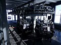
 Skidata turnstiles, Granges chairlift, Les Menuires.jpg 5,000 × 3,324; 6.71 MB
-
 Skipiste I79317.jpg 1,600 × 1,280; 832 KB
-
 Skipiste I79318.jpg 1,280 × 1,600; 960 KB
-
 Skipiste I79326.jpg 1,600 × 1,280; 6.5 MB
-
 Skipiste I79328.jpg 1,280 × 1,600; 6.69 MB
-
 Snowy mountains in Les Menuires, Saint-Martin-de-Belleville, France.jpg 4,848 × 3,120; 2.37 MB
-
 Station des Menuires.jpg 1,080 × 811; 508 KB
-
 Tapis roulant moving carpet funbelt ficap montagne les menuires.jpg 2,336 × 3,504; 11.82 MB
-
 Tarte aux myrtilles, L'Antigel, Les Menuires.jpg 5,176 × 3,442; 8.03 MB
-
 Terrasses au Front de neige des Menuires (janvier 2024).JPG 3,184 × 2,408; 3.02 MB
-
 Tour de France 2019 Val Thorens 12.jpg 3,840 × 2,160; 2.85 MB
-
 Télébenne de la Croisette aux Menuires en hiver (janvier 2024).JPG 3,264 × 2,448; 3.35 MB
-
 Vallon du Lou at dusk.jpg 6,016 × 4,000; 8.22 MB
-
 Vallon du Lou vu du col de la Chambre en hiver (2019).JPG 3,264 × 2,448; 4.16 MB
-
 View towards Val Thorens from Mont de la Chambre (35818772).jpg 2,505 × 1,944; 405 KB
-
 Village des Menuires depuis le front de neige (janvier 2024).JPG 3,264 × 2,448; 3.75 MB


.JPG)
.JPG)
.JPG)
.JPG)
_1.JPG)
_2.JPG)
_3.JPG)
.jpg)
.jpg)


.JPG)

_2.JPG)


.JPG)
.JPG)
.JPG)
.JPG)


.JPG)

.JPG)
.JPG)
.JPG)


.JPG)

.JPG)

.JPG)
.jpg)
.JPG)
.JPG)