Category:Leist
Jump to navigation
Jump to search
| Object location | | View all coordinates using: OpenStreetMap |
|---|
mountain in Switzerland  | |||||
| Upload media | |||||
| Instance of | |||||
|---|---|---|---|---|---|
| Location |
| ||||
| Elevation above sea level |
| ||||
 | |||||
Media in category "Leist"
The following 13 files are in this category, out of 13 total.
-
 Churfirsten001.JPG 3,088 × 2,320; 1.09 MB
-
 Churfirsten002.JPG 3,088 × 2,320; 958 KB
-
 Churfirsten003.JPG 3,088 × 2,320; 1.06 MB
-
 Churfirsten004.JPG 3,088 × 2,320; 1.03 MB
-
 Flumserberge-01.jpg 1,200 × 660; 177 KB
-
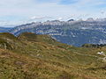
 Leist01.jpg 4,000 × 3,000; 5.78 MB
-
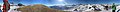 Panorama flumserberg-leist.jpg 13,614 × 1,315; 2.9 MB
-
 Tannenboden-Seebenalp Winter hiking trail - panoramio - Patrick Nouhailler's… (19).jpg 4,272 × 2,848; 2.61 MB
-
 Tannenboden-Seebenalp Winter hiking trail - panoramio - Patrick Nouhailler's… (22).jpg 4,272 × 2,848; 2.6 MB
-
 Tannenboden-Seebenalp Winter hiking trail - panoramio - Patrick Nouhailler's… (24).jpg 4,272 × 2,848; 2.93 MB
-
 Tannenboden-Seebenalp Winter hiking trail - panoramio - Patrick Nouhailler's… (57).jpg 4,272 × 2,848; 2.2 MB
-
 Tannenboden-Seebenalp Winter hiking trail - panoramio - Patrick Nouhailler's… (58).jpg 2,848 × 4,272; 2.19 MB
-
 Tannenboden-Seebenalp Winter hiking trail - panoramio - Patrick Nouhailler's… (70).jpg 4,272 × 2,848; 2.18 MB


.jpg)
.jpg)
.jpg)
.jpg)
.jpg)
.jpg)