Category:Lawley and Overdale
Jump to navigation
Jump to search
English: Lawley and Overdale is a civil parish in the Telford and Wrekin district, in the county of Shropshire, England.
civil parish in Telford and Wrekin, Shropshire, England | |||||
| Upload media | |||||
| Instance of | |||||
|---|---|---|---|---|---|
| Location | Telford and Wrekin, Shropshire, West Midlands, England | ||||
| Population |
| ||||
 | |||||
Subcategories
This category has the following 2 subcategories, out of 2 total.
Media in category "Lawley and Overdale"
The following 196 files are in this category, out of 196 total.
-
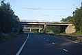
 A5223 Approaching Junction 6 M54 - geograph.org.uk - 4355600.jpg 640 × 467; 70 KB
-
 Acer Close, The Rock - geograph.org.uk - 6556223.jpg 1,795 × 1,346; 756 KB
-
 Another world up here - geograph.org.uk - 3919909.jpg 2,304 × 1,704; 1.03 MB
-
 Arleston Inn, Arleston, Telford - geograph.org.uk - 4911431.jpg 1,200 × 807; 355 KB
-
 Arleston Inn, Arleston, Telford - geograph.org.uk - 4911433.jpg 1,200 × 799; 588 KB
-
 Arleston Lane crosses the M54 - geograph.org.uk - 5411641.jpg 1,500 × 940; 130 KB
-
 Arlestone Lane Bridge, M54 - geograph.org.uk - 3101430.jpg 640 × 430; 50 KB
-
 ASDA, Telford - geograph.org.uk - 4551654.jpg 2,000 × 1,500; 1.03 MB
-
 Boyd House Computer Halls - geograph.org.uk - 5984276.jpg 1,000 × 461; 102 KB
-
 Boyd House Computer Halls Demolition - geograph.org.uk - 5984281.jpg 1,000 × 750; 167 KB
-
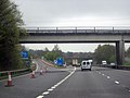
 Bridge over the M54 - geograph.org.uk - 3101487.jpg 640 × 430; 37 KB
-
 Bus Station, Telford - geograph.org.uk - 4551664.jpg 2,000 × 1,500; 1.14 MB
-
-
-
 Carpark at Telford Shopping Centre - geograph.org.uk - 4901090.jpg 1,200 × 799; 320 KB
-
 Church of Jesus Christ, Lawley - geograph.org.uk - 4896983.jpg 1,200 × 799; 314 KB
-
 Coach Central, Telford - geograph.org.uk - 3324257.jpg 1,280 × 856; 305 KB
-
 Community Hall - geograph.org.uk - 3399989.jpg 1,600 × 1,200; 323 KB
-
 Cone City, Lawley - geograph.org.uk - 1257405.jpg 640 × 480; 96 KB
-
 Cones on the A5223 - geograph.org.uk - 1257420.jpg 640 × 480; 62 KB
-
 Council Housing - The Meadows - geograph.org.uk - 3400788.jpg 1,600 × 1,200; 297 KB
-

-
 Crossing on Woodhouse Central - geograph.org.uk - 4551642.jpg 2,000 × 1,500; 1.38 MB
-
 Darby House, Telford - geograph.org.uk - 2299907.jpg 2,048 × 1,536; 1.47 MB
-
 Darby House, Telford - geograph.org.uk - 3228882.jpg 800 × 600; 254 KB
-

-

-

-
-

-
 Euston Park Business Park, Telford - geograph.org.uk - 4751854.jpg 800 × 469; 84 KB
-
 Euston Way - geograph.org.uk - 2302556.jpg 2,048 × 1,536; 1.77 MB
-
 Euston Way - geograph.org.uk - 3425994.jpg 800 × 600; 78 KB
-

-
 Flats at Lawley, Telford - geograph.org.uk - 4897007.jpg 1,200 × 799; 326 KB
-
 Footbridge across the M54 - geograph.org.uk - 6509614.jpg 1,548 × 2,064; 1.02 MB
-
 Footbridge at Telford Central Station - geograph.org.uk - 3324259.jpg 1,280 × 856; 253 KB
-
 Footbridge Over A442 Near Telford Station - geograph.org.uk - 5562636.jpg 3,264 × 2,448; 2.53 MB
-

-
 Footbridge over the A442 - geograph.org.uk - 4407382.jpg 640 × 426; 95 KB
-
 Footbridge, Junction 5, M54 - geograph.org.uk - 3101467.jpg 640 × 430; 38 KB
-

-
 Forge Junction on the M54 - geograph.org.uk - 5411656.jpg 1,500 × 920; 128 KB
-
-
 Garfield Road crosses the M54 - geograph.org.uk - 5411654.jpg 1,500 × 912; 123 KB
-
 Garfield Road overbridge - geograph.org.uk - 4378452.jpg 640 × 342; 103 KB
-
 Glendale Gardens - geograph.org.uk - 3402151.jpg 1,600 × 1,200; 317 KB
-
 Grays Hotel and Conference Centre - geograph.org.uk - 2302797.jpg 2,048 × 1,536; 1.61 MB
-
 Grays Hotel, Telford - geograph.org.uk - 3228780.jpg 640 × 480; 121 KB
-
 Heath Hill Tunnel.jpg 640 × 480; 94 KB
-
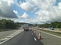
 HGV on the A442 - geograph.org.uk - 4407380.jpg 640 × 426; 68 KB
-
 Houses on Pepper Mill, Telford - geograph.org.uk - 4911440.jpg 1,200 × 799; 379 KB
-
 Houses on the Crescent, Lawley - geograph.org.uk - 4896986.jpg 1,200 × 799; 369 KB
-
 In Telford Civic Centre - geograph.org.uk - 5899041.jpg 640 × 480; 72 KB
-
 In Telford Civic Centre - geograph.org.uk - 5899079.jpg 640 × 480; 70 KB
-

-
 Ironmasters Way, Telford - geograph.org.uk - 2302814.jpg 2,048 × 1,536; 1.54 MB
-

-

-

-
 Lawley Village Day Nursery, Lawley - geograph.org.uk - 4897003.jpg 1,200 × 799; 292 KB
-
 Lawn Central, Telford - geograph.org.uk - 3321767.jpg 1,280 × 856; 266 KB
-
 Lawn Central, Telford - geograph.org.uk - 4551615.jpg 2,000 × 1,333; 1.21 MB
-
 Litter near Telford town centre - geograph.org.uk - 5899090.jpg 640 × 480; 126 KB
-
 Looking south along Old Park Way - geograph.org.uk - 6556221.jpg 1,402 × 1,052; 670 KB
-

-
 M54 approaches Dawley Road overbridge - geograph.org.uk - 3708809.jpg 3,648 × 2,736; 1.45 MB
-
 M54 approaches Garfield Road overbridge - geograph.org.uk - 3708779.jpg 3,554 × 2,589; 1.2 MB
-
 M54 approaches J5 interchange - geograph.org.uk - 3708558.jpg 3,534 × 2,608; 1.11 MB
-
 M54 approaches J6 interchange - geograph.org.uk - 3708789.jpg 3,530 × 2,616; 1.01 MB
-
 M54 approaches Mossy Greenway overbridge - geograph.org.uk - 3708600.jpg 3,648 × 2,736; 1.32 MB
-

-
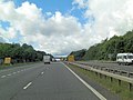
 M54 Eastbound Approaching Junction 5 - geograph.org.uk - 2907279.jpg 640 × 480; 61 KB
-

-

-
 M54 junction 6 ahead - geograph.org.uk - 4378454.jpg 640 × 325; 106 KB
-

-

-

-

-
-
-
 M54 Motorway - junction 5 overbridge - geograph.org.uk - 2246680.jpg 640 × 480; 47 KB
-

-
-

-
 M54 Motorway at junction 6 - geograph.org.uk - 2246716.jpg 640 × 480; 58 KB
-
-
 M54 westbound in Telford - geograph.org.uk - 3064547.jpg 640 × 480; 43 KB
-
 M54, eastbound - geograph.org.uk - 3101461.jpg 640 × 430; 36 KB
-
 M54, eastbound - geograph.org.uk - 3101481.jpg 640 × 430; 42 KB
-
 M54, Garfield Road Bridge - geograph.org.uk - 3101448.jpg 640 × 430; 34 KB
-
 M54, Junction 5 - geograph.org.uk - 3101472.jpg 640 × 430; 39 KB
-
 M54, Junction 6 - geograph.org.uk - 3101436.jpg 640 × 430; 47 KB
-
 M54, Junction 6 - geograph.org.uk - 3101438.jpg 640 × 430; 48 KB
-
 Martin Kaye office, Telford - geograph.org.uk - 4751851.jpg 800 × 614; 112 KB
-
 Mossygreen Way overbridge from M54 - geograph.org.uk - 4378449.jpg 640 × 396; 124 KB
-

-
 New Footbridge at Telford Central Station - geograph.org.uk - 5984291.jpg 1,000 × 841; 144 KB
-
 New pedestrian bridge, Telford Central Station - geograph.org.uk - 6189010.jpg 1,024 × 683; 186 KB
-
 Newdale Play Area - geograph.org.uk - 1929291.jpg 819 × 614; 211 KB
-
 Newdale Pool - geograph.org.uk - 1929293.jpg 819 × 614; 181 KB
-
 No coins^ No problem^ Telford - geograph.org.uk - 4780583.jpg 628 × 800; 170 KB
-

-
 Old Park Methodist Chapel - geograph.org.uk - 3763552.jpg 1,306 × 979; 462 KB
-
 Old Park Primitive Methodist - geograph.org.uk - 2482257.jpg 800 × 600; 140 KB
-

-
 OS benchmark - Dawley Bank, Ladygrove - geograph.org.uk - 4233163.jpg 734 × 979; 481 KB
-

-
 OS benchmark - Old Park Methodist Church - geograph.org.uk - 3763520.jpg 857 × 1,142; 560 KB
-
 OS benchmark - Old Park, former chapel - geograph.org.uk - 4186219.jpg 857 × 1,142; 554 KB
-
 OS benchmark - The Rock chapel wall - geograph.org.uk - 4233155.jpg 857 × 1,142; 553 KB
-

-
 OS benchmark - The Rock, Bellpit Rd - geograph.org.uk - 4186232.jpg 857 × 1,142; 469 KB
-

-
 OS cutmark - Telford, cycleway beside Queensway - geograph.org.uk - 3958253.jpg 857 × 1,142; 602 KB
-
 OS rivet - Lawley bank, subway wall - geograph.org.uk - 4235878.jpg 816 × 612; 340 KB
-
 OS rivet ^ benchmark - M54 overbridge - geograph.org.uk - 4186222.jpg 857 × 1,142; 592 KB
-

-

-
 OS rivet ^ cutmark, Hollinswood roundabout - geograph.org.uk - 3958246.jpg 857 × 1,142; 555 KB
-
 Park inn Telford - geograph.org.uk - 1863113.jpg 640 × 480; 65 KB
-
 Path to Telford Central - geograph.org.uk - 3322989.jpg 1,280 × 856; 479 KB
-

-
 Plaza 1 - Telford - geograph.org.uk - 3228916.jpg 600 × 800; 213 KB
-
 Plaza 1 and 2 - geograph.org.uk - 864338.jpg 640 × 480; 71 KB
-
 Plaza 1 Telford - geograph.org.uk - 3228862.jpg 600 × 800; 265 KB
-
 Plaza 1, Telford - geograph.org.uk - 4551630.jpg 1,500 × 2,250; 1.26 MB
-
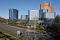
 Plaza at Telford - geograph.org.uk - 2302805.jpg 2,048 × 1,536; 1.41 MB
-
 Pond at Lawley - geograph.org.uk - 4896978.jpg 1,200 × 799; 375 KB
-
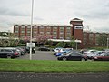
 Premier Inn Telford Central Hotel - geograph.org.uk - 4780596.jpg 800 × 455; 101 KB
-
 Premier Inn, Telford Central - geograph.org.uk - 2302562.jpg 2,048 × 1,536; 1.32 MB
-
 Public art in Telford Civic Centre - geograph.org.uk - 5899052.jpg 640 × 480; 90 KB
-
 Public art in Telford Civic Centre - geograph.org.uk - 5899069.jpg 640 × 480; 68 KB
-
 Railway tunnel under the Dawley to Wellington Road - geograph.org.uk - 6853512.jpg 1,714 × 2,285; 1.98 MB
-
 Rampart Way, Telfford - geograph.org.uk - 3228134.jpg 800 × 600; 235 KB
-
 Reflections of Telford - geograph.org.uk - 4551992.jpg 1,500 × 2,000; 1.09 MB
-
 Reflections of Telford - geograph.org.uk - 4552020.jpg 2,000 × 1,500; 1.45 MB
-

-
 Retail Park, Telford - geograph.org.uk - 2798747.jpg 1,024 × 682; 161 KB
-
 Sainsbury's supermarket, Telford Forge Retail Park - geograph.org.uk - 6607214.jpg 1,600 × 1,064; 198 KB
-

-
 Sculpture on roundabout at Telford Forge Retail Park - geograph.org.uk - 6607221.jpg 1,600 × 1,064; 358 KB
-
-
 Signpost in Telford - geograph.org.uk - 3321598.jpg 856 × 1,280; 319 KB
-
 Signpost in Telford - geograph.org.uk - 3322831.jpg 856 × 1,280; 417 KB
-
 Signpost in Telford - geograph.org.uk - 3322988.jpg 858 × 1,280; 281 KB
-
 Southwater car park - geograph.org.uk - 4552048.jpg 2,000 × 1,341; 1.02 MB
-
-
 Telford Bus Station - geograph.org.uk - 3324152.jpg 1,280 × 856; 225 KB
-
 Telford bus station - geograph.org.uk - 6305717.jpg 1,600 × 1,200; 421 KB
-
 Telford Central - geograph.org.uk - 3425978.jpg 800 × 600; 70 KB
-
 Telford Central railway station - geograph.org.uk - 4780376.jpg 800 × 629; 153 KB
-
 Telford Central Railway Station at night - geograph.org.uk - 5252030.jpg 3,264 × 1,840; 1.79 MB
-
 Telford Central railway station car park - geograph.org.uk - 4780558.jpg 800 × 471; 102 KB
-

-
 Telford Central station - geograph.org.uk - 4355565.jpg 1,600 × 1,064; 429 KB
-
 Telford Central Station - geograph.org.uk - 4407367.jpg 640 × 426; 97 KB
-
 Telford Central Station - geograph.org.uk - 4407370.jpg 640 × 570; 115 KB
-
 Telford Central Station - geograph.org.uk - 4407372.jpg 640 × 426; 64 KB
-
 Telford Central Station and car park - geograph.org.uk - 2302572.jpg 2,048 × 1,536; 1.47 MB
-
 Telford Civic Offices - geograph.org.uk - 1863135.jpg 640 × 480; 71 KB
-
 Telford Plaza (no 1) - geograph.org.uk - 1182878.jpg 480 × 640; 70 KB
-
 Telford Plaza (no 2) - geograph.org.uk - 1182862.jpg 640 × 480; 68 KB
-
 Telford Queensway - geograph.org.uk - 2303219.jpg 2,048 × 1,536; 1.44 MB
-
 Telford Station - geograph.org.uk - 3508290.jpg 800 × 600; 162 KB
-

-

-
 Telford Time - geograph.org.uk - 2036985.jpg 600 × 800; 106 KB
-
 Telford, town centre Christmas tree - geograph.org.uk - 2204677.jpg 640 × 480; 38 KB
-
 The 'Forge Bug Motel' - geograph.org.uk - 6610510.jpg 1,393 × 1,858; 1.66 MB
-

-
 The A5 crosses the M54 - geograph.org.uk - 5411657.jpg 1,500 × 999; 149 KB
-
 The A5223 crosses the M54 - geograph.org.uk - 5411651.jpg 1,500 × 981; 135 KB
-
 The Grazing Cow, Lawley - geograph.org.uk - 4896996.jpg 1,200 × 799; 249 KB
-
 The Grazing Cow, Lawley - geograph.org.uk - 4896998.jpg 1,200 × 799; 317 KB
-
 The Grazing Cow, Lawley - geograph.org.uk - 4897000.jpg 771 × 1,200; 221 KB
-

-
 The new Asda store is coming - geograph.org.uk - 3763559.jpg 1,142 × 857; 377 KB
-
 The new Telford Central Footbridge - geograph.org.uk - 6232530.jpg 1,858 × 1,393; 815 KB
-
 The Newdale tramway bridge - geograph.org.uk - 6828491.jpg 2,448 × 1,836; 2.19 MB
-
 The Plaza at Telford - geograph.org.uk - 2299894.jpg 2,048 × 1,536; 1.58 MB
-
 The Ramparts, Rampart Way - geograph.org.uk - 864365.jpg 640 × 480; 131 KB
-
 The Telford Shopping Centre - geograph.org.uk - 2302822.jpg 2,048 × 1,536; 1.65 MB
-

-

-
-
 Village Drive - geograph.org.uk - 3400809.jpg 1,600 × 1,200; 323 KB
-
 Village Green - geograph.org.uk - 3399998.jpg 3,488 × 2,616; 2.1 MB
-
 Village Green - geograph.org.uk - 3400817.jpg 1,600 × 1,200; 502 KB
-

-

-

-
 Wrekin Way junction - geograph.org.uk - 1257414.jpg 640 × 480; 82 KB
-
 WWI memorial - Old Park Methodist Church - geograph.org.uk - 3763539.jpg 1,102 × 1,469; 390 KB
-
 Filling up - so you can - geograph.org.uk - 636228.jpg 640 × 480; 49 KB


_-_geograph.org.uk_-_3763508.jpg)


_-_geograph.org.uk_-_1182878.jpg)
_-_geograph.org.uk_-_1182862.jpg)


