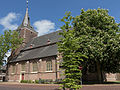
Category:Laurentiuskerk, Varsseveld
Jump to navigation
Jump to search
| Object location | | View all coordinates using: OpenStreetMap |
|---|
church building in Oude IJsselstreek, Netherlands  | |||||
| Upload media | |||||
| Instance of | |||||
|---|---|---|---|---|---|
| Location | Varsseveld, Oude IJsselstreek, Gelderland, Netherlands | ||||
| Street address |
| ||||
| Located on street |
| ||||
| Heritage designation |
| ||||
 | |||||
Nederlands: Grote - of Laurentiuskerk, Varsseveld - anno 15e eeuw
|
This is a category about rijksmonument number 39093
|
| Address |
|
Media in category "Laurentiuskerk, Varsseveld"
The following 44 files are in this category, out of 44 total.
-
 2014-03 d66 varsseveld 01.JPG 3,258 × 4,344; 1.62 MB
-
 2024-08-07 Laurentiuskerk Varsseveld 01.jpg 6,240 × 3,512; 11.35 MB
-
 2024-08-07 Laurentiuskerk Varsseveld 02.jpg 6,240 × 3,512; 11.33 MB
-
 2024-08-07 Laurentiuskerk Varsseveld 03.jpg 6,240 × 3,512; 11.31 MB
-
 2024-08-07 Laurentiuskerk Varsseveld 04.jpg 6,240 × 3,512; 11.32 MB
-
 2024-08-07 Laurentiuskerk Varsseveld 05.jpg 6,240 × 3,512; 12.57 MB
-
 2024-08-07 Laurentiuskerk Varsseveld 06.jpg 6,240 × 3,512; 11.8 MB
-
 2024-08-07 Laurentiuskerk Varsseveld 07.jpg 3,512 × 6,240; 11.83 MB
-
 2024-08-07 Laurentiuskerk Varsseveld 08.jpg 3,512 × 6,240; 12.52 MB
-
 2024-08-07 Laurentiuskerk Varsseveld 09.jpg 6,240 × 3,512; 13 MB
-
 2024-08-07 Laurentiuskerk Varsseveld 10.jpg 6,240 × 3,512; 12.35 MB
-
 2024-08-07 Laurentiuskerk Varsseveld 11.jpg 3,512 × 6,240; 12.23 MB
-
 2024-08-07 Laurentiuskerk Varsseveld 12.jpg 6,240 × 3,512; 14.13 MB
-
 2024-08-07 Laurentiuskerk Varsseveld 13.jpg 6,240 × 3,512; 11.58 MB
-
 2024-08-07 Laurentiuskerk Varsseveld 14.jpg 3,512 × 6,240; 11.98 MB
-
 Albert Boeken Hervormde Kerk Varsseveld restauratie.jpg 6,906 × 6,368; 2.18 MB
-
 Exterieur - Varsseveld - 20238650 - RCE.jpg 952 × 1,200; 235 KB
-
 Exterieur - Varsseveld - 20238651 - RCE.jpg 1,200 × 943; 281 KB
-
 Interieur, aanzicht orgel, orgelnummer 1540 - Varsseveld - 20370226 - RCE.jpg 816 × 1,200; 159 KB
-
 INTERIEUR, SCHIP, NOORDWEST HOEK - Varsseveld - 20265549 - RCE.jpg 771 × 1,200; 208 KB
-
 INTERIEUR, SCHIP, NOORDWEST HOEK - Varsseveld - 20265551 - RCE.jpg 769 × 1,200; 213 KB
-
 INTERIEUR, SCHIP, NOORDWEST HOEK - Varsseveld - 20265552 - RCE.jpg 771 × 1,200; 192 KB
-
 INTERIEUR, TOREN, NOORDOOST HOEK - Varsseveld - 20265545 - RCE.jpg 789 × 1,200; 162 KB
-
 INTERIEUR, TOREN, NOORDOOST HOEK - Varsseveld - 20265550 - RCE.jpg 766 × 1,200; 237 KB
-
 INTERIEUR, TRAP IN OOSTMUUR - Varsseveld - 20265544 - RCE.jpg 796 × 1,200; 157 KB
-
 Noorderzijbeuk gezien naar het oosten - Varsseveld - 20238663 - RCE.jpg 801 × 1,200; 216 KB
-
 Noordoosthoek van de zuidelijke zijbeuk - Varsseveld - 20238654 - RCE.jpg 808 × 1,200; 249 KB
-
 Noordwand van het koor - Varsseveld - 20238655 - RCE.jpg 804 × 1,200; 235 KB
-
 Opgraving - Varsseveld - 20238662 - RCE.jpg 800 × 1,200; 202 KB
-
 Opgravingen - Varsseveld - 20238659 - RCE.jpg 789 × 1,200; 241 KB
-
 Opgravingen - Varsseveld - 20238660 - RCE.jpg 785 × 1,200; 236 KB
-
 Opgravingen - Varsseveld - 20238661 - RCE.jpg 793 × 1,200; 187 KB
-
-
 Opgravingsplattegrond - Varsseveld - 20238657 - RCE.jpg 1,200 × 807; 205 KB
-
 Pentekening M. de Raat - Varsseveld - 20238652 - RCE.jpg 1,200 × 877; 160 KB
-
 Portalen - Varsseveld - 20238648 - RCE.jpg 1,192 × 1,200; 332 KB
-
 Portalen - Varsseveld - 20238649 - RCE.jpg 1,193 × 1,200; 361 KB
-
 Protestant church of Varsseveld - panoramio.jpg 4,288 × 2,848; 3.91 MB
-
 Schip gezien naar het westen - Varsseveld - 20238664 - RCE.jpg 809 × 1,200; 217 KB
-
 Varsseveld Laurentiuskerk.jpg 2,048 × 1,536; 1.36 MB
-
 Varsseveld, de Grote of Laurentiuskerk RM39093 foto5 2015-05-14 11.59.jpg 4,107 × 3,083; 10.92 MB
-
 Varsseveld, de Grote of Laurentiuskerk RM39093 IMG 5427 2020-05-09 13.58.jpg 3,382 × 5,073; 11.24 MB
-
 Westwand van het schip onder orgel - Varsseveld - 20238656 - RCE.jpg 1,200 × 804; 167 KB
-


