Category:Langstone Harbour
Jump to navigation
Jump to search

harbour in Hampshire, England, UK  | |||||
| Upload media | |||||
| Instance of | |||||
|---|---|---|---|---|---|
| Location | Langstone, Havant, Hampshire, South East England, England | ||||
 | |||||
Subcategories
This category has the following 14 subcategories, out of 14 total.
B
- Bedhampton Wharf, Hampshire (4 F)
F
H
- Hayling Ferry (36 F)
L
- Langstone Bridge (14 F)
M
- Milton Lock, Portsmouth (16 F)
N
- North Binness Island (12 F)
P
- Portsmouth Lifeboat Station (9 F)
S
- Southmoor Nature Reserve (2 F)
- Southsea Marina (8 F)
T
- The Kench (20 F)
W
- West Hayling (3 F)
Media in category "Langstone Harbour"
The following 182 files are in this category, out of 182 total.
-
 A very special place - geograph.org.uk - 709716.jpg 640 × 480; 55 KB
-
 A3(M) from Portsdown Hill Road bridge in Bedhampton.jpg 4,128 × 3,096; 4.02 MB
-
 Across Chichester Harbour - geograph.org.uk - 3509117.jpg 4,000 × 2,666; 7.43 MB
-
-
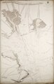
 Admiralty Chart No 3418 Langston Harbour, Published 1943.jpg 8,815 × 13,201; 30.88 MB
-
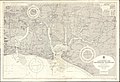 Admiralty Chart No 3418 Langstone and Chichester Harbours, Published 1968.jpg 16,392 × 11,247; 91.53 MB
-
 Almost a lagoon - geograph.org.uk - 1507492.jpg 640 × 360; 38 KB
-
 Angling at Langstone Harbour.jpg 4,000 × 3,000; 3.63 MB
-
 Arrowheads and Blade.jpg 4,608 × 3,456; 4.03 MB
-
 Baker's island From the top of portsdown.JPG 858 × 50; 29 KB
-
 Bakers Island, Langstone Harbour. - geograph.org.uk - 24742.jpg 640 × 426; 104 KB
-
 Beautiful river at Langstone - geograph.org.uk - 687939.jpg 640 × 480; 35 KB
-
 Birds scatter at North Hayling - geograph.org.uk - 709706.jpg 640 × 480; 38 KB
-
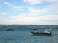
 Boats anchored at Langstone Harbour.jpg 4,000 × 3,000; 6.11 MB
-
 Boats in Langstone Harbour - geograph.org.uk - 1193785.jpg 640 × 443; 49 KB
-
 Boats in Langstone Harbour - geograph.org.uk - 3389621.jpg 1,024 × 768; 381 KB
-
 Brent geese in Langstone Harbour - geograph.org.uk - 1533420.jpg 640 × 360; 52 KB
-
 Broadmarsh Coastal Park slipway with Bedhampton Wharf to rear (P1040173).jpg 4,896 × 3,672; 8.91 MB
-
 Brockhampton - geograph.org.uk - 5119.jpg 640 × 427; 179 KB
-
 Brockhampton - geograph.org.uk - 5121.jpg 640 × 427; 198 KB
-
 Budds Farm Wastewater Treatment Works 2.jpg 4,000 × 3,000; 5.1 MB
-
 Budds Farm Wastewater Treatment Works 3.jpg 4,000 × 3,000; 5.22 MB
-

-

-

-

-
 Chichester, Langstone & Portsmouth Harbours.svg 377 × 211; 1.99 MB
-
 Coastal Path, Langstone Harbour - geograph.org.uk - 3528957.jpg 4,000 × 2,666; 6.88 MB
-
 Coastal Path, Langstone Harbour - geograph.org.uk - 3528963.jpg 3,959 × 2,639; 7.63 MB
-

-
 Derelict boat off Hayling Island - geograph.org.uk - 1507490.jpg 640 × 360; 37 KB
-

-
 Dredger in Langstone Harbour - geograph.org.uk - 623835.jpg 640 × 480; 53 KB
-
 English Channel (42384592704).jpg 3,434 × 2,175; 1.1 MB
-
 Entering Langstone Harbour - geograph.org.uk - 1245638.jpg 640 × 480; 40 KB
-
 Entering Langstone Harbour - geograph.org.uk - 1245642.jpg 640 × 480; 45 KB
-
 Entrance Channel, Langstone Harbour - geograph.org.uk - 1245617.jpg 640 × 480; 44 KB
-

-
 Entrance to Langstone Harbour, Hampshire, England.jpg 2,562 × 1,904; 2.06 MB
-
 Farlington and North Langstone Harbour.jpg 4,000 × 2,250; 8.65 MB
-
 Farlington Marshes from A27.jpg 3,918 × 2,204; 6.57 MB
-
 Field by Langstone Harbour - geograph.org.uk - 1227438.jpg 640 × 427; 143 KB
-
 Foreshore at Hayling Island, Langstone Harbour - geograph.org.uk - 1726293.jpg 3,872 × 2,592; 4.65 MB
-
 Fort Cumberland by Langstone Harbour Entrance.jpg 4,000 × 3,000; 5.7 MB
-
 Hayling coast near Stoke - geograph.org.uk - 1292448.jpg 640 × 471; 43 KB
-
 Hayling Island - The Three Harbours.svg 377 × 211; 1.99 MB
-
 Hayling Island, Langstone Harbour - geograph.org.uk - 148278.jpg 640 × 480; 117 KB
-

-
 I am not worthy - geograph.org.uk - 685987.jpg 640 × 480; 40 KB
-
-
 Langstone Channel - geograph.org.uk - 1193771.jpg 640 × 480; 50 KB
-
 Langstone foreshore at low tide - geograph.org.uk - 337690.jpg 597 × 640; 159 KB
-
 Langstone Harbour - Flickr - Stewart Black.jpg 4,432 × 2,945; 9.93 MB
-
 Langstone Harbour - geograph.org.uk - 1077639.jpg 640 × 480; 309 KB
-
 Langstone Harbour - geograph.org.uk - 2891228.jpg 1,600 × 1,067; 383 KB
-
 Langstone Harbour - geograph.org.uk - 371023.jpg 640 × 480; 50 KB
-
 Langstone Harbour - geograph.org.uk - 371081.jpg 640 × 506; 86 KB
-
 Langstone Harbour - geograph.org.uk - 6507620.jpg 1,024 × 681; 46 KB
-
 Langstone Harbour - geograph.org.uk - 6507691.jpg 1,024 × 681; 81 KB
-
 Langstone Harbour - geograph.org.uk - 6507719.jpg 1,024 × 681; 100 KB
-
 Langstone Harbour - geograph.org.uk - 6507720.jpg 1,024 × 681; 57 KB
-
 Langstone Harbour - geograph.org.uk - 6507721.jpg 1,024 × 681; 69 KB
-
 Langstone Harbour - geograph.org.uk - 6507723.jpg 1,024 × 681; 44 KB
-
 Langstone Harbour - geograph.org.uk - 6507727.jpg 1,024 × 681; 95 KB
-
 Langstone Harbour -1 (5208313501).jpg 800 × 533; 345 KB
-
 Langstone Harbour at mid tide - geograph.org.uk - 1222580.jpg 640 × 427; 128 KB
-
 Langstone Harbour at mid tide - geograph.org.uk - 1222608.jpg 640 × 421; 139 KB
-
 Langstone harbour bridgeside view 2011.JPG 2,894 × 1,886; 2.1 MB
-
 Langstone Harbour Entrance - geograph.org.uk - 1245637.jpg 640 × 480; 32 KB
-
 Langstone Harbour Fishermans Association - geograph.org.uk - 6450916.jpg 1,024 × 681; 230 KB
-
 Langstone Harbour Information Board - geograph.org.uk - 1507462.jpg 640 × 360; 52 KB
-
 Langstone Harbour Phoenix breakwater 2013.JPG 5,112 × 3,096; 4.21 MB
-
 Langstone Harbour Phoenix breakwater.JPG 876 × 458; 187 KB
-

-
 Langstone Harbour, Hampshire - geograph.org.uk - 1729182.jpg 3,872 × 2,592; 3.01 MB
-
 Langstone Harbour, Hampshire - geograph.org.uk - 1729194.jpg 3,872 × 2,592; 3.35 MB
-
 Langstone Harbour, Hampshire - geograph.org.uk - 1729210.jpg 3,872 × 2,592; 2.64 MB
-
 Langstone Harbour, Hants. - geograph.org.uk - 1508939.jpg 640 × 420; 95 KB
-
 Langstone Harbour, high tide - geograph.org.uk - 525391.jpg 640 × 480; 76 KB
-
 Langstone Harbour.jpg 4,000 × 3,000; 5.88 MB
-
 Langstone P1010037.JPG 3,072 × 2,304; 2.92 MB
-
 Langstone Sailing Club, Hampshire - geograph.org.uk - 1720045.jpg 3,872 × 2,592; 4.64 MB
-
 Langstone Sailing Club, Hampshire - geograph.org.uk - 1720055.jpg 3,872 × 2,592; 3.49 MB
-
 Langstone salt water lagoon.JPG 4,000 × 3,000; 6.16 MB
-

-
 Light on water in Langstone Harbour - geograph.org.uk - 1507483.jpg 640 × 360; 32 KB
-
 Little Egret (7997638482).jpg 2,886 × 1,924; 1.19 MB
-
 Long Island - geograph.org.uk - 351276.jpg 640 × 480; 27 KB
-
 Look what I've got! (8038776022).jpg 2,580 × 1,787; 1.36 MB
-

-
 Looking Across Langstone Harbour, Hampshire - geograph.org.uk - 1724606.jpg 3,872 × 2,592; 3.58 MB
-
 Looking Across Langstone Harbour, Hampshire - geograph.org.uk - 1724619.jpg 3,872 × 2,592; 4.54 MB
-

-

-

-

-

-
 Low tide on Langstone foreshore - geograph.org.uk - 1223672.jpg 640 × 428; 128 KB
-
 Low tide on Langstone foreshore - geograph.org.uk - 1227469.jpg 640 × 418; 146 KB
-
 Low tide on Langstone foreshore - geograph.org.uk - 1228257.jpg 640 × 415; 208 KB
-
 Marshes, Langstone Harbour - geograph.org.uk - 6502399.jpg 1,024 × 681; 126 KB
-

-
 Much work to do - geograph.org.uk - 683995.jpg 640 × 480; 52 KB
-
 Mud, Langstone Harbour - geograph.org.uk - 3771322.jpg 640 × 480; 119 KB
-
 Muddy but magical - geograph.org.uk - 1507494.jpg 640 × 360; 48 KB
-
 Neolithic Adze (l). Backed Knife, probably Palaeolitic (r).jpg 4,608 × 3,456; 4.09 MB
-
 No access to the island - geograph.org.uk - 6507571.jpg 1,024 × 681; 122 KB
-
 Pebble bank on Langstone foreshore - geograph.org.uk - 1228216.jpg 640 × 411; 206 KB
-

-
 Portsdown Hill, Hampshire 02.jpg 4,128 × 3,096; 5.3 MB
-
 Portsdown Hill, Hampshire 04.jpg 4,128 × 3,096; 4.56 MB
-
 Portsdown Hill, Hampshire 06.jpg 4,128 × 3,096; 5.67 MB
-
 Portsdown Hill, Hampshire 07.jpg 4,128 × 3,096; 4.62 MB
-
 Portsdown Hill, Hampshire 08.jpg 4,128 × 3,096; 4.4 MB
-
 Portsdown Hill, Hampshire 10.jpg 4,128 × 3,096; 5.24 MB
-
 Portsea Island - The Three Harbours.svg 377 × 211; 1.99 MB
-

-

-

-
 Sea wall, Langstone Harbour - geograph.org.uk - 2776138.jpg 1,600 × 1,200; 723 KB
-
 SelseyHaylingPortsea.JPG 3,168 × 4,224; 3.91 MB
-
 Sheer Magic in Broom Channel, Langstone Harbour.jpg 4,000 × 3,000; 5.12 MB
-

-
 Slipway at Langstone Harbour, Hampshire - geograph.org.uk - 3510147.jpg 4,000 × 2,671; 6.63 MB
-
-

-

-
 Southmoor across Langstone Harbour - geograph.org.uk - 1481270.jpg 640 × 146; 19 KB
-
 Southsea Marina.jpg 4,000 × 2,250; 1.93 MB
-
 Spiral Twisted Copper-alloy Torc - 53631651156.jpg 4,608 × 3,456; 3.71 MB
-
 Spit of land in Langstone Harbour - geograph.org.uk - 1507485.jpg 640 × 360; 44 KB
-

-

-
 Stone Carving - 53631858893.jpg 3,163 × 2,372; 4.44 MB
-

-

-
 The A3(M) M27 interchange, Farlington.jpg 626 × 442; 204 KB
-
 The entrance to Langstone Harbour - geograph.org.uk - 1272065.jpg 640 × 412; 74 KB
-

-

-

-
 The Royal Oak - panoramio (cropped).jpg 756 × 756; 349 KB
-
 The Royal Oak - panoramio.jpg 768 × 1,024; 549 KB
-
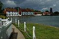
 The Royal Oak and Langstone Mill - geograph.org.uk - 362.jpg 640 × 480; 75 KB
-
 The Royal Oak at Langstone Quay - geograph.org.uk - 1506495.jpg 640 × 360; 55 KB
-

-
 The Royal Oak, Langstone at High Tide. - geograph.org.uk - 117784.jpg 640 × 437; 114 KB
-
 The Royal Oak, Langstone, Hampshire - geograph.org.uk - 1717721.jpg 2,032 × 1,360; 1.75 MB
-
 The Royal Oak, Langstone, Hampshire - geograph.org.uk - 1717736.jpg 3,872 × 2,592; 3.73 MB
-
 The Royal Oak, Langstone, Hampshire - geograph.org.uk - 1721076.jpg 3,872 × 2,176; 3.43 MB
-
 The Ship Inn, Langstone Harbour. - geograph.org.uk - 176533.jpg 640 × 436; 88 KB
-
 The Solent Way (294) - geograph.org.uk - 3137679.jpg 800 × 600; 58 KB
-
 The Solent Way (303) - geograph.org.uk - 3137800.jpg 800 × 600; 120 KB
-
 The Solent Way (304) - geograph.org.uk - 3137806.jpg 800 × 600; 93 KB
-
 The Solent Way (306) - geograph.org.uk - 3137825.jpg 800 × 600; 138 KB
-
 The Solent Way (308) - geograph.org.uk - 3137856.jpg 800 × 600; 109 KB
-
 The Solent Way (309) - geograph.org.uk - 3138126.jpg 800 × 600; 134 KB
-
 The Tide's in at Langstone. - geograph.org.uk - 176540.jpg 640 × 439; 99 KB
-

-

-
 View Across Langstone Harbour, Hampshire - geograph.org.uk - 1720079.jpg 3,864 × 1,687; 1.11 MB
-
 View across Langstone Harbour, Langstone (May 2019) (1).JPG 2,800 × 1,800; 1.93 MB
-
 View across Langstone Harbour, Langstone (May 2019) (2).JPG 3,000 × 2,000; 2.2 MB
-
 View across Langstone Harbour, Langstone (May 2019) (3).JPG 3,000 × 2,000; 2.08 MB
-
 View across Langstone Harbour, Langstone (May 2019) (4).JPG 3,000 × 2,000; 2.15 MB
-
 View of Langstone Harbour.jpg 4,032 × 3,024; 3.39 MB
-
 View out over Langstone Harbour - geograph.org.uk - 683723.jpg 640 × 480; 26 KB
-
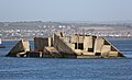
 W W 2 Mulberry Harbour section lies broken-backed in Langstone Harbour. - panoramio.jpg 3,264 × 2,448; 2.11 MB
-

-
 Watching Langstone Harbour - geograph.org.uk - 370251.jpg 640 × 480; 94 KB
-
 West Area of Langstone Harbour.jpg 4,000 × 3,000; 6.26 MB
-
 Wigeon in Langstone Harbour off the Solent Way at Broadmarsh Coastal Park (P1040162).jpg 4,896 × 3,672; 9.67 MB
-
 Winter migrants in Langstone Harbour - geograph.org.uk - 1533401.jpg 640 × 360; 65 KB
-
 Wreck near Gunners Point - geograph.org.uk - 1245646.jpg 480 × 640; 71 KB
-
 Yachts in Langstone Harbour - geograph.org.uk - 1423391.jpg 640 × 471; 34 KB
-
 Between Hayling Island and Portsea - geograph.org.uk - 502275.jpg 640 × 480; 87 KB
-
 Langstone Harbour - geograph.org.uk - 226068.jpg 640 × 479; 94 KB
-
 Langstone Harbour - geograph.org.uk - 363491.jpg 640 × 480; 88 KB
-
 MulberryCaisson, Langstone Harbour - geograph.org.uk - 54590.jpg 640 × 480; 45 KB
-
 Outflow into Langstone Harbour - geograph.org.uk - 370305.jpg 640 × 480; 87 KB
-
 Sarsens, Langstone Harbour, Hampshire - geograph.org.uk - 54576.jpg 640 × 480; 97 KB
-
 Storm clouds over Langstone Harbour - geograph.org.uk - 378642.jpg 640 × 427; 111 KB

_from_Portsdown_Hill_Road_bridge_in_Bedhampton.jpg)


.jpg)


.jpg)


.jpg)


.jpg)

.jpg)


._Backed_Knife,_probably_Palaeolitic_(r).jpg)


.jpg)
.jpg)
_M27_interchange,_Farlington.jpg)


.jpg)


_-_geograph.org.uk_-_3137679.jpg)
_-_geograph.org.uk_-_3137800.jpg)
_-_geograph.org.uk_-_3137806.jpg)
_-_geograph.org.uk_-_3137825.jpg)
_-_geograph.org.uk_-_3137856.jpg)
_-_geograph.org.uk_-_3138126.jpg)


_(1).JPG)
_(2).JPG)
_(3).JPG)
_(4).JPG)


.jpg)


