Category:Lange Voorhout 14, The Hague
Jump to navigation
Jump to search
| Object location | | View all coordinates using: OpenStreetMap |
|---|
building in The Hague, Netherlands  | |||||
| Upload media | |||||
| Instance of | |||||
|---|---|---|---|---|---|
| Location | The Hague, South Holland, Netherlands | ||||
| Located on street |
| ||||
| Heritage designation |
| ||||
 | |||||
|
This is a category about rijksmonument number 17696
|
| Address |
|
Media in category "Lange Voorhout 14, The Hague"
The following 9 files are in this category, out of 9 total.
-
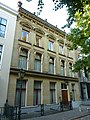 Den Haag - Lange Voorhout 14.JPG 2,736 × 3,648; 4.75 MB
-
 Exterieur OVERZICHT SMEEDIJZEREN STOEPHEK - 's-Gravenhage - 20272592 - RCE.jpg 1,197 × 1,200; 366 KB
-
 Exterieur OVERZICHT SMEEDIJZEREN STOEPHEK - 's-Gravenhage - 20272593 - RCE.jpg 1,195 × 1,200; 332 KB
-
 Exterieur SMEEDIJZEREN RAAMHEK - 's-Gravenhage - 20272591 - RCE.jpg 1,193 × 1,200; 278 KB
-
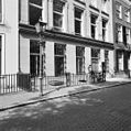
 Ingang - 's-Gravenhage - 20091066 - RCE.jpg 850 × 1,200; 203 KB
-
 Plafond - 's-Gravenhage - 20091067 - RCE.jpg 1,200 × 887; 205 KB
-
 Plafond - 's-Gravenhage - 20091068 - RCE.jpg 1,200 × 722; 204 KB
-
 Voorhout, Den Haag, Netherlands - panoramio (51).jpg 4,896 × 3,264; 6.47 MB
-
 Voorhout, Den Haag, Netherlands - panoramio (63).jpg 4,896 × 3,264; 6.86 MB


.jpg)
.jpg)