Category:Lange Nieuwstraat 30, Hulst
Jump to navigation
Jump to search
| Object location | | View all coordinates using: OpenStreetMap |
|---|
building in Hulst, Netherlands  | |||||
| Upload media | |||||
| Instance of | |||||
|---|---|---|---|---|---|
| Location | Hulst, Zeeland, Netherlands | ||||
| Street address |
| ||||
| Heritage designation | |||||
 | |||||
|
This is a category about rijksmonument number 22763
|
| Address |
|
Media in category "Lange Nieuwstraat 30, Hulst"
The following 17 files are in this category, out of 17 total.
-
 Exterieur ACHTERGEVEL - Hulst - 20316701 - RCE.jpg 1,193 × 1,200; 399 KB
-
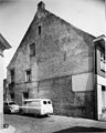
 Exterieur LINKER ZIJGEVEL - Hulst - 20293793 - RCE.jpg 1,200 × 788; 266 KB
-
 Exterieur LINKER ZIJGEVEL - Hulst - 20316699 - RCE.jpg 1,190 × 1,200; 332 KB
-
 Exterieur LINKER ZIJGEVEL ENACHTERGEVEL - Hulst - 20316700 - RCE.jpg 1,192 × 1,200; 341 KB
-
 Exterieur OVERZICHT - Hulst - 20293790 - RCE.jpg 1,200 × 788; 235 KB
-
 Exterieur OVERZICHT - Hulst - 20293795 - RCE.jpg 788 × 1,200; 208 KB
-
 Exterieur OVERZICHT LINKER ZIJGEVEL - Hulst - 20293792 - RCE.jpg 788 × 1,200; 259 KB
-
 Exterieur SCHEUR IN ZIJGEVEL - Hulst - 20293794 - RCE.jpg 775 × 1,200; 229 KB
-
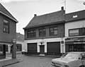
 Exterieur VOORGEVEL - Hulst - 20293791 - RCE.jpg 788 × 1,200; 203 KB
-
 Exterieur VOORGEVEL - Hulst - 20316698 - RCE.jpg 1,192 × 1,200; 360 KB
-
 Hoek Zomerstr. - Hulst - 20118867 - RCE.jpg 957 × 1,200; 299 KB
-
 Hulst - rijksmonument 22763 - Lange Nieuwstraat 30 20120714.jpg 594 × 800; 186 KB
-
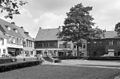
 Overzicht - Hulst - 20118870 - RCE.jpg 1,200 × 940; 336 KB
-
 Overzicht - Hulst - 20118871 - RCE.jpg 946 × 1,200; 215 KB
-
 Voorgevel - Hulst - 20118869 - RCE.jpg 1,200 × 814; 240 KB
-
 Voorgevel - Hulst - 20118872 - RCE.jpg 1,200 × 951; 206 KB
-
 Zijgevel - Hulst - 20118873 - RCE.jpg 948 × 1,200; 229 KB


