Category:Lange Houtstraat 11, The Hague
Jump to navigation
Jump to search
| Object location | | View all coordinates using: OpenStreetMap |
|---|
building in The Hague, Netherlands  | |||||
| Upload media | |||||
| Instance of | |||||
|---|---|---|---|---|---|
| Location | The Hague, South Holland, Netherlands | ||||
| Street address |
| ||||
| Located on street | |||||
| Heritage designation |
| ||||
 | |||||
|
This is a category about rijksmonument number 17669
|
| Address |
|
Media in category "Lange Houtstraat 11, The Hague"
The following 17 files are in this category, out of 17 total.
-
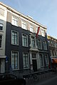 Den Haag - Lange Houtstraat 11.JPG 3,056 × 4,592; 4.08 MB
-
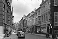 Overzicht - 's-Gravenhage - 20088646 - RCE.jpg 1,200 × 805; 165 KB
-
 Overzicht - 's-Gravenhage - 20088647 - RCE.jpg 1,200 × 803; 165 KB
-
 Plafonds - 's-Gravenhage - 20088655 - RCE.jpg 1,200 × 904; 216 KB
-
 Plafonds - 's-Gravenhage - 20088656 - RCE.jpg 1,200 × 923; 150 KB
-
 Plafonds - 's-Gravenhage - 20088657 - RCE.jpg 1,200 × 867; 117 KB
-
 Plafonds - 's-Gravenhage - 20088658 - RCE.jpg 1,200 × 866; 132 KB
-
 Plafonds - 's-Gravenhage - 20088659 - RCE.jpg 1,200 × 860; 158 KB
-
 Plafonds - 's-Gravenhage - 20088660 - RCE.jpg 1,200 × 856; 187 KB
-
 Plafonds - 's-Gravenhage - 20088661 - RCE.jpg 1,200 × 873; 157 KB
-
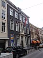 Rm17669.JPG 2,736 × 3,648; 1.99 MB
-
 Schoorsteen - 's-Gravenhage - 20088662 - RCE.jpg 867 × 1,200; 188 KB
-
 Schoorsteen - 's-Gravenhage - 20088663 - RCE.jpg 866 × 1,200; 217 KB
-
 Schoorsteen - 's-Gravenhage - 20088664 - RCE.jpg 860 × 1,200; 185 KB
-
 Schoorsteen - 's-Gravenhage - 20088665 - RCE.jpg 1,200 × 885; 190 KB
-
 Schoorsteen - 's-Gravenhage - 20088666 - RCE.jpg 1,200 × 901; 197 KB
-
 Schoorsteen - 's-Gravenhage - 20088667 - RCE.jpg 861 × 1,200; 175 KB


