Category:Lanfonnet
Jump to navigation
Jump to search
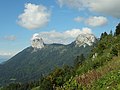
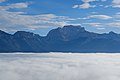
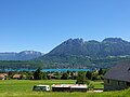
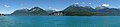
summit in France .jpg) Vue du Lanfonnet depuis Duingt à l'ouest. | |||||
| Upload media | |||||
| Instance of |
| ||||
|---|---|---|---|---|---|
| Location |
| ||||
| Mountain range | |||||
| Elevation above sea level |
| ||||
 | |||||
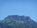
Lanfonnet ou Frettes du Lanfonnet ou Roche Murraz
Media in category "Lanfonnet"
The following 140 files are in this category, out of 140 total.
-
 Annecy, Alpes, Francia, 2015 05.JPG 4,000 × 3,000; 4.57 MB
-
 Annecy, nieve en las montañas, Francia, 2015 06.JPG 4,000 × 3,000; 4.63 MB
-
 Belvédère @ Semnoz (50971078557).jpg 6,240 × 4,160; 4.5 MB
-
 Belvédère de Bénévent @ Semnoz (50972369911).jpg 5,472 × 3,648; 5.7 MB
-
 Bluffy, Talloires-Dents de Lanfon et Roche Murraz et parapentes.jpg 4,608 × 3,456; 4.11 MB
-
 Bluffy, Talloires-Dents de Lanfon et Roche Murraz, manche.jpg 4,608 × 3,456; 4.9 MB
-
 Bluffy, Talloires-Dents de Lanfon et Roche Murraz.jpg 4,608 × 3,456; 4.55 MB
-
 Bluffy, Talloires-Dents de Lanfon.JPG 4,608 × 3,456; 3.82 MB
-
 Bornes @ Chemin du Col d'Orgeval à la Station de Seythenex-la Sambuy (50770936511).jpg 4,864 × 3,648; 4.38 MB
-
 Bornes @ Croix du Chef-Lieu @ Semnoz (50935431058).jpg 5,472 × 3,080; 3.28 MB
-
 Champs dans la réserve-2.jpg 4,272 × 2,848; 3.78 MB
-
 Chemin du Col d'Orgeval à la Station de Seythenex-la Sambuy (50770939616).jpg 4,864 × 3,648; 5.37 MB
-
 Château Dhéré @ Duingt (35344698572).jpg 5,472 × 3,648; 7.88 MB
-
 Combe d'Ire - panoramio.jpg 2,560 × 1,920; 652 KB
-
 Dents de Lanfon & Lanfonnet @ Saint-Jorioz (50470892721).jpg 4,864 × 3,648; 6.76 MB
-

-
 Dents de Lanfon & Lanfonnet @ Talloires-Montmin (51165312307).jpg 6,240 × 4,160; 10.11 MB
-
 Dents de Lanfon @ Alex (51239672615).jpg 6,240 × 4,160; 9.14 MB
-
 Dents de Lanfon @ Alpage de l'Aulp Riant Dessous @ Alex (51726815833).jpg 3,648 × 5,472; 6.29 MB
-
 Dents de Lanfon @ Croix du Chef-Lieu @ Semnoz (50936113011).jpg 4,864 × 3,648; 4.15 MB
-
 Dents de Lanfon @ Route du Col de Leschaux @ Semnoz (34701169753).jpg 5,472 × 3,648; 7.52 MB
-
 Dents de Lanfon @ Sentier des Roselières @ Lake Annecy @ Saint-Jorioz (50478032688).jpg 3,648 × 4,864; 6.85 MB
-
 Dents de Lanfon Lanfonnet Roc Lancrenaz.jpg 4,608 × 3,456; 5.38 MB
-
 Detour to Crêt de Chatillon @ Hike on Plateau du Semnoz (15227230080).jpg 3,968 × 2,976; 5.15 MB
-
 Entrevernes @ Duingt (35344688392).jpg 5,472 × 3,648; 8.29 MB
-
 Entrée du port de plaisance et de la plage de Doussard-3 (2017).jpg 4,272 × 2,202; 3.08 MB
-
 Golf du lac d'Annecy @ Roc de Chère @ Talloires (35259029630).jpg 5,472 × 3,648; 5.55 MB
-
 Golf du lac d'Annecy @ Roc de Chère @ Talloires (35477473902).jpg 5,472 × 3,648; 5.92 MB
-
 Hike to La Tournette (15344852145).jpg 3,968 × 2,976; 5.21 MB
-
 Hike to Lanfonnet & Pointe de Talamarche (15167654177).jpg 3,968 × 2,976; 5.2 MB
-
 Hike to Lanfonnet & Pointe de Talamarche (15353096842).jpg 3,968 × 2,976; 5.33 MB
-
 Hike to Pointe de Talamarche & Lanfonnet (28235717667).jpg 5,472 × 3,648; 8.61 MB
-
 Hike to Pointe de Talamarche & Lanfonnet (29232626518).jpg 5,472 × 3,648; 7.84 MB
-
 Hike to Pointe de Talamarche & Lanfonnet (42165026215).jpg 3,648 × 5,472; 8.89 MB
-
 Hike to Pointe de Talamarche & Lanfonnet (42244800505).jpg 5,472 × 3,648; 8.52 MB
-
 Hike to Pointe de Talamarche & Lanfonnet (43171617501).jpg 5,472 × 3,648; 9.2 MB
-
 La Tournette & Les Dents de Lanfon @ Summit @ Crêt de Chatillon @ Semnoz (35510738685).jpg 5,472 × 3,648; 6.75 MB
-
 La Tournette @ Col d'Orgeval (50759002583).jpg 4,864 × 3,648; 5.45 MB
-
 La Tournette @ Mer de nuages @ Croix des Cessenaz @ Semnoz (50971075887).jpg 6,240 × 4,160; 5.37 MB
-
 Lac d'Annecy @ Route du Col de Leschaux @ Semnoz (34701183683).jpg 5,472 × 3,648; 7.4 MB
-
 Lac d'Annecy @ Route du Col de Leschaux @ Semnoz (35380171511).jpg 5,472 × 3,648; 6.72 MB
-
 Lac d'Annecy @ Taillefer @ Duingt (35472300286).jpg 5,472 × 3,648; 7.84 MB
-
 Lac d'Annecy Apr 2012.jpg 5,184 × 3,456; 6.77 MB
-
 Lac D'Annecy-Talloires.jpg 1,000 × 750; 207 KB
-
 Lake Annecy @ Duingt (50470948206).jpg 4,864 × 3,648; 6.44 MB
-
 Lake Annecy @ Port de Saint-Jorioz (50487956117).jpg 4,864 × 3,648; 6.55 MB
-
 Lake Annecy @ Saint-Jorioz (50487094218).jpg 4,864 × 3,648; 5.47 MB
-
 Lake Annecy @ Saint-Jorioz (50487252413).jpg 4,864 × 3,648; 5.26 MB
-
 Lake Annecy @ Saint-Jorioz (50487967576).jpg 3,648 × 4,864; 6 MB
-
 Lake Annecy @ Saint-Jorioz (50488108722).jpg 4,864 × 3,648; 6.1 MB
-
 Lake Annecy @ Saint-Jorioz (50488117527).jpg 4,864 × 3,648; 6.36 MB
-
 Lake Annecy @ Saint-Jorioz (50488259431).jpg 4,864 × 3,648; 5.37 MB
-
 Lake Annecy @ Saint-Jorioz (50488298096).jpg 4,864 × 3,648; 5.06 MB
-
 Lake Annecy @ Saint-Jorioz (50488305751).jpg 4,864 × 3,648; 5.22 MB
-
 Lake Annecy @ Saint-Jorioz (50488435942).jpg 4,864 × 3,648; 6.55 MB
-
 Lake Annecy @ Saint-Jorioz (50488441647).jpg 4,864 × 3,648; 5.43 MB
-
 Lanfonnet & Pas de l'Aulp @ Talloires-Montmin (51221093189).jpg 6,240 × 4,160; 10.46 MB
-
 Lanfonnet (50950436576).jpg 6,240 × 4,160; 6.48 MB
-
 Lanfonnet (50950437491).jpg 6,240 × 4,160; 7.88 MB
-
 Lanfonnet (50950586716).jpg 6,240 × 4,160; 6.34 MB
-
 Lanfonnet @ Alpage de l'Aulp Riant Dessous (50949874863).jpg 6,240 × 4,160; 5.23 MB
-
 Lanfonnet @ Alpage de l'Aulp Riant Dessous (50950584881).jpg 6,240 × 4,160; 4.97 MB
-
 Lanfonnet @ Belvédère de Bénévent @ Semnoz (50972368051).jpg 5,472 × 3,648; 5.77 MB
-
 Lanfonnet @ Belvédère du Sentier du Planay @ Semnoz (50971785623).jpg 5,472 × 3,648; 6.62 MB
-
 Lanfonnet @ Col de l'Aulp (51220323986).jpg 3,648 × 5,472; 6.8 MB
-
 Lanfonnet @ Colomban (50881780763).jpg 5,472 × 3,648; 5.1 MB
-
 Lanfonnet @ Duingt (50471095452).jpg 4,864 × 3,648; 5.3 MB
-
 Lanfonnet @ Lathuile (50105306007).jpg 4,864 × 3,648; 7.12 MB
-
 Lanfonnet @ Les Villards-sur-Thônes (51157450631).jpg 4,864 × 3,648; 4.69 MB
-
 Lanfonnet @ Pas de l'Aulp @ Talloires-Montmin (51725672852).jpg 6,240 × 4,160; 10.62 MB
-
 Lanfonnet @ Plateau du Semnoz (50963691987).jpg 4,864 × 3,648; 4.25 MB
-
 Lanfonnet @ Saint-Jorioz (50471311607).jpg 4,864 × 3,648; 4.69 MB
-
 Lanfonnet @ Sentier des Roselières @ Lake Annecy @ Saint-Jorioz (50471716018).jpg 4,864 × 3,648; 7.13 MB
-
 Lanfonnet @ Sentier des Roselières @ Lake Annecy @ Saint-Jorioz (50472538697).jpg 5,472 × 3,080; 5.8 MB
-
 Lanfonnet @ Taillefer @ Duingt (35472293586).jpg 5,472 × 3,648; 5.72 MB
-
 Lanfonnet @ Taillefer de Duingt (51243421232).jpg 5,472 × 3,648; 5.13 MB
-
 Lanfonnet @ Talloires-Montmin (51165311997).jpg 4,864 × 3,648; 7.68 MB
-
 Lanfonnet @ Talloires-Montmin (51165979986).jpg 6,240 × 4,160; 10.98 MB
-
 Lanfonnet @ Talloires-Montmin (51167078305).jpg 6,240 × 4,160; 9.07 MB
-
 Lanfonnet @ Talloires-Montmin (51167081270).jpg 6,240 × 4,160; 11.92 MB
-
 Lanfonnet @ Talloires-Montmin (51220327841).jpg 6,240 × 4,160; 10.78 MB
-
 Lanfonnet @ Talloires-Montmin (51221093899).jpg 5,472 × 3,648; 8 MB
-
 Lanfonnet @ Talloires-Montmin (51727135224).jpg 6,240 × 4,160; 10.8 MB
-
 Lanfonnet @ Talloires-Montmin (51727369110).jpg 6,240 × 4,160; 10.78 MB
-
 Lanfonnet et Roc Lancrenaz depuis le col de l'Aulp-1.jpg 4,272 × 2,848; 1.73 MB
-
 Lanfonnet et Roc Lancrenaz depuis le col de l'Aulp-2.jpg 4,272 × 2,848; 2.42 MB
-
 Le Gay @ Duingt (50470262178).jpg 4,864 × 3,648; 7.93 MB
-
 Le Gay @ Duingt (50470954721).jpg 4,864 × 3,648; 6.32 MB
-
 Le Grand-Bornand (50788156888).jpg 5,472 × 3,648; 3.54 MB
-
 Le Lanfonnet.jpg 5,312 × 2,988; 3.07 MB
-

-
 Marais de l'Enfer @ Lake Annecy @ Saint-Jorioz (50488403927).jpg 4,864 × 3,648; 5.93 MB
-
 Marais de l'Enfer @ Lake Annecy @ Saint-Jorioz (50488456156).jpg 4,864 × 3,648; 6.95 MB
-
 Marais de l'Enfer @ Lake Annecy @ Saint-Jorioz (50488613447).jpg 4,864 × 3,648; 5.29 MB
-
 Massif des Bornes - 216.jpg 4,588 × 3,059; 8.19 MB
-
 Massif des Bornes - 217.jpg 4,588 × 3,059; 8.5 MB
-
 Massif des Bornes - 220.jpg 2,361 × 1,574; 2.5 MB
-
 Menthon-saint-bernard.jpg 800 × 600; 87 KB
-
 Mont Blanc @ Mer de nuages @ Croix des Cessenaz @ Semnoz (50970275943).jpg 5,472 × 3,648; 4.5 MB
-
 Mont LachatP1100349.JPG 3,264 × 2,448; 3.06 MB
-
 Nube che Corre - panoramio (1).jpg 4,000 × 3,000; 4.35 MB
-
 Panorama @ Lake Annecy @ Port de Saint-Jorioz (50487092708).jpg 8,192 × 1,856; 5.09 MB
-
 Panorama Semnoz II, 3.jpg 3,456 × 2,304; 2.47 MB
-
 Panorama Semnoz II, 4.jpg 3,456 × 2,304; 2.63 MB
-
 Petit lac depuis Entrevernes.JPG 4,272 × 2,848; 4.64 MB
-
 Plage de Doussard-1 (2017).jpg 4,272 × 2,848; 4.69 MB
-
 Prairies humides & montgolfière-1.jpg 4,272 × 2,848; 1.61 MB
-
 Prairies humides & montgolfière-2.jpg 4,272 × 2,848; 1.67 MB
-
 RNN Bout du lac d'Annecy - img 44567.jpg 5,500 × 3,597; 6.26 MB
-
 RNN Bout du lac d'Annecy - img 44569.jpg 5,616 × 3,744; 8.85 MB
-
 RNN Bout du lac d'Annecy - img 44570.jpg 5,616 × 3,744; 8.83 MB
-
 Roc de Chère et Dents de Lanfon.jpg 3,214 × 2,074; 515 KB
-
 Roche Murraz from Chalet D’Alp.JPG 3,504 × 2,336; 4.13 MB
-
 Route du Col de Leschaux (50963042013).jpg 5,472 × 3,080; 6.25 MB
-
 Route du Col de Leschaux (50963043573).jpg 4,864 × 3,648; 6.58 MB
-
 Route du Col de Leschaux (50963852532).jpg 4,864 × 3,648; 4.63 MB
-
 Route du Col de Leschaux @ Semnoz (35380160491).jpg 5,472 × 3,648; 7.52 MB
-

-
 Réserve naturelle du Bout-du-Lac prairie1.JPG 2,560 × 1,920; 2.49 MB
-
 Saint-Jorioz (50487718953).jpg 4,864 × 3,648; 8.04 MB
-
 Saint-Jorioz1.jpg 640 × 480; 42 KB
-
 Sentier des Roselières @ Lake Annecy @ Saint-Jorioz (50471683863).jpg 5,472 × 3,080; 7.84 MB
-
 Sentier des Roselières @ Lake Annecy @ Saint-Jorioz (50471693298).jpg 4,864 × 3,648; 6.21 MB
-
 Sentier des Roselières @ Lake Annecy @ Saint-Jorioz (50472405741).jpg 4,864 × 3,648; 9.89 MB
-
 Sentier des Roselières @ Lake Annecy @ Saint-Jorioz (50472542312).jpg 4,864 × 3,648; 8.12 MB
-
 Sentier des Roselières @ Lake Annecy @ Saint-Jorioz (50472544762).jpg 4,864 × 3,648; 5.41 MB
-
 Sentier des Roselières @ Lake Annecy @ Saint-Jorioz (50478022203).jpg 4,864 × 3,648; 6.61 MB
-
 Sentier des Roselières @ Lake Annecy @ Saint-Jorioz (50478081088).jpg 4,864 × 3,648; 6.54 MB
-
 Sentier des Roselières @ Lake Annecy @ Saint-Jorioz (50478729986).jpg 4,864 × 3,648; 5.53 MB
-
 Sentier des Roselières @ Lake Annecy @ Saint-Jorioz (50478923937).jpg 3,648 × 4,864; 8.35 MB
-
 St-Jorioz - Panoramique depuis l'embarcadère.jpg 720 × 199; 24 KB
-
 Taillefer @ Duingt (34670373134).jpg 5,472 × 3,648; 6.83 MB
-
 Taillefer @ Duingt (34670398384).jpg 5,472 × 3,648; 7.83 MB
-
 Taillefer @ Duingt (34702105073).jpg 5,472 × 3,648; 7.12 MB
-
 Taillefer @ Duingt (35381094121).jpg 5,472 × 3,648; 5.9 MB
-
 Taillefer @ Duingt (35511636415).jpg 5,472 × 3,648; 7.93 MB
-
 View of Duingt from mountains 2.jpg 2,048 × 1,536; 640 KB
-
 Vue sur le Parmelan de la Voie Verte du lac d'Annecy.jpg 3,840 × 2,160; 2.43 MB
-
 Vérel @ Hike to Pointe de Talamarche & Lanfonnet (43171785021).jpg 5,472 × 3,648; 7.75 MB
-
 Way to La Tournette1.JPG 3,504 × 2,336; 5.17 MB


.jpg)
.jpg)


.jpg)
.jpg)

.jpg)
.jpg)

.jpg)
.jpg)
.jpg)
.jpg)
.jpg)
.jpg)
.jpg)
.jpg)

.jpg)
.jpg)
.jpg)
.jpg)
.jpg)
.jpg)
.jpg)
.jpg)
.jpg)
.jpg)
.jpg)
.jpg)
.jpg)
.jpg)
.jpg)
.jpg)
.jpg)
.jpg)
.jpg)


.jpg)
.jpg)
.jpg)
.jpg)
.jpg)
.jpg)
.jpg)
.jpg)
.jpg)
.jpg)
.jpg)
.jpg)
.jpg)
.jpg)
.jpg)
.jpg)
.jpg)
.jpg)
.jpg)
.jpg)
.jpg)
.jpg)
.jpg)
.jpg)
.jpg)
.jpg)
.jpg)
.jpg)
.jpg)
.jpg)
.jpg)
.jpg)
.jpg)
.jpg)
.jpg)
.jpg)
.jpg)
.jpg)
.jpg)


.jpg)
.jpg)
.jpg)


.jpg)
.jpg)
.jpg)


.jpg)

.jpg)


.jpg)


.jpg)
.jpg)
.jpg)
.jpg)
.jpg)

.jpg)

.jpg)
.jpg)
.jpg)
.jpg)
.jpg)
.jpg)
.jpg)
.jpg)
.jpg)
.jpg)
.jpg)
.jpg)
.jpg)
.jpg)


.jpg)

.jpg)