Category:Landschaftsschutzgebiet Südlicher Itzgrund
Jump to navigation
Jump to search
| Diese Kategorie repräsentiert ein Schutzgebiet nach Naturschutzrecht in Deutschland. |
|---|
| Diese Kategorie wurde nach einem klaren Schema angelegt, sie sollte nicht verschoben, gelöscht oder umkategorisiert werden. Sie ist unter anderem in dieser Uploadkarte hinterlegt. Beschreibung und Hintergründe auf der Seite des Wikiprojekts |
| Foto zu Wiki Loves Earth hochladen! - Seite von Wiki Loves Earth Deutschland |
protected landscape in Bavaria, Germany  | |||||
| Upload media | |||||
| Instance of | |||||
|---|---|---|---|---|---|
| Location | |||||
| IUCN protected areas category | |||||
| Inception |
| ||||
| Area |
| ||||
 | |||||
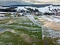
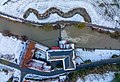
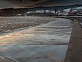
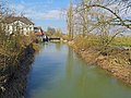
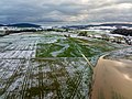
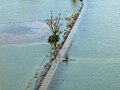
Media in category "Landschaftsschutzgebiet Südlicher Itzgrund"
The following 35 files are in this category, out of 35 total.
-
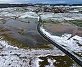
 Hemmendorf Hochwasser 2011 1320653.jpg 3,945 × 2,959; 7.32 MB
-
 Hemmendorf Itzgrund Hochwasser Luftbild-20220109-RM-153016.jpg 5,272 × 3,948; 8.08 MB
-
 Hemmendorf Itzgrund Hochwasser Luftbild-20220109-RM-153733.jpg 4,477 × 3,353; 8.23 MB
-
 Hemmendorf Itzgrund Hochwasser Luftbild-20220109-RM-153839.jpg 5,232 × 3,918; 12.25 MB
-
 Hemmendorf Itzgrund Hochwasser Luftbild-20220109-RM-153953.jpg 5,272 × 3,948; 11.75 MB
-
 Hemmendorf Itzgrund Hochwasser Luftbild-20220109-RM-154128.jpg 5,272 × 3,593; 13.15 MB
-
 Hemmendorf Itzgrund Hochwasser Luftbild-20220109-RM-154156.jpg 5,272 × 3,948; 12.88 MB
-
 Hemmendorf Itzgrund Hochwasser Luftbild-20231228-RM-154744.jpg 3,992 × 2,503; 5.65 MB
-
 Hochwasser Hemmendorf Itzgrund 1320670.jpg 4,000 × 3,000; 7.6 MB
-
 Hochwasser Itzgrund Lahm 1320675.jpg 4,000 × 3,000; 8.77 MB
-
 Hochwasser Lahm Itzgrund 1320647.jpg 3,615 × 2,711; 4.88 MB
-
 Itz bei Recheldorf (1).jpg 3,812 × 2,892; 1.66 MB
-
 Itzgrund 159.jpg 4,000 × 3,000; 2.79 MB
-
 Itzgrund 172.jpg 4,000 × 3,000; 2.76 MB
-
 Itzgrund 173.jpg 4,000 × 3,000; 3.12 MB
-
 Itzgrund Hochwasser Luftbild-20220109-RM-153006.jpg 5,272 × 3,948; 10.52 MB
-
 Itzgrund Hochwasser Luftbild-20220109-RM-153024.jpg 5,272 × 3,948; 11.51 MB
-
 Itzgrund Hochwasser Luftbild-20220109-RM-153133.jpg 5,272 × 3,948; 6.69 MB
-
 Itzgrund Hochwasser Luftbild-20220109-RM-153319.jpg 5,272 × 3,948; 12.07 MB
-
 Itzgrund Hochwasser Luftbild-20220109-RM-153331.jpg 5,272 × 3,948; 10.28 MB
-
 Itzgrund Hochwasser Luftbild-20220109-RM-153422.jpg 5,272 × 3,948; 11.26 MB
-
 Itzgrund Hochwasser Luftbild-20220109-RM-153522.jpg 5,272 × 3,948; 18.46 MB
-
 Itzgrund Hochwasser Luftbild-20220109-RM-153550.jpg 5,272 × 3,948; 12.81 MB
-
 Itzgrund Hochwasser Luftbild-20220109-RM-153646.jpg 5,272 × 3,948; 5.17 MB
-
 Itzgrund Hochwasser Luftbild-20220109-RM-153708.jpg 5,272 × 3,948; 8.04 MB
-
 Lahm Itzgrund Hochwasser 2023-20231228-RM-154312.jpg 5,272 × 3,948; 8.15 MB
-
 Lahm Itzgrund Hochwasser 2023-20231228-RM-154451.jpg 3,992 × 2,992; 5.04 MB
-
 Lahm Itzgrund Hochwasser 2023-20231228-RM-154642.jpg 3,110 × 2,331; 4.82 MB
-
 Lahm Itzgrund Hochwasser 2023-20231228-RM-154657.jpg 3,992 × 2,992; 5.86 MB
-
 Lahm Itzgrund Hochwasser 2023-20231228-RM-154758.jpg 5,272 × 3,948; 6.71 MB
-
 Lahm Itzgrund Hochwasser 2023-20231228-RM-154817.jpg 3,992 × 2,992; 5.37 MB
-
 Lahm Itzgrund Hochwasser 2023-20231228-RM-154822.jpg 5,272 × 3,948; 8.67 MB
-
 Lahm Itzgrund Hochwasser Luftbild-20220109-RM-153036.jpg 5,016 × 3,756; 12.36 MB
-
 Lahm Itzgrund Hochwasser Luftbild-20220109-RM-154205.jpg 4,843 × 3,948; 11.26 MB
-
 Lahm Itzgrund Luftbild-20220109-RM-153823.jpg 4,750 × 2,660; 8.45 MB


.jpg)


