Category:Landschaftsschutzgebiet Albrand
Jump to navigation
Jump to search
| Diese Kategorie repräsentiert ein Schutzgebiet nach Naturschutzrecht in Deutschland. |
|---|
| Diese Kategorie wurde nach einem klaren Schema angelegt, sie sollte nicht verschoben, gelöscht oder umkategorisiert werden. Sie ist unter anderem in dieser Uploadkarte hinterlegt. Beschreibung und Hintergründe auf der Seite des Wikiprojekts |
| Foto zu Wiki Loves Earth hochladen! - Seite von Wiki Loves Earth Deutschland |
This is the category of the protected area listed at WDPA under the ID 321396
|
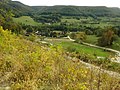
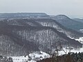
Deutsch: Das Landschaftsschutzgebiet Albrand (Schutzgebiets-Nr. 4.16.021) umfasst den gesamten Albrand im Landkreis Tübingen von Mössingen über Talheim bis Öschingen. Besonders erwähnt werden die reizvollen Erosionsformen im Juragestein.
protected landscape area in Baden-Württemberg, Germany  | |||||
| Upload media | |||||
| Instance of | |||||
|---|---|---|---|---|---|
| Location | Tübingen, Tübingen Government Region, Baden-Württemberg, Germany | ||||
| IUCN protected areas category | |||||
| Inception |
| ||||
| Area |
| ||||
 | |||||
LSG-Steckbrief der Landesanstalt für Umwelt, Messungen und Naturschutz Baden-Württemberg: https://rips-dienste.lubw.baden-wuerttemberg.de/rips/ripsservices/apps/naturschutz/schutzgebiete/steckbrief.aspx?id=4169003000009
Media in category "Landschaftsschutzgebiet Albrand"
The following 22 files are in this category, out of 22 total.
-
 Albtrauf bei Talheim.jpg 6,337 × 1,737; 6.86 MB
-
 Albtrauf Bergrutsch Talheim Schwaebische Alb.jpg 1,800 × 1,200; 2.4 MB
-
 Bergrutsch NO Öschingen LSG Albrand DSCI07341.jpg 2,560 × 1,920; 1.07 MB
-
 Bergrutsch NO Öschingen LSG Albrand DSCI0738 01.jpg 2,560 × 1,920; 1.45 MB
-
 Bergrutsch NO Öschingen LSG Albrand DSCI0739.jpg 2,560 × 1,920; 1.48 MB
-
 Bergrutsch NO Öschingen LSG Albrand DSCI0740.jpg 2,560 × 1,920; 1.35 MB
-
 Bergrutsch NO Öschingen LSG Albrand DSCI0743.jpg 2,560 × 1,920; 1.56 MB
-
 Bergrutsch NO Öschingen LSG Albrand Warnschild DSCI0742.jpg 2,560 × 1,920; 1.03 MB
-
 D-BW-TÜ Bergrutsch im Öschenbachtal; NSG + LSG.jpg 2,560 × 1,920; 938 KB
-
 Filsenberg bei Mössingen-Öschingen.jpg 4,928 × 3,264; 4.33 MB
-
 Filsenberg bei Öschingen.jpg 4,873 × 1,450; 2.32 MB
-
 Filsenberg von Talheim.jpg 4,288 × 2,848; 7.44 MB
-
 Hochfläche Meisenbühl im NSG Filsenberg, Waldhänge LSG Albrand; P1020149.jpg 3,648 × 2,736; 4 MB
-
 Mössingen-Öschingen.jpg 4,928 × 3,264; 4.11 MB
-
 Roßberg und Öschingen.jpg 4,928 × 3,264; 4.21 MB
-
 Talheim vom Farrenberg.jpg 4,288 × 1,639; 3.92 MB
-
 Unten NSG Öschenbachtal, Waldhänge LSG Albrand, P1020150.jpg 3,648 × 2,736; 3.89 MB
-
 Weg zur Olgahöhe.jpg 2,048 × 1,356; 2.21 MB
-
 Öschingen bei Mössingen.jpg 4,928 × 3,264; 4.82 MB
-
 Öschingen Bergrutsch 1.jpg 4,000 × 3,000; 2.25 MB
-
 Öschingen Bergrutsch 4+.jpg 4,000 × 3,000; 2.43 MB
-
 Öschingen und Roßberg.jpg 4,928 × 3,264; 3.99 MB


