Category:Landscape paintings by James Madison Alden
Jump to navigation
Jump to search
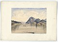
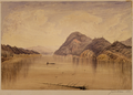
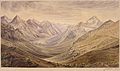
English: James Madison Alden was trained as a U.S. Navy cartographer, but he is known for his landscape paintings beginning on the en:West Coast of the United States and near the new U.S. - Canadian border while he was serving on the en:Coast Survey ship en:USCS Active in 1854 which was under command of his uncle, en:James Alden, Jr.[1][2][3]
References
[edit]- ↑ San Juan Island National Historical Park - James Alden (U.S. National Park Service). Retrieved on 29 December 2011.
- ↑ Landscapes and Waterscapes James Madison Alden Photos. Retrieved on 29 December 2011.
- ↑ California Historical Society. Retrieved on 29 December 2011.
Media in category "Landscape paintings by James Madison Alden"
The following 95 files are in this category, out of 95 total.
-

-
-
 "Josephs' Prairie". Head of Kootenay R - NARA - 102278908 (page 1).jpg 6,942 × 5,030; 3.93 MB
-
 "Josephs' Prairie". Head of Kootenay R - NARA - 102278908 (page 2).jpg 6,848 × 4,978; 2.7 MB
-

-

-
 "The Gates" from valley near E. entrance to Kishenehn Pass. looking W - NARA - 305544.jpg 3,900 × 2,700; 2.37 MB
-
 "Wind Mountain" Columbia R - NARA - 102278851 (page 1).jpg 6,958 × 5,019; 3.3 MB
-
 "Wind Mountain" Columbia R - NARA - 102278851 (page 1).png 5,609 × 3,597; 20.89 MB
-
 "Wind Mountain" Columbia River (above Cascades) looking up - NARA - 305502.jpg 3,400 × 2,200; 1.88 MB
-
 1st looking. Kootenay R - NARA - 102278914 (page 1).jpg 5,479 × 4,088; 2.21 MB
-
 1st looking. Kootenay R - NARA - 102278914 (page 2).jpg 5,392 × 4,073; 1.19 MB
-
 1st view Kootenay Valley - NARA - 102278887 (page 1).jpg 6,818 × 5,022; 3.28 MB
-
 1st view Kootenay Valley - NARA - 102278887 (page 2).jpg 6,694 × 4,875; 1.97 MB
-
 Active Pass - Saturna Group - View West - NARA - 102278815 (page 1).jpg 6,808 × 4,888; 2.85 MB
-
 Active Pass - Saturna Group - View West - NARA - 102278815 (page 2).jpg 6,836 × 4,938; 2.36 MB
-
 Active Passage, Saturna Group, Looking West WDL2718.png 1,433 × 1,024; 2.53 MB
-
 Active Passage. Saturna Group, looking West - NARA - 305490.jpg 4,200 × 3,000; 3.07 MB
-
 Ak-Kaph-Klek. Falls of the Kootenay - NARA - 102278920 (page 1).jpg 6,718 × 4,924; 3.21 MB
-
 Ak-Kaph-Klek. Falls of the Kootenay - NARA - 102278920 (page 2).jpg 6,674 × 4,943; 2.2 MB
-
 Ak-Knote-Kult-num Lake. E. side Rky. mts - NARA - 102278994 (page 1).jpg 6,796 × 4,996; 3.31 MB
-
 Ak-Knote-Kult-num Lake. E. side Rky. mts - NARA - 102278994 (page 2).jpg 6,822 × 4,999; 2.74 MB
-
 Akamina, Rky. mts - NARA - 102278980 (page 1).jpg 6,446 × 4,664; 3 MB
-
 Akleu Cache - NARA - 102278893 (page 1).jpg 5,371 × 4,101; 2.38 MB
-
 Akleu Cache. Near the Kootenay R. looking S - NARA - 305516.jpg 3,600 × 2,700; 3.63 MB
-

-

-
 Camp Kishenehn. Rky mts. Looking up the pass to N - NARA - 102278938 (page 1).jpg 5,442 × 4,029; 2.21 MB
-
 Camp Kootenay West (Narris' Camp) looking N.W - NARA - 305517.jpg 4,200 × 3,000; 3.75 MB
-
 Camp Kootenay West - NARA - 102278896 (page 1).jpg 6,886 × 4,787; 3.33 MB
-
 Camp Kootenay West - NARA - 102278896 (page 2).jpg 6,674 × 4,795; 1.98 MB
-
 Camp Mooyie (1 1-4 miles N. of 49th parallel). Peak bears N. 20 W - NARA - 305518.jpg 3,900 × 2,700; 3.54 MB
-
-
 Camp on Flathead River (49th parallel) looking up (W. 25. N.) - NARA - 305529.jpg 4,200 × 3,000; 3.63 MB
-

-

-
 Camp on stream near Waterton Lake. peak bears E. 30. S - NARA - 305549.jpg 3,900 × 2,700; 2.26 MB
-
 Camp Sumass - NARA - 102278836 (page 1).jpg 6,561 × 5,018; 3.12 MB
-
 Camp Sumass - NARA - 102278836 (page 2).jpg 6,802 × 4,990; 2.27 MB
-
 Camp Sumass. Sumass Prairie, looking N - NARA - 305497.jpg 4,200 × 3,000; 3.51 MB
-

-

-
 Cascade - Columbia R. left bank - NARA - 102278848 (page 1).jpg 5,551 × 4,102; 1.53 MB
-
 Cascade Kishenehn Pass (E side summit) Peak bears S. 50. E - NARA - 305543.jpg 3,900 × 2,700; 2.66 MB
-

-
 Cascade on left bank Columbia River (Cascades of the Columbia) - NARA - 305501.jpg 3,600 × 3,000; 2.59 MB
-

-
 Cañon of Palouse River - NARA - 102278854 (page 1).jpg 6,930 × 5,067; 2.61 MB
-
 Chelemta Depot. Cla-ka-na-kie mountains - NARA - 102278884 (page 1).jpg 6,774 × 5,018; 2.77 MB
-
 Chelemta Depot. From right bank of the Koontenay looking up - NARA - 305513.jpg 5,100 × 3,000; 4.14 MB
-

-

-
 Creek, Flathead mountains - NARA - 102278923 (page 1).jpg 5,324 × 4,007; 2.27 MB
-
 Creek, Flathead mountains - NARA - 102278923 (page 2).jpg 5,371 × 3,968; 1.42 MB
-
 Entrance Kishenehn Pass, from the E - NARA - 102278977 (page 1).jpg 5,389 × 3,973; 2.06 MB
-
 Entrance Kishenehn Pass, from the E - NARA - 102278977 (page 2).jpg 5,401 × 3,970; 1.77 MB
-

-

-
 Falls of the Kootenay (ak. Kaph-Kleh) from near the trail - NARA - 305525.jpg 4,200 × 3,000; 4 MB
-
 Great Falls on the Palouse River from summit of Cliffs on right bank - NARA - 305504.jpg 4,200 × 3,000; 3.58 MB
-

-
 Head Kellispelm Lake-near head of lake looking South. (Sienitic Cliffs) - NARA - 305512.jpg 3,600 × 3,000; 2.71 MB
-

-

-
 Kintla Mountains and lower lake, from spur of Boundary Mountain - NARA - 305534.jpg 4,200 × 3,000; 3.08 MB
-
 Kintla Mountains from the summit of Kishnehnehna - NARA - 305532.jpg 5,100 × 3,000; 3.56 MB
-
-
-

-
 Kootenay River. Junction with Elk River. View from trail on right bank - NARA - 305522.jpg 3,600 × 2,400; 2.45 MB
-
 Kootenay River. looking down from near Camp Kootenay East - NARA - 305523.jpg 3,900 × 2,700; 3.06 MB
-
 Lake on E. side summit Kishenehn Pass looking E - NARA - 305539.jpg 3,900 × 2,700; 2.17 MB
-
 Lake to the Westward of Akamina Lake. Peak bears S. 35. W - NARA - 305546.jpg 3,900 × 2,700; 2.73 MB
-
 Looking W. toward summit Kishenehn Pass left hand peak bears S. 10. W - NARA - 305542.jpg 4,200 × 3,000; 3.23 MB
-
 Mooyie River looking South (down) from the 49th parallel - NARA - 305519.jpg 3,900 × 2,700; 3.1 MB
-
-
 Mt. Kishenehn peak bears N. 50. W - NARA - 305535.jpg 3,900 × 2,700; 2.84 MB
-
 Plante's Crossing-Spokane River and Plains-trail runs N. N. E - NARA - 305507.jpg 3,600 × 2,400; 2.3 MB
-

-
 Rocky Mountain peaks from Camp on Josephs' Prairie. "Steeples" bear N.E - NARA - 305521.jpg 5,100 × 3,000; 4.67 MB
-
 Sandstone Mountain bearing E. 20. S. Kishenehn Pass (E. side of summit) - NARA - 305541.jpg 3,900 × 2,700; 2.61 MB
-
-

-

-

-
 Straits of Haro. Stewart's Island in the centre - NARA - 305491.jpg 4,200 × 3,000; 2.66 MB
-

-
 Summit of Cascade Mountains, from trail looking West - NARA - 305498.jpg 8,700 × 1,500; 3.3 MB
-

-
 Valley of Kootenay from hills near Akleu Cache (left bank) looking N.W - NARA - 305515.jpg 5,100 × 3,000; 3.97 MB
-

-

-
-

-


_looking_N._Trail_from_Palouse_R._to_Plants%27_Crossing_on_the_Spokane_-_NARA_-_305505.jpg)
.jpg)
.jpg)
_looking_N_-_NARA_-_305533.jpg)


.jpg)
.png)
_looking_up_-_NARA_-_305502.jpg)
.jpg)
.jpg)
.jpg)
.jpg)
.jpg)
.jpg)


.jpg)
.jpg)
.jpg)
.jpg)
.jpg)
.jpg)

_looking_N._50._E._across_Akamina_Lake_down_Akamina_Pass_toward_the_Sascatchawan_Plains_-_NARA_-_305545.jpg)
_in..._-_NARA_-_305531.jpg)
.jpg)
_looking_N.W_-_NARA_-_305517.jpg)
.jpg)
.jpg)
._Peak_bears_N._20_W_-_NARA_-_305518.jpg)
_-_NARA_-_305526.jpg)
_looking_up_(W._25._N.)_-_NARA_-_305529.jpg)
_looking_up_(W._25._N.)_-_NARA_-_102278932_(page_1).jpg)


.jpg)
.jpg)

_Kishenehn_or_Boundary_Pass._High_peak_bears_W_-_NARA_-_305540.jpg)
_-_NARA_-_305503.jpg)
.jpg)
_Peak_bears_S._50._E_-_NARA_-_305543.jpg)

_-_NARA_-_305501.jpg)
_-_NARA_-_305500.jpg)
.jpg)
.jpg)

.jpg)
.jpg)
.jpg)
.jpg)
.jpg)
.jpg)

.jpg)
_from_near_the_trail_-_NARA_-_305525.jpg)


_-_NARA_-_305512.jpg)


_from_trail_up_the_pass_looking_N._60._E_-_NARA_-_305537.jpg)
_and_Kishenehn_Pass_from_summit_of_Pass_looking_South_-_NARA_-_305538.jpg)
_looking_S._(down)_from_left_bank_-_NARA_-_305524.jpg)


_from_the_49th_parallel_-_NARA_-_305519.jpg)


_from_the_summit_of_Flathead_Pass._Boundary_mountain_bears_N._50._E_-_NARA_-_305528.jpg)

_-_NARA_-_305541.jpg)


_Military_Road_from_Colville_to_Walla_Walla_-_NARA_-_305506.jpg)


_looking_N.W_-_NARA_-_305515.jpg)


