Category:Lancierskazerne (Tilburg)
Jump to navigation
Jump to search
| Object location | | View all coordinates using: OpenStreetMap |
|---|
 | |||||
| Upload media | |||||
| Instance of | |||||
|---|---|---|---|---|---|
| Location | Tilburg, North Brabant, Netherlands | ||||
| Street address |
| ||||
| Located on street |
| ||||
| Country of origin | |||||
| Heritage designation |
| ||||
 | |||||
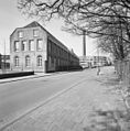
Nederlands: Gedeelte van het voormalig fabriekscomplex van de textielfabriek Van den Bergh Krabbendam. Gebouwd in 1842 als Lancierskazerne; in 1859 in gebruik genomen als textielfabriek
|
This is a category about rijksmonument number 35719
|
| Address |
|
Media in category "Lancierskazerne (Tilburg)"
The following 18 files are in this category, out of 18 total.
-
 35719 Lancierskazerne.jpg 3,000 × 2,345; 6.37 MB
-
 Exterieur GEDENKSTEEN - Tilburg - 20288399 - RCE.jpg 1,200 × 781; 327 KB
-
 Exterieur HOOFDGEBOUW, ACHTERGEVEL - Tilburg - 20288396 - RCE.jpg 1,200 × 784; 207 KB
-
 Exterieur HOOFDGEBOUW, INGANGSPARTIJ - Tilburg - 20288394 - RCE.jpg 1,200 × 777; 220 KB
-
 Exterieur HOOFDGEBOUW, VOORGEVEL - Tilburg - 20288393 - RCE.jpg 1,200 × 788; 170 KB
-
 Exterieur LINKER ZIJGEVEL - Tilburg - 20288398 - RCE.jpg 1,200 × 788; 227 KB
-
 Exterieur OVERZICHT BINNENPLAATS - Tilburg - 20288397 - RCE.jpg 1,200 × 788; 177 KB
-
 Exterieur RECHTER ZIJGEVEL, ACHTERGEVEL - Tilburg - 20288395 - RCE.jpg 1,200 × 785; 203 KB
-
 Lancierskazerne schoorsteen 2014 - 2.JPG 3,264 × 4,928; 9.89 MB
-
 Lancierskazerne schoorsteen 2014.JPG 4,928 × 3,264; 5.12 MB
-
 Lancierskazerne.jpg 3,648 × 2,736; 2.13 MB
-
 Milicien du 1er Lancier en 1914.jpg 1,500 × 2,100; 2.37 MB
-

-
 Overzicht voorgevel en linker zijgevel voormalig kazerne - Tilburg - 20344120 - RCE.jpg 1,185 × 1,200; 397 KB
-
 Overzicht voorgevel en linker zijgevel voormalig kazerne - Tilburg - 20344122 - RCE.jpg 1,183 × 1,200; 282 KB
-
 Overzicht voorgevel voormalig kazerne - Tilburg - 20344118 - RCE.jpg 1,197 × 1,200; 333 KB
-
 Overzicht voorgevel voormalig kazerne - Tilburg - 20344121 - RCE.jpg 1,200 × 1,159; 282 KB
-
 Overzicht voorgevel voormalig kazerne - Tilburg - 20344123 - RCE.jpg 1,200 × 1,197; 258 KB


