Category:Lake Ontario high water levels 2017
Jump to navigation
Jump to search
Media in category "Lake Ontario high water levels 2017"
The following 36 files are in this category, out of 36 total.
-
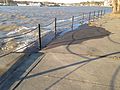
 BeachErosionSodusPointBeachPark.jpg 4,000 × 3,000; 2.46 MB
-
 ErodedAndFloodedPropertiesSodusPointNewYork.jpg 3,000 × 4,000; 2.37 MB
-
 FloodedBusinessIrondequoitCreekOutlet.jpg 4,000 × 3,000; 2.47 MB
-
 FloodedCrescentBeachPultneyvilleNewYork.jpg 4,000 × 3,000; 2.38 MB
-
 FloodedGreigStreetSodusPointNewYork.jpg 4,000 × 3,000; 2.45 MB
-
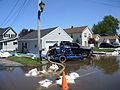
 FloodedHouseJoyLaneIrondequoitNewYork.jpg 4,000 × 3,000; 2.41 MB
-
 FloodedHouseRiverStreetRochesterNewYork.jpg 4,000 × 3,000; 2.48 MB
-
 FloodedMarinaJoyLaneIrondequoitNewYork.jpg 4,000 × 3,000; 2.45 MB
-
 FloodedParkingAreaIrondequoitBay.jpg 4,000 × 3,000; 2.32 MB
-
 FloodedPropertyPultneyvilleNewYork.jpg 4,000 × 3,000; 2.24 MB
-
 FloodedPultneyvilleYachtClub.jpg 4,000 × 3,000; 2.42 MB
-
 FloodedResidenceWithPumpSodusPointNewYork.jpg 4,000 × 3,000; 2.5 MB
-
 FloodedUSCGAuxiliaryBuildingRiverStreetRochesterNewYork.jpg 4,000 × 3,000; 2.43 MB
-
 FloodedVacationRentalsWithPumpSodusPointNewYork.jpg 4,000 × 3,000; 2.43 MB
-
 IrondequoitBayOutletLight.jpg 4,000 × 3,000; 2.23 MB
-
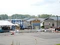
 Lake Ontario high water levels April 2017 Port of Rochester 01.jpg 3,264 × 2,448; 2.24 MB
-
 Lake Ontario high water levels April 2017 Port of Rochester 02.jpg 3,264 × 2,448; 3.78 MB
-
 Lake Ontario high water levels April 2017 Port of Rochester 03.jpg 3,264 × 2,448; 2.25 MB
-
 Lake Ontario high water levels April 2017 Port of Rochester 04.jpg 3,264 × 2,448; 2.33 MB
-
 Port of Rochester Genesee River Lake Ontario high water levels April 2017 01.jpg 3,264 × 2,448; 2.42 MB
-
 Port of Rochester Genesee River Lake Ontario high water levels April 2017 02.jpg 3,264 × 2,448; 2.31 MB
-
 Port of Rochester Genesee River Lake Ontario high water levels April 2017 03.jpg 3,264 × 2,448; 2.68 MB
-
 Port of Rochester Genesee River Lake Ontario high water levels April 2017 04.jpg 3,264 × 2,448; 2.49 MB
-
 ResidentsConferOnFloodedGreigStreetSodusPointNewYork.jpg 4,000 × 3,000; 2.43 MB
-
 RoadClosedDowntownSodusPointNewYork.jpg 4,000 × 3,000; 2.43 MB
-
 SandbaggedAndSubmergedMarinaSodusPointNewYork.jpg 4,000 × 3,000; 2.49 MB
-
 SandbaggedBusinessIrondequoitCreekOutletA.jpg 4,000 × 3,000; 2.49 MB
-
 SandbaggedBusinessIrondequoitCreekOutletB.jpg 3,000 × 4,000; 2.43 MB
-
 SandbagsBetweenGreigStreetAndGardinierLaneSodusPointNewYork.jpg 4,000 × 3,000; 2.41 MB
-
 SubmergedDocksMarlinsRestaurantSodusPointNewYork.jpg 4,000 × 3,000; 2.49 MB
-
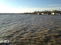
 SubmergedMarinaSodusBayNewYork.jpg 4,000 × 3,000; 2.44 MB
-
 SubmergedTreeBForemanParkWilliamsonNewYork.jpg 4,000 × 3,000; 2.36 MB
-
 SubmergedTreesIrondequoitBay.jpg 4,000 × 3,000; 2.18 MB
-
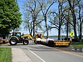 UnloadingSandbagsWickhamBlvdSodusPointNewYork.jpg 4,000 × 3,000; 2.32 MB
-
 WaveBatteredPropertyWilliamsonNewYork.jpg 4,000 × 3,000; 2.33 MB
-
 WaveBattersCaptainsMemorialPultneyvilleNewYork.jpg 4,000 × 3,000; 2.43 MB


