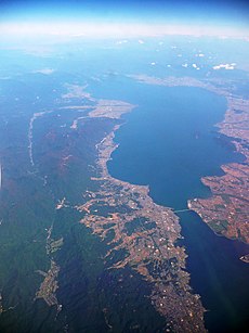
Category:Lake Biwa
Jump to navigation
Jump to search
freshwater lake in Japan | |||||
| Upload media | |||||
| Instance of |
| ||||
|---|---|---|---|---|---|
| Named after | |||||
| Located in protected area | |||||
| Location | |||||
| Heritage designation |
| ||||
| Inception |
| ||||
| Width |
| ||||
| Length |
| ||||
| Area |
| ||||
| Elevation above sea level |
| ||||
| Inflows |
| ||||
| Outflows | |||||
| Drainage basin |
| ||||
| Basin country | |||||
 | |||||
Subcategories
This category has the following 26 subcategories, out of 26 total.
- Fisheries of Lake Biwa (16 F)
- Maps of Lake Biwa (4 F)
A
B
C
D
- Dekeshima Lighthouse (3 F)
H
K
- Kaizu Osaki (22 F)
O
- Oki-no-Shiraishi (16 F)
- Otsu Kogan Nagisa Park (15 F)
P
T
- Take Island (Shiga) (24 F)
Y
- Yabase no Watashi (12 F)
Media in category "Lake Biwa"
The following 3 files are in this category, out of 3 total.
-
Symbol of Shiga prefecture.png 182 × 274; 31 KB
-
Top view of Lake Biwa.jpg 4,032 × 3,024; 2.29 MB
-
琵琶湖水生植物公園 - panoramio.jpg 4,416 × 3,312; 6.47 MB
Categories:
- Lakes of Shiga prefecture
- Pacific Ocean basins
- Biwako Quasi-National Park
- Ramsar sites in Japan
- Geography of Nagahama, Shiga
- Geography of Maibara, Shiga
- Geography of Hikone, Shiga
- Geography of Higashiomi, Shiga
- Geography of Omihachiman, Shiga
- Geography of Yasu, Shiga
- Geography of Moriyama, Shiga
- Geography of Kusatsu, Shiga
- Geography of Otsu
- Geography of Takashima, Shiga
- Tourism in Otsu
- Tributaries of the Yodo River


