Category:Laghey
Jump to navigation
Jump to search
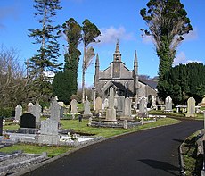
English: Laghey or Laghy (An Lathaigh in Irish) is a small village in County Donegal, Ireland, between Ballintra and Donegal Town. Laghey is one of three villages that makes up the parish of Drumholm, formerly a Civil and Church of Ireland parish, now only used as a division of the Roman Catholic Diocese of Raphoe. The village has a quarry, a supermarket, garden centre, filling station and car wash, two public houses, a church with a graveyard, an Orange Order hall, Curve Fitness for women, a post office, a phonebox, a new recycling centre, a Donegal County Council yard and salt depot, and a national school (St Eunan's NS). A take-away chip van also bases itself in the area on weekends and summer evenings. A number of Polish people work in the area, as well as German, English, and Latvian people. Laghey is also situated close to two of the most scenic beaches Ireland has to offer, namely Rossnowlagh and Murvagh. Murvagh is also the home to the Donegal Golf Club.
Gaeilge: An Lathaigh (nó Laghey i mBéarla), sráidbhaile i dTír Chonaill. Tá sé suite timpeall 10 míle ó Bhaile Dhún na nGall agus 15 míle ó Bhéal Átha Seanaidh.
village in Ireland | |||||
| Upload media | |||||
| Instance of | |||||
|---|---|---|---|---|---|
| Location | County Donegal, Ulster, Ireland | ||||
 | |||||
Media in category "Laghey"
The following 36 files are in this category, out of 36 total.
-
An Lathaigh 050605.jpg 1,589 × 2,276; 1.49 MB
-
Arches Bar, Laghey - geograph.org.uk - 2072212.jpg 640 × 480; 45 KB
-
Bi-lingual sign, Rathaneeny Park - geograph.org.uk - 2072264.jpg 640 × 480; 81 KB
-
Cottage near Laghey Co Donegal - geograph.org.uk - 149476.jpg 640 × 480; 78 KB
-
Farm near Laghey - geograph.org.uk - 2071541.jpg 640 × 480; 62 KB
-
Farmhouse on the L2195 at Laghy - geograph.org.uk - 3219530.jpg 1,024 × 547; 88 KB
-
House on the N15 at Laghey - geograph.org.uk - 5654322.jpg 640 × 427; 369 KB
-
Laghey Health Centre - geograph.org.uk - 2072219.jpg 640 × 480; 54 KB
-
Laghey Orange Hall - geograph.org.uk - 2071516.jpg 640 × 480; 57 KB
-
Laghy Barr - geograph.org.uk - 1002165.jpg 640 × 427; 102 KB
-
Limestone Quarry at Laghey Donegal - geograph.org.uk - 1401033.jpg 640 × 480; 129 KB
-
Limestone quarry at Laghy - geograph.org.uk - 1942395.jpg 640 × 480; 82 KB
-
Lough Nadarragh Co Donegal - geograph.org.uk - 40110.jpg 640 × 480; 107 KB
-
Main Street, Laghey - geograph.org.uk - 2072236.jpg 640 × 480; 52 KB
-
Main Street, Laghy - geograph.org.uk - 3533732.jpg 640 × 480; 56 KB
-
National Road 15 entering Laghey - geograph.org.uk - 5654318.jpg 640 × 427; 371 KB
-
O'Carolan's Pub, Laghey - geograph.org.uk - 2072233.jpg 640 × 480; 53 KB
-
Plaque, Laghey Orange Hall - geograph.org.uk - 2071518.jpg 640 × 480; 88 KB
-
Quarry faces at Laghy - geograph.org.uk - 1942403.jpg 640 × 480; 92 KB
-
R232, Pettigo Road, Laghey - geograph.org.uk - 2071534.jpg 640 × 480; 73 KB
-
Road blocked, Laghey - geograph.org.uk - 2072228.jpg 640 × 480; 55 KB
-
Robert Kee at Laghy, Co Donegal - geograph.org.uk - 3218919.jpg 1,024 × 750; 115 KB
-
Seven Arched Bridge at Laghy - geograph.org.uk - 830503.jpg 640 × 480; 113 KB
-
Seven Arched Bridge, Laghey - geograph.org.uk - 2071529.jpg 640 × 480; 96 KB
-
Seven arched bridge, Laghy - geograph.org.uk - 3533728.jpg 640 × 480; 94 KB
-
Shed on Old Laghy Road - geograph.org.uk - 806992.jpg 640 × 480; 72 KB
-
St Eunan's National School, Laghy - geograph.org.uk - 3247078.jpg 1,024 × 710; 128 KB
-
The N15 approaching Laghy - geograph.org.uk - 3247068.jpg 1,024 × 522; 93 KB
-
The Old School House on the L2195 at Laghy - geograph.org.uk - 3218933.jpg 1,024 × 629; 185 KB
-
The village of Laghy, Co Donegal - geograph.org.uk - 3218926.jpg 1,024 × 748; 131 KB
-
Total Service Station on the N15 at Laghy - geograph.org.uk - 3247075.jpg 1,024 × 608; 95 KB


