Category:Lage der A 12-13 (Groningen)
Jump to navigation
Jump to search
| Object location | | View all coordinates using: OpenStreetMap |
|---|
 | |||||
| Upload media | |||||
| Instance of | |||||
|---|---|---|---|---|---|
| Location | Groningen, Netherlands | ||||
| Street address |
| ||||
| Located on street | |||||
| Heritage designation |
| ||||
 | |||||
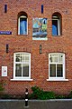
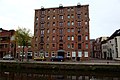
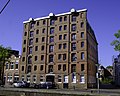
Nederlands: Lage der A 12-13 (hoek Dwarsstraat, 1885, uitgebreid in 1903, rm 485842), Groningen, een tot woonruimte verbouwd pakhuis
|
This is a category about rijksmonument number 485842
|
| Address |
|
Media in category "Lage der A 12-13 (Groningen)"
The following 14 files are in this category, out of 14 total.
-
 18541 Lage der A 14 Groningen NL.jpg 5,146 × 3,428; 7.75 MB
-
 20220509 Stadsgezicht met sneeuw door Hendrik Werkman (1922) Groningen.jpg 2,587 × 3,252; 1.47 MB
-
 20220509 Werkmanhuis hoek Dwarsstraat Lage der Aa Groningen.jpg 3,456 × 5,184; 3.66 MB
-
 485842 Lage der A 12-13 Groningen NL.jpg 5,634 × 3,753; 11.19 MB
-
 Groningen - Lage der A 12-13.jpg 5,000 × 4,000; 11.45 MB
-
 Overzicht - Groningen - 20093675 - RCE.jpg 1,200 × 956; 238 KB
-
 Overzicht - Groningen - 20093933 - RCE.jpg 1,200 × 811; 208 KB
-
 Overzicht - Groningen - 20094005 - RCE.jpg 1,200 × 955; 268 KB
-

-
 Overzicht Dwarsstraat - Groningen - 20092190 - RCE.jpg 1,192 × 1,200; 318 KB
-
 Overzicht hoek Lage der Aa - Groningen - 20093678 - RCE.jpg 1,200 × 950; 189 KB
-
 Overzicht Lage der A - Groningen - 20092283 - RCE.jpg 1,190 × 1,200; 322 KB
-
 Overzicht Lage der A - Hoge der A. - Groningen - 20092285 - RCE.jpg 1,190 × 1,200; 296 KB
-
 Voorgevel - Groningen - 20094007 - RCE.jpg 1,200 × 1,188; 265 KB

_Groningen.jpg)


