Category:Lage Gouwe 140, Gouda
Jump to navigation
Jump to search
| Object location | | View all coordinates using: OpenStreetMap |
|---|
Nederlands: Bananenpakhuis, Lage Gouwe 140
building in Gouda, Netherlands  | |||||
| Upload media | |||||
| Instance of |
| ||||
|---|---|---|---|---|---|
| Location | Gouda, South Holland, Netherlands | ||||
| Street address |
| ||||
| Located on street | |||||
| Heritage designation |
| ||||
 | |||||
|
This is a category about rijksmonument number 16797
|
| Address |
|
Media in category "Lage Gouwe 140, Gouda"
The following 11 files are in this category, out of 11 total.
-
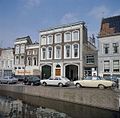
 Lage Gouwe 140 Gouda.jpg 908 × 1,824; 472 KB
-
 Lage Gouwe 140, Gouda (01).jpg 2,432 × 3,555; 4.99 MB
-
 Lage Gouwe 140, Gouda (02).jpg 4,307 × 2,409; 6.79 MB
-
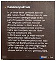 Lage Gouwe 140, Gouda. Informatiebord.jpg 1,951 × 2,151; 2.3 MB
-

-
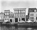
 Overzicht van de voorgevels - Gouda - 20379869 - RCE.jpg 1,200 × 1,180; 275 KB
-

-
 Voorgevel - Gouda - 20082485 - RCE.jpg 1,200 × 960; 205 KB
-
 Voorgevel - Gouda - 20082486 - RCE.jpg 1,200 × 957; 174 KB
-
 Voorgevel - Gouda - 20082487 - RCE.jpg 1,200 × 965; 195 KB
-
 Voorgevels - Gouda - 20082321 - RCE.jpg 1,200 × 804; 199 KB
.jpg)
.jpg)


