Category:Lachine Light Tower - Rear Range
Jump to navigation
Jump to search
| Object location | | View all coordinates using: OpenStreetMap |
|---|
This category is for a cultural heritage site in Canada, number 10877
|
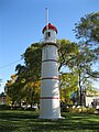
lighthouse in Quebec, Canada  | |||||
| Upload media | |||||
| Instance of | |||||
|---|---|---|---|---|---|
| Location | Montreal, Urban agglomeration of Montreal, Montreal Region, Quebec, Canada | ||||
| Heritage designation | |||||
 | |||||
English: The Light Tower (Rear) is one of two identically designed towers in St. Louis Park, a municipal recreation space on the waterfront, in Lachine, Quebec, Canada.
Français : Le phare (arrière) est l’un de deux phares jumeaux qui se dressent dans le parc Saint-Louis, secteur de loisirs municipal situé au bord de l’eau, à Lachine, Québec, Canada.
Media in category "Lachine Light Tower - Rear Range"
The following 7 files are in this category, out of 7 total.
-
 Phare arriere Lachine 01.jpg 4,000 × 3,000; 4.47 MB
-
 Phare arriere Lachine 02.jpg 4,000 × 3,000; 4.4 MB
-
 Phare arriere Lachine 03.jpg 3,000 × 4,000; 3.47 MB
-
 Phare arriere Lachine 04.jpg 3,000 × 4,000; 3.69 MB
-
 Phare arriere Lachine 05.jpg 3,000 × 4,000; 3.64 MB
-
 Phare arriere Lachine 06.jpg 3,000 × 4,000; 3.82 MB
-
 Phare arriere Lachine 07.jpg 4,000 × 3,000; 5.57 MB


