Category:Lac de Bouvent
Jump to navigation
Jump to search
| Object location | | View all coordinates using: OpenStreetMap |
|---|
|
Lac de Bouvent has an entry on OpenStreetMap (show). |
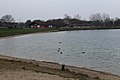
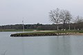
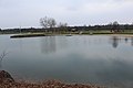
lake in Bourg-en-Bresse, France  | |||||
| Upload media | |||||
| Instance of | |||||
|---|---|---|---|---|---|
| Location | Parc de loisirs de Bouvent, Bourg-en-Bresse, arrondissement of Bourg-en-Bresse, Ain, Auvergne-Rhône-Alpes, Metropolitan France, France | ||||
| Elevation above sea level |
| ||||
 | |||||
Media in category "Lac de Bouvent"
The following 49 files are in this category, out of 49 total.
-
 Bouvent Bourg en Bresse.jpg 4,000 × 3,000; 2.58 MB
-
 Lac Bouvent Bourg Bresse 1.jpg 5,184 × 3,456; 6.24 MB
-
 Lac Bouvent Bourg Bresse 10.jpg 5,184 × 3,456; 5.37 MB
-
 Lac Bouvent Bourg Bresse 11.jpg 5,184 × 3,456; 4.74 MB
-
 Lac Bouvent Bourg Bresse 12.jpg 5,184 × 3,456; 6.84 MB
-
 Lac Bouvent Bourg Bresse 13.jpg 5,184 × 3,456; 4.73 MB
-
 Lac Bouvent Bourg Bresse 14.jpg 5,184 × 3,456; 4.9 MB
-
 Lac Bouvent Bourg Bresse 15.jpg 5,184 × 3,456; 5.79 MB
-
 Lac Bouvent Bourg Bresse 16.jpg 5,184 × 3,456; 4.38 MB
-
 Lac Bouvent Bourg Bresse 17.jpg 5,184 × 3,456; 7.04 MB
-
 Lac Bouvent Bourg Bresse 18.jpg 5,184 × 3,456; 8.83 MB
-
 Lac Bouvent Bourg Bresse 19.jpg 5,184 × 3,456; 6.73 MB
-
 Lac Bouvent Bourg Bresse 2.jpg 5,184 × 3,456; 6.14 MB
-
 Lac Bouvent Bourg Bresse 20.jpg 5,184 × 3,456; 5.84 MB
-
 Lac Bouvent Bourg Bresse 21.jpg 5,184 × 3,456; 7.65 MB
-
 Lac Bouvent Bourg Bresse 22.jpg 5,184 × 3,456; 8.9 MB
-
 Lac Bouvent Bourg Bresse 23.jpg 5,184 × 3,456; 8.31 MB
-
 Lac Bouvent Bourg Bresse 24.jpg 5,184 × 3,456; 5.53 MB
-
 Lac Bouvent Bourg Bresse 25.jpg 5,184 × 3,456; 5.11 MB
-
 Lac Bouvent Bourg Bresse 26.jpg 9,292 × 2,781; 23.85 MB
-
 Lac Bouvent Bourg Bresse 27.jpg 5,184 × 3,456; 6.5 MB
-
 Lac Bouvent Bourg Bresse 28.jpg 5,184 × 3,456; 5.58 MB
-
 Lac Bouvent Bourg Bresse 29.jpg 5,184 × 3,456; 5.3 MB
-
 Lac Bouvent Bourg Bresse 3.jpg 5,184 × 3,456; 6.35 MB
-
 Lac Bouvent Bourg Bresse 30.jpg 5,184 × 3,456; 6.02 MB
-
 Lac Bouvent Bourg Bresse 31.jpg 5,184 × 3,456; 6.99 MB
-
 Lac Bouvent Bourg Bresse 32.jpg 5,184 × 3,456; 5.88 MB
-
 Lac Bouvent Bourg Bresse 33.jpg 5,184 × 3,456; 5.65 MB
-
 Lac Bouvent Bourg Bresse 34.jpg 5,184 × 3,456; 5.3 MB
-
 Lac Bouvent Bourg Bresse 35.jpg 5,184 × 3,456; 5.38 MB
-
 Lac Bouvent Bourg Bresse 36.jpg 5,184 × 3,456; 8.58 MB
-
 Lac Bouvent Bourg Bresse 37.jpg 5,184 × 3,456; 6.04 MB
-
 Lac Bouvent Bourg Bresse 38.jpg 5,184 × 3,456; 5.75 MB
-
 Lac Bouvent Bourg Bresse 39.jpg 5,184 × 3,456; 6.15 MB
-
 Lac Bouvent Bourg Bresse 4.jpg 5,184 × 3,456; 5.32 MB
-
 Lac Bouvent Bourg Bresse 40.jpg 5,184 × 3,456; 6.8 MB
-
 Lac Bouvent Bourg Bresse 41.jpg 5,184 × 3,456; 6.64 MB
-
 Lac Bouvent Bourg Bresse 42.jpg 5,184 × 3,456; 6.57 MB
-
 Lac Bouvent Bourg Bresse 43.jpg 5,184 × 3,456; 6.64 MB
-
 Lac Bouvent Bourg Bresse 44.jpg 5,184 × 3,456; 6.44 MB
-
 Lac Bouvent Bourg Bresse 45.jpg 5,184 × 3,456; 5.52 MB
-
 Lac Bouvent Bourg Bresse 46.jpg 5,184 × 3,456; 7.56 MB
-
 Lac Bouvent Bourg Bresse 47.jpg 5,184 × 3,456; 6.57 MB
-
 Lac Bouvent Bourg Bresse 48.jpg 5,184 × 3,456; 6.61 MB
-
 Lac Bouvent Bourg Bresse 5.jpg 5,184 × 3,456; 6.32 MB
-
 Lac Bouvent Bourg Bresse 6.jpg 5,184 × 3,456; 7.31 MB
-
 Lac Bouvent Bourg Bresse 7.jpg 5,184 × 3,456; 5.4 MB
-
 Lac Bouvent Bourg Bresse 8.jpg 12,211 × 2,930; 30.77 MB
-
 Lac Bouvent Bourg Bresse 9.jpg 5,184 × 3,456; 5.25 MB


