Category:La Panera (Castellserà)
Jump to navigation
Jump to search
| Object location | | View all coordinates using: OpenStreetMap |
|---|
cultural property in Castellserà, Spain  | |||||
| Upload media | |||||
| Instance of | |||||
|---|---|---|---|---|---|
| Location | Castellserà, Urgell, Ponent, Lleida Province, Catalonia | ||||
| Street address |
| ||||
| Architectural style | |||||
| Heritage designation | |||||
| Inception |
| ||||
| Elevation above sea level |
| ||||
 | |||||
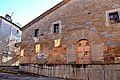
Català: La Panera, antic graner del monestir de Poblet, la Cistella, la Garuta. C. de Santa Maria (Castellserà)
This is a category about a monument listed in the Catalan heritage register of Béns Culturals d'Interès Nacional and the Spanish heritage register of Bienes de Interés Cultural under the reference RI-51-0010571. |
Media in category "La Panera (Castellserà)"
The following 4 files are in this category, out of 4 total.
-
 LA PANERA - CASTELLSERÀ - IB-570.jpg 1,536 × 2,048; 1.13 MB
-
 LA PANERA - CASTELLSERÀ - IB-572.jpg 2,048 × 1,536; 998 KB
-
 La Panera, Castellserà, Urgell.jpg 6,000 × 4,000; 9.5 MB
-
 Panera de Castellserà.jpg 3,072 × 1,728; 2.23 MB


