Category:Lötschberg-Panoramaweg
Jump to navigation
Jump to search

 | |||||
| Upload media | |||||
| Instance of | |||||
|---|---|---|---|---|---|
| Location |
| ||||
| Maintained by |
| ||||
| Part of the series |
| ||||
| Length |
| ||||
| Mountain range | |||||
| official website | |||||
| |||||
![]() Switzerland -
Switzerland - ![]() Canton of Bern
Canton of Bern ![]() Valais
Valais
Deutsch: Regionale Schweizer Wanderroute 56 in den Berner Alpen.
Media in category "Lötschberg-Panoramaweg"
The following 21 files are in this category, out of 21 total.
-
 56-Fafleralp-NO.jpg 4,140 × 2,328; 2.68 MB
-
 56-Lötsch-BE.jpg 140 × 140; 14 KB
-
 56-Lötschberg.jpg 140 × 140; 14 KB
-
 56-Schwarzsee.jpg 800 × 515; 270 KB
-
 56-Tellialp.jpg 3,008 × 1,692; 1.72 MB
-
 56-Wyssriedbann.jpg 4,240 × 2,832; 7.61 MB
-
 Berghaus Lauchern.jpg 3,104 × 1,746; 3.21 MB
-
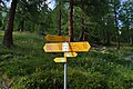
 Hiking sign near Hockuchriz (16604499380).jpg 3,456 × 5,184; 3.94 MB
-
 Kapelle Wildi.jpg 3,104 × 1,746; 3.22 MB
-
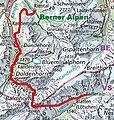 Karte-56.jpg 449 × 474; 177 KB
-
 Lötschegletscher02.jpg 1,600 × 1,200; 678 KB
-
 Schwarzsee O-S.jpg 6,315 × 2,924; 5.58 MB
-
 Schwarzsee-O.jpg 3,104 × 1,746; 3.42 MB
-
 Tellistafel.jpg 4,240 × 2,832; 6.41 MB
-
 Wanderwegweiser Gfelalp 1847.jpg 3,539 × 2,013; 672 KB
-
 Wanderwegweiser Kandersteg 1176.jpg 2,537 × 3,840; 1.24 MB
-
 Wanderwegweiser Schwarzsee 1858.jpg 2,892 × 1,192; 444 KB
-
 Wanderwegweiser Selde 1545.jpg 3,364 × 4,792; 2.54 MB
-
 Wanderwegweiser Tellialp 1865.jpg 2,624 × 2,792; 1.18 MB
-
 Wanderwegweiser Weritzalp 2099.jpg 2,668 × 1,752; 952 KB
-
 Wanderwegweiser Wyssriedbann 2028.jpg 4,324 × 2,556; 1.58 MB


.jpg)


