Category:Lösch-Brunnen (Karl Indermühle 1927)
Jump to navigation
Jump to search
| Object location | | View all coordinates using: OpenStreetMap |
|---|
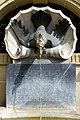
Deutsch: Der Lösch-Brunnen ist ein Brunnen von 1927 von Karl Indermühle (1877–1933) zur Erinnerung an den Schumachermeister und Brunnenförderer HEINR PHILIPP LÖSCH – Schreibweise auf Widmungstafel – (1826–1896) auf der Münsterplattform östlich vom Gittertor zur Münstergasse in der Altstadt von Bern in der Schweiz.
memorial and drinking fountain in the city of Bern, Switzerland   | |||||
| Upload media | |||||
| Instance of | |||||
|---|---|---|---|---|---|
| Part of | |||||
| Commemorates | |||||
| Made from material | |||||
| Genre | |||||
| Location | Münster platform, Green Quarter, Inner City, Bern, Bern-Mittelland administrative district, Bernese Mittelland administrative region, Bern, Switzerland | ||||
| Creator | |||||
| Owned by | |||||
| Operator | |||||
| Inception |
| ||||
| Elevation above sea level |
| ||||
 | |||||
Media in category "Lösch-Brunnen (Karl Indermühle 1927)"
The following 14 files are in this category, out of 14 total.
-
 Bern (4917109458).jpg 660 × 996; 465 KB
-
 Bern - panoramio (73).jpg 2,592 × 3,456; 3.19 MB
-
 Lösch-Brunnen 01.jpg 4,400 × 2,928; 8.72 MB
-
 Lösch-Brunnen 02.jpg 4,200 × 2,794; 7.95 MB
-
 Lösch-Brunnen 03.jpg 4,300 × 2,862; 8.27 MB
-
 Lösch-Brunnen 04.jpg 4,592 × 3,056; 9.29 MB
-
 Lösch-Brunnen 05.jpg 2,995 × 4,500; 8.81 MB
-
 Lösch-Brunnen 06.jpg 2,995 × 4,500; 9.49 MB
-
 Lösch-Brunnen 07.jpg 2,928 × 4,400; 8.84 MB
-
 Lösch-Brunnen 08.jpg 4,592 × 3,056; 11.11 MB
-
 Lösch-Brunnen 09.jpg 4,200 × 2,794; 10.1 MB
-
 Lösch-Brunnen 10.jpg 4,400 × 2,928; 12.28 MB
-
 Münstergasse 3 Bern 20230530 0204.jpg 6,786 × 4,720; 24.35 MB
-
 Münsterplattform Brunnen.jpg 2,144 × 1,424; 484 KB
.jpg)
.jpg)


