Category:Löntschtobel bridge
Jump to navigation
Jump to search
| Object location | | View all coordinates using: OpenStreetMap |
|---|
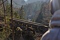
Deutsch: (obere) Löntschtobel-Brücke, Löntschtobelbrücke, Riedern, Glarus
|
This is a category about a cultural property of regional significance in Switzerland with KGS number 2802
|
 | |||||
| Upload media | |||||
| Instance of | |||||
|---|---|---|---|---|---|
| Part of | |||||
| Location | Riedern, Glarus, Switzerland | ||||
| Crosses | |||||
| Heritage designation | |||||
 | |||||
Media in category "Löntschtobel bridge"
The following 7 files are in this category, out of 7 total.
-
 Löntschtobelbrücke, Glarus, in 2015.jpg 5,496 × 3,670; 18.05 MB
-
 Löntschtobelbrücke, Glarus, in March 2016.jpg 5,495 × 3,670; 12.59 MB
-
 Löntschtobelbrücke, Glarus, Oct 2015.jpg 5,495 × 3,669; 6.41 MB
-
 Löntschtobelbrücke, Glarus, plan view with Mavic Pro 2, January 2019.jpg 5,464 × 3,640; 19.36 MB
-
 Löntschtobelbrücke.jpg 3,000 × 2,250; 5.99 MB
-
 Riedern Löntschtobelbrücke, Gemeinde Glarus (19574866771).jpg 5,634 × 3,753; 13.51 MB
-
 Überlegen & Bewegen.jpg 5,466 × 3,637; 23.9 MB


.jpg)
