Category:Längenmühlbach
Jump to navigation
Jump to search
- (de) Längenmühlbach
Deutsch: Der Längenmühlbach, auf amtlichen Flurkarten teilweise auch nur Mühlbach, ist ein 68,12 Kilometer langer Mühlkanal parallel zum Unterlauf der Isar in Niederbayern.
 | |||||
| Upload media | |||||
| Instance of | |||||
|---|---|---|---|---|---|
| Location | Bavaria, Germany | ||||
| Length |
| ||||
| Origin of the watercourse |
| ||||
| Mouth of the watercourse | |||||
| Drainage basin | |||||
 | |||||
Media in category "Längenmühlbach"
The following 11 files are in this category, out of 11 total.
-
 Gänsmühlbach Mündung 1.JPG 3,072 × 2,304; 2.38 MB
-
 Gänsmühlbach Mündung 2.JPG 3,072 × 2,304; 2.81 MB
-
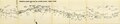
 Isar-Mühlbäche Karte Sailer 1930.jpg 15,701 × 3,174; 36.78 MB
-
 Isar-Mühlbäche Karte Sailer 1930.pdf 33,643 × 6,800; 7.8 MB
-
 Josef Sailer - Isar-Seitenkanäle b4.pdf 1,239 × 1,752, 88 pages; 71.4 MB
-
 Josef Sailer - Isar-Seitenkanäle b4a.pdf 1,237 × 1,752, 88 pages; 127.99 MB
-
 Josef Sailer - Isar-Seitenkanäle.pdf 1,237 × 1,814, 93 pages; 195.19 MB
-
 Laengenmuehlbach bei Mamming.jpg 1,233 × 916; 858 KB
-
 Längenmühlbach 10.JPG 3,072 × 2,304; 2.63 MB
-
 Silber-Weide Mamming.JPG 1,248 × 936; 802 KB
-
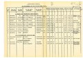 Verzeichnis der Seitenkanäle der Isar mit den Triebwerken.pdf 7,516 × 5,314; 961 KB


