Category:L'Agnone (Stazzona)
Jump to navigation
Jump to search
|
L'Agnone (Stazzona) has an entry on OpenStreetMap (show). |
human settlement in the Italian municipality of Stazzona ,_towards_Badalucco.jpg) _03.jpg)  | |||||
| Upload media | |||||
| Instance of |
| ||||
|---|---|---|---|---|---|
| Location | Stazzona, Province of Como, Lombardy, Italy | ||||
| Elevation above sea level |
| ||||
 | |||||
Subcategories
This category has the following 2 subcategories, out of 2 total.
F
- Fountain in L'Agnone (5 F)
M
Media in category "L'Agnone (Stazzona)"
The following 18 files are in this category, out of 18 total.
-
 Along VML4 departs right the track towards Cozzonale.jpg 4,608 × 3,456; 10.16 MB
-
 Arriving in L'Agnone (Stazzona), towards Badalucco.jpg 5,818 × 2,392; 6.19 MB
-
 Building in L'Agnone (Stazzona).jpg 4,239 × 3,534; 7.52 MB
-
 Buildings in L'Agnone (Stazzona).jpg 4,122 × 2,712; 4.92 MB
-
 L'Agnone (Stazzona) , VML4 in direction of Nessa.jpg 5,956 × 2,902; 9.59 MB
-
 Panoramic view from L'Agnone (Stazzona).jpg 14,590 × 3,138; 22.12 MB
-
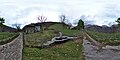
 Photosphere in L'Agnone (Stazzona) 01.jpg 5,322 × 2,661; 6.06 MB
-
 Photosphere in L'Agnone (Stazzona) 02.jpg 5,322 × 2,661; 4.91 MB
-
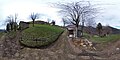
 Photosphere in L'Agnone (Stazzona) 03.jpg 5,322 × 2,661; 4.85 MB
-
 Photosphere in L'Agnone (Stazzona) 04.jpg 5,322 × 2,661; 4.46 MB
-
 Photosphere in L'Agnone (Stazzona) 05.jpg 5,322 × 2,661; 4.74 MB
-
 Photosphere in L'Agnone (Stazzona) 06.jpg 5,322 × 2,661; 5.62 MB
-
 Photosphere in L'Agnone (Stazzona) 07.jpg 5,322 × 2,661; 4.86 MB
-
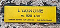 Place name sign L'Agnone.jpg 3,003 × 1,395; 2.39 MB
-
 Route marker VML4 by Madonna del Sasso Rondolino.jpg 4,608 × 3,456; 8.72 MB
-
 VML4 in L'Agnone (Stazzona), direction towards Badalucco.jpg 4,608 × 3,456; 9.15 MB
-
 VML4 in L'Agnone (Stazzona), direction towards Nessa.jpg 4,608 × 3,456; 7.5 MB
-
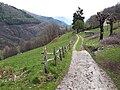
 VML4 towards L'Agnone.jpg 4,608 × 3,456; 9.59 MB

.jpg)
.jpg)
_,_VML4_in_direction_of_Nessa.jpg)
_01.jpg)
_02.jpg)
_03.jpg)
_04.jpg)
_05.jpg)
_06.jpg)
_07.jpg)

,_direction_towards_Badalucco.jpg)
,_direction_towards_Nessa.jpg)

.jpg)