Category:Kwan Tai Temple, Yi Au Tsai
Jump to navigation
Jump to search
| Object location | | View all coordinates using: OpenStreetMap |
|---|
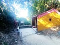
English: Kwan Tai Temple (關帝廟). At Western White Tiger Pass (西白虎坳) aka. Yi Au Tsai (二坳仔). Along MacLehose Trail Section 10, Tai Lam. The temple is part of a set of three temples built by villagers at the north of today's Tai Lam Chung Reservoir, on the main routes to Tin Fu Tsai, Tai Hang Village (大坑村) and Kan Uk Tei with a will that their trips to the markets would be safe. The other two temples are Ma Neung Temple (媽娘廟, a Tin Hau Temple), and Pak Kung Temple (伯公廟) aka. White Tiger Pass Temple (白虎坳廟).
Media in category "Kwan Tai Temple, Yi Au Tsai"
The following 12 files are in this category, out of 12 total.
-
 Kwan Tai Temple, Yi Au Tsai 01.jpg 2,592 × 1,944; 1.22 MB
-
 Kwan Tai Temple, Yi Au Tsai 02.jpg 4,000 × 3,000; 2.79 MB
-
 Kwan Tai Temple, Yi Au Tsai 03.jpg 4,000 × 3,000; 3.99 MB
-
 Kwan Tai Temple, Yi Au Tsai 04.jpg 2,562 × 1,922; 1,023 KB
-
 Kwan Tai Temple, Yi Au Tsai 05.jpg 2,592 × 1,944; 1.49 MB
-
 Kwan Tai Temple, Yi Au Tsai 06.jpg 2,592 × 1,944; 1.77 MB
-
 Kwan Tai Temple, Yi Au Tsai 07.jpg 2,592 × 1,944; 1.23 MB
-
 Kwan Tai Temple, Yi Au Tsai 08.jpg 4,000 × 3,000; 2.92 MB
-
 Kwan Tai Temple, Yi Au Tsai 09.jpg 3,927 × 2,944; 1.12 MB
-
 Kwan Tai Temple, Yi Au Tsai 10.jpg 3,927 × 2,945; 1.72 MB
-
 Kwan Tai Temple, Yi Au Tsai 11.jpg 4,000 × 3,000; 6.08 MB
-
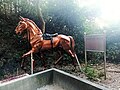
 赤兔神駒.jpg 4,032 × 3,024; 4.42 MB


