Category:Kwan Tai Temple, Tai Wo Hau
Jump to navigation
Jump to search
| Object location | | View all coordinates using: OpenStreetMap |
|---|
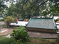
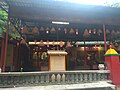
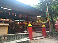
中文:大窩口關帝廟
Media in category "Kwan Tai Temple, Tai Wo Hau"
The following 21 files are in this category, out of 21 total.
-
 Kwan Tai Temple, Tai Wo Hau 01.jpg 4,160 × 3,120; 6.42 MB
-
 Kwan Tai Temple, Tai Wo Hau 02.jpg 4,160 × 3,120; 7.19 MB
-
 Kwan Tai Temple, Tai Wo Hau 03.jpg 4,160 × 3,120; 5.51 MB
-
 Kwan Tai Temple, Tai Wo Hau 04.jpg 4,160 × 3,120; 5.21 MB
-
 Kwan Tai Temple, Tai Wo Hau 05.jpg 4,065 × 3,049; 1.79 MB
-
 Kwan Tai Temple, Tai Wo Hau 06.jpg 4,160 × 3,120; 2.67 MB
-
 Kwan Tai Temple, Tai Wo Hau 07.jpg 4,160 × 3,120; 3.12 MB
-
 Kwan Tai Temple, Tai Wo Hau 08.jpg 4,160 × 3,120; 5.6 MB
-
 Kwan Tai Temple, Tai Wo Hau 09.jpg 4,160 × 3,120; 5.5 MB
-
 Kwan Tai Temple, Tai Wo Hau 10.jpg 4,160 × 3,120; 5.8 MB
-
 Kwan Tai Temple, Tai Wo Hau 11.jpg 4,160 × 3,120; 5.36 MB
-
 Kwan Tai Temple, Tai Wo Hau 12.jpg 4,160 × 3,120; 5.65 MB
-
 Kwan Tai Temple, Tai Wo Hau 13.jpg 4,160 × 3,120; 5.13 MB
-
 Kwan Tai Temple, Tai Wo Hau 14.jpg 4,160 × 3,120; 5.31 MB
-
 Kwan Tai Temple, Tai Wo Hau 15.jpg 4,160 × 3,120; 5.62 MB
-
 Kwan Tai Temple, Tai Wo Hau 16.jpg 4,160 × 3,120; 4.82 MB
-
 Kwan Tai Temple, Tai Wo Hau 17.jpg 4,160 × 3,120; 5.13 MB
-
 Kwan Tai Temple, Tai Wo Hau 18.jpg 4,160 × 3,120; 3.93 MB
-
 Kwan Tai Temple, Tai Wo Hau 19.jpg 4,160 × 3,120; 5.79 MB
-
 Kwan Tai Temple, Tai Wo Hau 20.jpg 4,160 × 3,120; 6.2 MB
-
 Kwan Tai Temple, Tai Wo Hau 21.jpg 4,160 × 3,120; 5.8 MB


