Category:Kruiskerk (Klazienaveen)
Jump to navigation
Jump to search
| Object location | | View all coordinates using: OpenStreetMap |
|---|
|
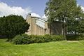
This is a category about a provincial monument in Drenthe with number PM2-0250
|
Nederlands: Klazienaveen, De Omloop 8 - Kruiskerk - anno 1963 - PKN Hervormde gemeente Klazienaveen
Media in category "Kruiskerk (Klazienaveen)"
The following 29 files are in this category, out of 29 total.
-

-
 Detail- koperen waterspuwer - Klazienaveen - 20425165 - RCE.jpg 836 × 1,200; 183 KB
-
 Exterieur overzicht - Klazienaveen - 20321537 - RCE.jpg 1,183 × 1,200; 213 KB
-
 Interieur, detail van de avondmaalstafel - Klazienaveen - 20425195 - RCE.jpg 1,200 × 798; 160 KB
-
 Interieur, detail van de kerkbank - Klazienaveen - 20425197 - RCE.jpg 798 × 1,200; 149 KB
-
 Interieur, detail van de lezenaar - Klazienaveen - 20425196 - RCE.jpg 908 × 1,200; 151 KB
-

-

-
 Interieur, overzicht - Klazienaveen - 20425177 - RCE.jpg 1,200 × 798; 140 KB
-
 Interieur, overzicht met orgel - Klazienaveen - 20425178 - RCE.jpg 1,200 × 798; 176 KB
-
 Interieur, overzicht met orgel - Klazienaveen - 20425180 - RCE.jpg 1,200 × 798; 168 KB
-
 Interieur, overzicht met orgel - Klazienaveen - 20425182 - RCE.jpg 1,200 × 798; 179 KB
-
 Interieur, overzicht van de hal - Klazienaveen - 20425185 - RCE.jpg 1,200 × 797; 180 KB
-
 Interieur, overzicht van de hal - Klazienaveen - 20425188 - RCE.jpg 1,200 × 798; 174 KB
-
 Interieur, overzicht van de hal - Klazienaveen - 20425189 - RCE.jpg 1,200 × 797; 184 KB
-
 Interieur, overzicht van de kerkeraadkamer - Klazienaveen - 20425190 - RCE.jpg 1,200 × 798; 136 KB
-

-
 Interieur, overzicht van het orgel - Klazienaveen - 20425191 - RCE.jpg 798 × 1,200; 143 KB
-

-
 Overzicht van de achtergevel - Klazienaveen - 20425161 - RCE.jpg 1,200 × 798; 224 KB
-
-
 Overzicht van de ingangspartij - Klazienaveen - 20425167 - RCE.jpg 1,200 × 798; 191 KB
-
 Overzicht van de ligging in de omgeving - Klazienaveen - 20425154 - RCE.jpg 1,200 × 804; 201 KB
-
 Overzicht van de linker zijgevel - Klazienaveen - 20425156 - RCE.jpg 1,200 × 798; 187 KB
-

-

-
 Overzicht van de voorgevel - Klazienaveen - 20425159 - RCE.jpg 1,200 × 798; 210 KB
-
 Overzicht van de voorgevel - Klazienaveen - 20425160 - RCE.jpg 1,200 × 798; 214 KB
-
 Overzicht van de zij-ingang - Klazienaveen - 20425164 - RCE.jpg 798 × 1,200; 233 KB


