Category:Kromme Nieuwegracht 37, Utrecht
Jump to navigation
Jump to search
| Object location | | View all coordinates using: OpenStreetMap |
|---|
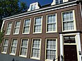
building in Utrecht, Netherlands  | |||||
| Upload media | |||||
| Instance of | |||||
|---|---|---|---|---|---|
| Location | Utrecht, Netherlands | ||||
| Street address |
| ||||
| Located on street | |||||
| Heritage designation |
| ||||
 | |||||
|
This is a category about rijksmonument number 36209
|
| Address |
|
Media in category "Kromme Nieuwegracht 37, Utrecht"
The following 5 files are in this category, out of 5 total.
-
 36209huis.JPG 4,032 × 3,024; 5.74 MB
-
 Gedeelte voorgevel, voegwerk, detail - Utrecht - 20320274 - RCE.jpg 1,200 × 783; 302 KB
-
 Kromme Nieuwegracht 37.jpg 4,000 × 3,000; 5.01 MB
-
 Overzicht voorgevel - Utrecht - 20320273 - RCE.jpg 783 × 1,200; 231 KB
-
 Voorgevel - Utrecht - 20306157 - RCE.jpg 951 × 1,200; 296 KB


