Category:Kriegsopferanlage Waldfriedhof Oberrad
Jump to navigation
Jump to search
| Object location | | View all coordinates using: OpenStreetMap |
|---|
Media in category "Kriegsopferanlage Waldfriedhof Oberrad"
The following 7 files are in this category, out of 7 total.
-
 Oberrad, Waldfriedhof, Kriegsopferanlage, Gedenkstein, Inschrift.JPG 4,928 × 3,264; 7.61 MB
-
 Oberrad, Waldfriedhof, Kriegsopferanlage, Gedenkstein.JPG 4,928 × 3,264; 7.61 MB
-
 Oberrad, Waldfriedhof, Kriegsopferanlage, Kreuz.JPG 3,264 × 4,928; 8.74 MB
-
 Waldfriedhof-Oberrad Soldatenfriedhof Denkmal Kreuz.JPG 2,448 × 3,264; 1.55 MB
-
 Waldfriedhof-Oberrad Soldatenfriedhof Denkmal.JPG 3,264 × 2,448; 1.57 MB
-
 Waldfriedhof-Oberrad Soldatenfriedhof Gräber.JPG 3,264 × 2,448; 1.57 MB
-
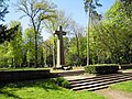
 Waldfriedhof-Oberrad Soldatenfriedhof ZentraleAchse.JPG 3,264 × 2,448; 1.58 MB


