Category:Kostyrevskaya Tower
Jump to navigation
Jump to search
| Object location | | View all coordinates using: OpenStreetMap |
|---|
This is a category about a cultural heritage object in Russia, number: 6710021012
| |
| This template and pages using it are maintained by the Russian WLM team. Please read the guidelines before making any changes that can affect the monuments database! |
 | |||||
| Upload media | |||||
| Instance of | |||||
|---|---|---|---|---|---|
| Part of | |||||
| Location | Smolensk, Smolensk Oblast, Russia | ||||
| Heritage designation |
| ||||
| Inception |
| ||||
| Dissolved, abolished or demolished date |
| ||||
 | |||||
Media in category "Kostyrevskaya Tower"
The following 16 files are in this category, out of 16 total.
-
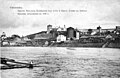
 Smolensk by Ginsburg - 00020. Kostyrevskaya tower.jpg 1,682 × 1,085; 1.08 MB
-

-
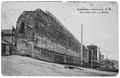
 Smolensk by Verzilov Store Publication - 029. Smolensk fortress.jpg 1,624 × 1,050; 1.12 MB
-
 Smolensk fortress wall 15.jpg 1,677 × 1,091; 1.12 MB
-
 Smolensk Kostyrevskaya Tower v1.JPG 3,648 × 2,736; 2.34 MB
-
 Smolensk Kostyrevskaya Tower v2.JPG 3,648 × 2,736; 2.5 MB
-
 Smolensk KostyrevskayaTower.jpg 2,400 × 1,748; 2.8 MB
-
 Башня Костаревская Смоленск.JPG 4,272 × 2,848; 3.78 MB
-
 Башня Костаревская.jpg 4,487 × 3,566; 9.97 MB
-
 В обломке стены - ресторан "Красная башня - panoramio.jpg 3,264 × 2,448; 2.14 MB
-
 Костыревская башня (Красная башня).JPG 2,592 × 1,944; 892 KB
-
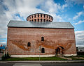
 Костыревская башня (Смоленск).jpg 3,648 × 2,736; 2.95 MB
-
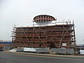 Костыревская башня на реставрации.JPG 4,000 × 3,000; 2.58 MB
-
 Костыревская башня с крепостной стены на Тимирязева.JPG 4,000 × 3,000; 5.82 MB
-
 Костыревская башня. Смоленск.jpg 3,000 × 2,250; 2.44 MB
-
 Смоленская крепость. Костыревская башня.jpg 3,998 × 2,666; 3.14 MB


.JPG)
.jpg)


