Category:Kornhaus, St. Niklaus, Koppigen
Jump to navigation
Jump to search
| Object location | | View all coordinates using: OpenStreetMap |
|---|
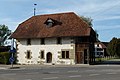
building in St. Niklaus municipality Koppigen in the canton of Bern, Switzerland  | |||||
| Upload media | |||||
| Instance of | |||||
|---|---|---|---|---|---|
| Part of | |||||
| Location | Koppigen, Emmental administrative district, Emmental-Oberaargau administrative region, Bern, Switzerland | ||||
| Street address |
| ||||
| Heritage designation | |||||
| Inception |
| ||||
| Significant event |
| ||||
 | |||||
Media in category "Kornhaus, St. Niklaus, Koppigen"
The following 2 files are in this category, out of 2 total.
-
 Koppigen St Niklaus 01.jpg 3,888 × 2,592; 4.04 MB
-
 St.Niklaus Kornspeicher.JPG 4,320 × 2,880; 4.14 MB
