Category:Koning Willem III Kazerne (Nieuwersluis)
Jump to navigation
Jump to search
| Object location | | View all coordinates using: OpenStreetMap |
|---|
 | |||||
| Upload media | |||||
| Instance of | |||||
|---|---|---|---|---|---|
| Part of | |||||
| Location | Nieuwersluis, Stichtse Vecht, Utrecht, Netherlands | ||||
| Street address |
| ||||
| Located on street |
| ||||
| Heritage designation |
| ||||
 | |||||
Nederlands: Koning Willem III Kazerne
|
This is a category about rijksmonumentcomplex number 520365
|
Kazerne (Gebouw A)
|
This is a category about rijksmonument number 520366
|
Pupillenschool (Gebouw C)
|
This is a category about rijksmonument number 520367
|
Exercitieloods / Logiesgebouw (Gebouw B)
|
This is a category about rijksmonument number 520368
|
Exercitieloods (Gebouw D)
|
This is a category about rijksmonument number 520369
|
Ziekenbarak (Gebouw I)
|
This is a category about rijksmonument number 520370
|
Onderofficierswoningen (Gebouw H)
|
This is a category about rijksmonument number 520371
|
Directeurswoning (Gebouw F)
|
This is a category about rijksmonument number 520372
|
| Address |
|
Media in category "Koning Willem III Kazerne (Nieuwersluis)"
The following 11 files are in this category, out of 11 total.
-
 Exterieur OVERZICHT VOORGEVEL - Nieuwersluis - 20340046 - RCE.jpg 1,178 × 1,200; 396 KB
-
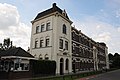 Militairy building dated 1877 at Nieuwersluis at the Vecht river - panoramio.jpg 4,288 × 2,848; 2.9 MB
-
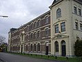
 Nieuwersluis - Pupillenschool RM520367.JPG 4,554 × 2,280; 853 KB
-
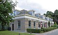
 Nieuwersluis - Willem III Kazerne Directeurswoning RM520372.JPG 3,381 × 3,000; 1.01 MB
-
 Nieuwersluis - Willem III Kazerne Onderofficierswoningen RM520371.JPG 4,506 × 2,690; 1.13 MB
-
 Nieuwersluis at the Vecht river has a lot of nice manors - panoramio.jpg 4,288 × 2,848; 3.08 MB
-
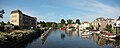 Nieuwersluis Panorama 1.JPG 5,610 × 2,258; 2.59 MB
-
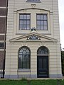
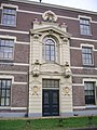 Nieuwersluis Pupillenschool voordeur.JPG 2,112 × 2,816; 1.92 MB
-
 Nieuwersluis Pupillenschool.JPG 2,816 × 2,112; 2.14 MB
-
 Nieuwersluis vrouwengevangenis.JPG 2,816 × 2,112; 1.15 MB
-
 Pupillenschool Nieuwersluis, hoekgebouw.JPG 2,112 × 2,816; 2.13 MB


