Category:Kohala (mountain)
Jump to navigation
Jump to search
mountain in Hawaii | |||||
| Upload media | |||||
| Instance of | |||||
|---|---|---|---|---|---|
| Made from material | |||||
| Location |
| ||||
| Mountain range | |||||
| Elevation above sea level |
| ||||
| Different from | |||||
 | |||||
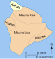
English: Kohala is the oldest of five volcanoes that make up the Big island of Hawaiʻi, located in the northwestern Kohala district. The volcano is believed to have last erupted 120,000 years ago.
Media in category "Kohala (mountain)"
The following 19 files are in this category, out of 19 total.
-
Kohala-Landsat.jpg 480 × 360; 223 KB
-
Location Kohala.svg 279 × 299; 94 KB
-
Kawaihae2.jpg 1,536 × 864; 224 KB
-
Kohala Mountains from Waimea, Hawaii at S.R. 19 (4528208379).jpg 2,816 × 2,112; 1,022 KB
-
Kohala Mountains from Waimea, Hawaii at S.R. 19.jpg 2,816 × 2,112; 1.1 MB
-
Kohala Mountains, State Route 19, near Kawaihae, Hawaii.jpg 2,816 × 2,112; 1.91 MB
-
Kohala volcano.jpeg 800 × 500; 121 KB
-
Kohala-Cros Section.jpg 474 × 51; 45 KB
-
Kohala-hawaii-2013.jpg 1,875 × 700; 1.07 MB
-
Kona coast of Island Hawaii - Kohala volcano - panoramio.jpg 3,264 × 2,448; 2.89 MB
-
Looking Toward the Kohala Mountains from S.R. 19, Kawaihae, Hawaii (4528828296).jpg 2,816 × 2,112; 1.1 MB
-
Looking Toward the Kohala Mountains from S.R. 19, Kawaihae, Hawaii.jpg 2,816 × 2,112; 2.76 MB
-
Mauna Kea - panoramio (1).jpg 3,264 × 2,448; 2.73 MB
-
Mauna Kea and Kohala Volcanic Hazard Mapping.gif 354 × 269; 25 KB
-
Niuli'i, May 2008 - panoramio.jpg 3,888 × 2,592; 3.47 MB
-
Overlooking the Kohala Coast.jpg 4,752 × 3,168; 4.76 MB
-
Pololū Valley Lookout - panoramio.jpg 3,264 × 2,448; 2.42 MB
-
Pololū Valley, United States (Unsplash).jpg 3,872 × 2,592; 1.8 MB
-
Wet forest of Kohala Mountain.jpg 700 × 525; 728 KB


