Category:Koepoortstraat 42, Doesburg
Jump to navigation
Jump to search
| Object location | | View all coordinates using: OpenStreetMap |
|---|
 | |||||
| Upload media | |||||
| Instance of |
| ||||
|---|---|---|---|---|---|
| Location | Doesburg, Gelderland, Netherlands | ||||
| Street address |
| ||||
| Located on street | |||||
| Heritage designation |
| ||||
 | |||||
|
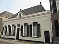
This is a category about rijksmonument number 13011
|
| Address |
|
Media in category "Koepoortstraat 42, Doesburg"
The following 11 files are in this category, out of 11 total.
-
 50, achterzijde, overzicht - Doesburg - 20057867 - RCE.jpg 1,200 × 812; 311 KB
-
 Doesburg, Netherlands - panoramio (127).jpg 2,048 × 1,155; 591 KB
-
 Doesburg, Netherlands - panoramio (132).jpg 2,048 × 1,155; 527 KB
-
 Doesburg, Netherlands - panoramio (199).jpg 4,896 × 3,264; 6.07 MB
-
 Doesburg, Netherlands - panoramio (4).jpg 2,048 × 1,375; 521 KB
-
 Doesburg, Netherlands - panoramio (7).jpg 2,048 × 1,375; 536 KB
-
 Koepoortstraat Doesburg at 13 December 2013 - panoramio.jpg 3,648 × 2,432; 2.52 MB
-
 Oost wand - Doesburg - 20058183 - RCE.jpg 1,200 × 800; 169 KB
-
 Overzicht van de voorgevel - Doesburg - 20425297 - RCE.jpg 1,200 × 894; 179 KB
-
 RM13011 Doesburg - Koepoortstraat 42.jpg 2,592 × 1,944; 1.18 MB
-
 Voorgevel - Doesburg - 20058220 - RCE.jpg 800 × 1,200; 157 KB

.jpg)
.jpg)
.jpg)
.jpg)
.jpg)


