Category:Koepoortstraat 40, Doesburg
Jump to navigation
Jump to search
| Object location | | View all coordinates using: OpenStreetMap |
|---|
 | |||||
| Upload media | |||||
| Instance of | |||||
|---|---|---|---|---|---|
| Location | Doesburg, Gelderland, Netherlands | ||||
| Street address |
| ||||
| Located on street | |||||
| Heritage designation |
| ||||
 | |||||
|
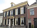
This is a category about rijksmonument number 513142
|
| Address |
|
Media in category "Koepoortstraat 40, Doesburg"
The following 14 files are in this category, out of 14 total.
-
 Doesburg with its historic center and lovely buildings - panoramio.jpg 3,648 × 2,432; 2.38 MB
-
 Doesburg, Netherlands - panoramio (127).jpg 2,048 × 1,155; 591 KB
-
 Doesburg, Netherlands - panoramio (130).jpg 2,048 × 1,155; 567 KB
-
 Doesburg, Netherlands - panoramio (199).jpg 4,896 × 3,264; 6.07 MB
-
 Doesburg, Netherlands - panoramio (4).jpg 2,048 × 1,375; 521 KB
-
 Doesburg, Netherlands - panoramio (47).jpg 2,048 × 1,148; 489 KB
-
 Koepoortstraat Doesburg at 13 December 2013 - panoramio.jpg 3,648 × 2,432; 2.52 MB
-
 Oost wand - Doesburg - 20058183 - RCE.jpg 1,200 × 800; 169 KB
-
 Overzicht van de voorgevel - Doesburg - 20425281 - RCE.jpg 1,200 × 1,176; 230 KB
-
 Overzicht van de voorgevel - Doesburg - 20425282 - RCE.jpg 1,073 × 1,200; 225 KB
-
 Overzicht van de voorgevel - Doesburg - 20425283 - RCE.jpg 1,086 × 1,200; 215 KB
-
 RM513142 Doesburg - Koepoortstraat 40.jpg 2,592 × 1,944; 1.27 MB
-
 Voorgevel - Doesburg - 20058218 - RCE.jpg 809 × 1,200; 161 KB
-
 Voorgevel - Doesburg - 20058219 - RCE.jpg 816 × 1,200; 223 KB

.jpg)
.jpg)
.jpg)
.jpg)
.jpg)


