Category:Koepoortstraat 23, Doesburg
Jump to navigation
Jump to search
| Object location | | View all coordinates using: OpenStreetMap |
|---|
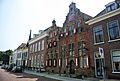
building in Doesburg, Netherlands  | |||||
| Upload media | |||||
| Instance of | |||||
|---|---|---|---|---|---|
| Location | Doesburg, Gelderland, Netherlands | ||||
| Street address |
| ||||
| Located on street | |||||
| Heritage designation |
| ||||
 | |||||
|
This is a category about rijksmonument number 12990
|
| Address |
|
Media in category "Koepoortstraat 23, Doesburg"
The following 5 files are in this category, out of 5 total.
-
 Doesburg, Netherlands - panoramio (5).jpg 2,048 × 1,375; 412 KB
-
 Noord gedeelte west wand - Doesburg - 20058186 - RCE.jpg 1,200 × 800; 170 KB
-
 RM12990 Doesburg - Koepoortstraat 23.jpg 1,944 × 2,592; 1.16 MB
-

-
 Voor- en zijgevel - Doesburg - 20058202 - RCE.jpg 1,200 × 804; 139 KB
.jpg)


