Category:Knowsley Road bridge, Bootle
Jump to navigation
Jump to search
| Object location | | View all coordinates using: OpenStreetMap |
|---|
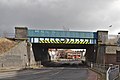
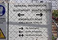
This bridge is one structure but has two identities as it carries lines on two sections of the network:
- HXS3/19 carries the up and down Southport lines of the Northern Line of Merseyrail and is the eastern side of the bridge. It is 3.67 miles from its datum at Liverpool Exchange station.
- NMM/19 on the western side carries the North Mersey Branch to Marsh Lane Junction Curve, now largely disused except for engineering access. It is 34.54 miles from its datum at Manchester Victoria.
Media in category "Knowsley Road bridge, Bootle"
The following 5 files are in this category, out of 5 total.
-
 Knowsley Road bridge, Bootle 1.jpg 4,673 × 3,431; 14.57 MB
-
 Knowsley Road bridge, Bootle 2.jpg 5,002 × 3,333; 18.72 MB
-
 Knowsley Road bridge, Bootle info board.jpg 4,729 × 3,214; 16.27 MB
-
 Knowsley Road bridgeplate1.jpg 3,734 × 2,976; 13.71 MB
-
 Knowsley Road bridgeplate2.jpg 3,727 × 2,408; 9.84 MB


