Category:Kneuterdijk 2, The Hague
Jump to navigation
Jump to search
| Object location | | View all coordinates using: OpenStreetMap |
|---|
 | |||||
| Upload media | |||||
| Instance of | |||||
|---|---|---|---|---|---|
| Location | The Hague, South Holland, Netherlands | ||||
| Located on street |
| ||||
| Architect |
| ||||
| Commissioned by |
| ||||
| Occupant |
| ||||
| Heritage designation |
| ||||
 | |||||
|
This is a category about rijksmonument number 459723
|
| Address |
|
Media in category "Kneuterdijk 2, The Hague"
The following 29 files are in this category, out of 29 total.
-
 Hoek Plaats exterieur - 's-Gravenhage - 20088860 - RCE.jpg 1,200 × 957; 206 KB
-
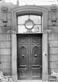 Ingang - 's-Gravenhage - 20088835 - RCE.jpg 856 × 1,200; 180 KB
-
 Ingangspartij - 's-Gravenhage - 20088836 - RCE.jpg 876 × 1,200; 197 KB
-
 Interieur, schoorsteen - 's-Gravenhage - 20411124 - RCE.jpg 1,200 × 948; 222 KB
-

-
 Plafond - 's-Gravenhage - 20088837 - RCE.jpg 1,200 × 899; 212 KB
-
 Plafonds - 's-Gravenhage - 20088839 - RCE.jpg 1,200 × 852; 155 KB
-
 Plafonds - 's-Gravenhage - 20088840 - RCE.jpg 1,200 × 868; 143 KB
-
 Plafonds - 's-Gravenhage - 20088841 - RCE.jpg 1,200 × 863; 156 KB
-
 Plafonds - 's-Gravenhage - 20088842 - RCE.jpg 1,200 × 863; 134 KB
-
 Plafonds - 's-Gravenhage - 20088843 - RCE.jpg 1,200 × 892; 176 KB
-
 Plafonds - 's-Gravenhage - 20088844 - RCE.jpg 1,200 × 936; 205 KB
-
 Plafonds - 's-Gravenhage - 20088845 - RCE.jpg 1,200 × 898; 225 KB
-
 Plafonds - 's-Gravenhage - 20088846 - RCE.jpg 1,200 × 898; 280 KB
-
 Plafonds - 's-Gravenhage - 20088847 - RCE.jpg 1,200 × 903; 222 KB
-
 Plafonds - 's-Gravenhage - 20088848 - RCE.jpg 1,200 × 906; 273 KB
-
 Rm459723.JPG 3,648 × 2,736; 2.16 MB
-
 Schoorstenen - 's-Gravenhage - 20088856 - RCE.jpg 868 × 1,200; 135 KB
-
 Schoorstenen - 's-Gravenhage - 20088857 - RCE.jpg 855 × 1,200; 105 KB
-
 Schoorstenen - 's-Gravenhage - 20088858 - RCE.jpg 863 × 1,200; 183 KB
-
 Schoorstenen - 's-Gravenhage - 20088859 - RCE.jpg 856 × 1,200; 174 KB
-
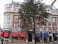
 The Hague - Den Haag - La Haye (31021100718).jpg 3,746 × 2,615; 1.53 MB
-
 Wand - 's-Gravenhage - 20088849 - RCE.jpg 854 × 1,200; 115 KB
-
 Wand - 's-Gravenhage - 20088850 - RCE.jpg 868 × 1,200; 126 KB
-
 Wand - 's-Gravenhage - 20088851 - RCE.jpg 861 × 1,200; 98 KB
-
 Wand - 's-Gravenhage - 20088852 - RCE.jpg 863 × 1,200; 129 KB
-
 Wand - 's-Gravenhage - 20088853 - RCE.jpg 1,200 × 866; 130 KB
-
 Wand - 's-Gravenhage - 20088854 - RCE.jpg 920 × 1,200; 114 KB
-
 Wand - 's-Gravenhage - 20088855 - RCE.jpg 912 × 1,200; 156 KB


.jpg)


